


Vilna Governorate
Vilna Governorate
| |
|---|---|
 Coat of arms | |
.svg) Location in the Russian Empire | |
| Country | Russian Empire |
| Krai | Northwestern |
| Established | 1795 |
| Abolished | 1918 |
| Capital | Vilnius |
| Area | |
• Total | 41,907.9 km2 (16,180.7 sq mi) |
| Highest elevation | 293.84 m (964.0 ft) |
| Population (1897) | |
• Total | 1,591,207 |
| • Density | 37.9691/km2 (98.3396/sq mi) |
| • Urban | 12.44% |
| • Rural | 87.56% |
| History of Lithuania |
|---|
 |
| Chronology |
|
|
_(1845).png)
The Vilna Governorate[a] was a province (guberniya) of the Northwestern Krai of the Russian Empire that existed from 1795 to 1918. Established after the Third Partition of the Polish–Lithuanian Commonwealth, it encompassed territories of the former Grand Duchy of Lithuania and was one of the administrative divisions created by the Russian Empire to replace the institutions of the dissolved Polish–Lithuanian Commonwealth.
In 1897, the governorate covered an area of 41,907.9 square kilometres (16,180.7 mi2) and had a population of 1,591,207 inhabitants. It bordered the following governorates: Minsk to the south, Grodno to the southwest, Suwałki to the west, Kovno and Courland to the north, and Vitebsk to the east. Its capital, Vilnius, also served as the seat of the Vilna Governorate-General, which existed until 1912.
History
Following the Third Partition of the Polish–Lithuanian Commonwealth in 1795, the former lands of the Grand Duchy of Lithuania (themselves part of the Polish–Lithuanian Commonwealth) were annexed by the Russian Empire. The Russians established two administrative units: the Vilnius Governorate and the Slonim Governorate. On 12 December 1796, by order of Tsar Paul I, these were merged into a single administrative unit called the Lithuania Governorate, with its capital in Vilnius.[1]
On 9 September 1801, Tsar Alexander I divided the Lithuanian Governorate into two: the Lithuania Vilnius Governorate and the Lithuania Grodno Governorate. Around 1840–1843, during the administrative reforms of Tsar Nicholas I, the word "Lithuania" was officially erased from both names and the Vilna Governorate and Grodno Governorate were established.[2]
In 1843, another reform created the new Kovno Governorate out of seven western districts of the Vilna Governorate, including most of Samogitia. In exchange, the Vilna Governorate received the districts of Vileyka and Dzisna from the Minsk Governorate and Lida from the Grodno Governorate.[3] Thereafter, the Vilna Governorate consisted of the districts of Vilnius, Trakai, Dzisna, Ashmyany, Lida, Vileyka and Švenčionys. This administrative structure remained in place until the outbreak of World War I, when the region came under German occupation as part of the Ober Ost military administration.
- Maps of the Vilna Governorate
-
 Vilna Governorate (light green), 1795–97, with modern Lithuania outlined
 -
 Vilna Governorate (light green), 1843–1915, with modern Lithuania outlined
 -
 Vilna Governorate in 1897


Demographics
Plater's statistics of 1825
Count Stanisław Plater was the first one in 1825 to publish approximate statistics on the ethnic makeup of the Vilnius Governorate, which then included most, but not all, of Lithuania.[4] His work's purpose was to show the area's indicative ethnic composition.[4] In the case of the Vilnius Governorate, before a major redrawing of the governorate's borders in 1843, he concluded that it was majority Lithuanian.[4][5]
| Language | People | Percentage
of total |
|---|---|---|
| Lithuanian | 780,000 | 65% |
| Yiddish | 180,000 | 15% |
| Polish | 100,000 | 8,3% |
| Russians | 80,000 | 6,7% |
| Ruthenians | 50,000 | 4,2% |
| Tatars | 10,000 | 0,8% |
| Total | 1,200,000 | 100% |
Due to the lack of systematic primary data on nationalities, Plater resorted to comparing the revision censuses and religious distribution statistics to provide the general statistics on the population's ethnic distribution.[4] He referred to nobles and townspeople, with the exception of soldiers and Jews, as Poles, whereas he separated the peasants into Lithuanians, Ruthenians, or Russians (which refers to the Old Believers).[4] Overall, the total number of Catholics in the Vilnius Governorate was 930,000, i.e. ¾ of the population.[4][8]
Plater's ethnic and social classification of the population also reflected the contemporary thought among the elite classes, where in addition to a class difference, an ethnic dividing line was also drawn compared to the lower classes.[7] Thus, Plater categorically renamed the Lithuanians of the traditional political Lithuanian nation as Poles, whereas the lower classes in his view were termed as Lithuanians.[7][9] A similar attitude could be found elsewhere in Europe, for example, the Hungarian nobility called itself as Natio Hungarica, in contrast to the commoners they called Magyars.[7]
In 1856, a clear example of the ethno-social alienation between a Polish-speaking Lithuanian noble and a Lithuanian-speaking peasant was documented when the poet and writer Władysław Syrokomla, who traditionally considered himself a Lithuanian, traveled through the Dūkštos parish.[7] Somewhere between the Geišiškės and Europa estates, Syrokomla spoke to a villager in Polish, but the latter replied in Lithuanian that he did not understand him, upon which Syrokomla disappointedly exclaimed that: "A Lithuanian in a Lithuanian land could not speak to a Lithuanian".[7]
Russian Empire Census
According to the Russian Empire census on 28 January [O.S. 15 January] 1897, The Vilna Governorate had a population of 1,591,207, including 790,880 men and 800,327 women. According to the census, the majority of the population indicated Belarusian to be their mother tongue, which followed by a significant Lithuanian and Jewish speakers.[10]
| Language | Native speakers | Percentage |
|---|---|---|
| White Russian[b] | 891,903 | 56.05 |
| Lithuanian | 279,720 | 17.58 |
| Jewish | 202,374 | 12.72 |
| Polish | 130,054 | 8.17 |
| Great Russian[b] | 78,623 | 4.94 |
| German | 3,873 | 0.24 |
| Tatar | 1,969 | 0.12 |
| Little Russian[b] | 919 | 0.06 |
| Latvian | 471 | 0.03 |
| Gypsi | 182 | 0.01 |
| Others | 1,119 | 0.07 |
| Total | 1,591,207 | 100.00 |
| Faith | Male | Female | Both | |
|---|---|---|---|---|
| Number | Percentage | |||
| Roman Catholic | 460,627 | 475,222 | 935,849 | 58.81 |
| Eastern Orthodox | 214,225 | 201,070 | 415,295 | 26.10 |
| Judaism | 98,193 | 106,493 | 204,686 | 12.86 |
| Old Believer | 12,686 | 12,987 | 25,673 | 1.61 |
| Lutheranism | 2,172 | 2,291 | 4,463 | 0.28 |
| Islam | 2,572 | 1,803 | 4,375 | 0.27 |
| Karaite | 251 | 325 | 576 | 0.04 |
| Reformed | 92 | 85 | 177 | 0.01 |
| Armenian Catholic | 22 | 25 | 47 | 0.00 |
| Armenian Apostolic | 9 | 3 | 12 | 0.00 |
| Mennonite | 2 | 0 | 2 | 0.00 |
| Anglican | 0 | 2 | 2 | 0.00 |
| Other Christian denomination | 19 | 16 | 35 | 0.00 |
| Other non-Christian denomination | 10 | 4 | 14 | 0.00 |
| Total | 790,880 | 800,327 | 1,591,207 | 100.00 |
Subdivisions
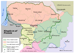
The counties (uezd) of the Vilna Governorate in 1897 was composed of seven uezds as follows:[10]
| County | Capital and
the largest city |
Arms of capital | Area | Population (1897 census) | ||
|---|---|---|---|---|---|---|
| Transliteration | Russian Cyrillic | 1897[14] | ||||
| Vileyskiy | Вилейскій | Vileyka | 3.560 | _(1845).png) |
6,363.13 km2 (2,456.82 mi2) |
208,013 |
| Vilenskiy | Виленскій | Vilna | 154.132 | |
6,185.14 km2 (2,388.10 mi2) |
363,313 |
| Disnenskiy | Дисненскій | Disna | 6.756 | _(1845).gif) |
5,779.30 km2 (2,231.40 mi2) |
204,923 |
| Lidskiy | Лидскій | Lida | 9.323 | _(1845).png) |
5,606.20 km2 (2,164.57 mi2) |
205,767 |
| Oshmyanskiy | Ошмянскій | Oshmyany | 7.214 | _(1845).png) |
6,885.39 km2 (2,658.46 mi2) |
233,559 |
| Smorgonskiy | Сморгонскій | Smorgon | --- |  |
5,979.20 km2 (2,308.58 mi2) |
241,565 |
| Sventsyanskiy | Свѣнцянскій | Sventsyany | 6.025 | _(1845).gif) |
5,228.03 km2 (2,018.55 mi2) |
172,231 |
| Trokskiy | Трокскій | Troki | 3.240 | _(1845).gif) |
5,862.27 km2 (2,263.44 mi2) |
203,401 |
Ethnic composition
Russian authorities periodically performed censuses. However, they reported strikingly different numbers:[15]
| Year | Total | Lithuanians | Poles | Belarusians | Russians | Jews | Other | ||||||
|---|---|---|---|---|---|---|---|---|---|---|---|---|---|
| 1862 | 838,464 | 418,880 | 50% | 154,386 | 18% | 146,431 | 17% | 14,950 | 2% | 76,802 | 9% | 27,035 | 3% |
| 1865 | 891,715 | 210,273 | 24% | 154,386 | 17% | 418,289 | 47% | 27,845 | 3% | 76,802 | 9% | 4,120 | 0% |
| 1883 | 1,192,000 | 417,200 | 35% | 281,312 | 24% | 239,592 | 20% | N/a | 176,416 | 15% | 77,480 | 7% | |
| 1897 | 1,561,713 | 274,414 | 18% | 126,770 | 8% | 880,940 | 56% | 75,803 | 5% | 197,929 | 13% | 5,857 | 0% |
| 1909 | 1,550,057 | 231,848 | 15% | 188,931 | 12% | 570,351 | 37% | 408,817 | 26% | 146,066 | 9% | 4,094 | 0% |
Governors
| Name | In office |
|---|---|
| Yakov Bulgarov | 1797–1799 |
| Ivan Friesell | 1799–1801 |
| Dmitry Lanskoy | 1802–1804 |
| Ivan Rickman | 1804–1806 |
| Prokopy Bogmevsky | 1806–1808 |
| Nikolay Brusilov | 1808–1810 |
| Aleksandr Lavinsky | 1811–1816 |
| Friedrich Drutsky-Lyubetsky | 1816–1823 |
| Pyotr Gorn | 1823–1830 |
| Dmitry Obreskov | 1830–1832 |
| Grigory Doppelmayr | 1832–1836 |
| Dmitry Bantysh-Kamensky | 1836–1838 |
| Yuri Dolgorukov | 1838–1840 |
| Aleksey Semyonov | 1840–1844 |
| Nikolay Zherebtsov | 1844–1846 |
| Mikhail Begichev | 1846–1851 |
| Arkady Rosset | 1851–1857 |
| Mikhail Pokhvisnev | 1857–1863 |
| Ivan Galler | 1863–1863 |
| Stepan Panyutin | 1863–1868 |
| Ivan Shestakov | 1868–1869 |
| Yegor Steblin-Kamensky | 1869–1882 |
| Aleksandr Zhemchuzhnikov | 1882–1885 |
| Nikolay Grevenits | 1885–1895 |
| Aleksandr Frese | 1895–1896 |
| Ivan Cheplevsky | 1896–1899 |
| Nikolai Gruzinsky | 1899–1901 |
| Viktor Wahl | 1901–1902 |
| Konstantin Palen | 1902–1905 |
| Sergey Tatishchev | 1905–1906 |
| Dmitry Lyubimov | 1906–1912 |
| Pyotr Veryovkin | 1912–1916 |
| Aleksandr Tolstoy | 1916–1917 |
See also
- Demographic history of the Vilnius region
- History of Vilnius
- Wilno Voivodeship (1926–1939)
- Vileyka Region
Notes
- ^
- Russian: Ви́ленская губе́рния, pre-reform orthography: Ви́ленская губе́рнія, romanized: Vílenskaya gubérniya
- Belarusian: Ві́ленская губе́рня, romanized: Vílenskaya hubérnya
- Lithuanian: Vilniaus gubernija
- Polish: Gubernia wileńska
- ^ a b c Prior to 1918, the Imperial Russian Government classified Russians as the Great Russians, Ukrainians as the Little Russians, and Belarusians as the White Russians. After the creation of the Ukrainian People's Republic in 1918, the Little Russians identified themselves as "Ukrainian".[11] Also, the Belarusian Democratic Republic which the White Russians identified themselves as "Belarusian".[12]
References
- ^ Kulakauskas, Antanas (2002). "Administracinės reformos". Gimtoji istorija. Nuo 7 iki 12 klasės (in Lithuanian). Vilnius: Elektroninės leidybos namai.
- ^ "Литовская губерния". Брокгауз и Ефрон (in Russian). 1890–1906.
- ^ Simas Sužiedėlis, ed. (1970–1978). "Administration". Encyclopedia Lituanica. Vol. I. Boston, Massachusetts: Juozas Kapočius. pp. 17–21. LCCN 74-114275.
- ^ a b c d e f Merkys 2004, p. 24.
- ^ a b Merkys 2006, p. 41.
- ^ Plater 1825, p. 206.
- ^ a b c d e f Merkys 2004, p. 25.
- ^ Merkys 2006, p. 28.
- ^ Merkys 2006, p. 42.
- ^ a b c Первая всеобщая перепись населения Российской Империи 1897 г. Распределение населения по родному языку и уездам 50 губерний Европейской России [The First General Census of the Russian Empire of 1897. Breakdown of population by mother tongue and districts in 50 Governorates of the European Russia]. www.demoscope.ru (in Russian). Retrieved 2023-04-27.
- ^ Hamm, Michael F. (2014). Kiev: A Portrait, 1800–1917. Princeton University Press. p. 83. ISBN 978-1-4008-5151-5.
- ^ Fortson IV, Benjamin W. (2011). Indo-European Language and Culture: An Introduction. John Wiley & Sons. p. 429. ISBN 978-1-4443-5968-8.
- ^ Первая всеобщая перепись населения Российской Империи 1897 г. Распределение населения по вероисповеданиям и регионам [The first general census of the population of the Russian Empire in 1897. Breakdown of population by religions and regions]. www.demoscope.ru (in Russian). Retrieved 2023-04-28.
- ^ "Демоскоп Weekly - Приложение. Справочник статистических показателей". www.demoscope.ru. Retrieved 2024-10-10.
- ^ Nikolajew, Christina Juditha (2005). Zum Zusammenhang zwischen nationaler Identitätsbildung und Katholischer Kirche in Litauen (PDF) (in German). Eberhard Karls University of Tübingen. p. 16.[permanent dead link]
Sources
- Merkys, Vytautas (2004). "Vilniaus Vyskupija 1795–1864 m.: Nuo politinės link kultūrinės tautos" [Vilnius Diocese 1795–1864: From a political to a cultural nation] (PDF). Lietuvių Katalikų Mokslo Akademijos Metraštis (in Lithuanian). 24. Vilnius.
- Merkys, Vytautas (2006). Tautiniai santykiai Vilniaus vyskupijoje 1798–1918 m. [National relations in the Vilnius Diocese in 1798-1918] (in Lithuanian). Vilnius: Versus aureus. ISBN 9955-699-42-6.
- Plater, Stanisław (1825). Jeografia wschodniéy części Europy czyli Opis krajów przez wielorakie narody słowiańskie zamieszkanych : obejmujący Prussy, Xsięztwo Poznańskie, Szląsk Pruski, Gallicyą, Rzeczpospolitę Krakowską, Krolestwo Polskie i Litwę [Geography of the Eastern Part of Europe, or Description of the Countries inhabited by Various Slavic Nations: Including Prussia, the Duchy of Posen, Prussian Silesia, Galicia, the Republic of Cracow, the Kingdom of Poland, and Lithuania] (in Polish). Wrocław: Wilhelm Bogumił Korn.
| Northwestern Krai | |
|---|---|
| Southwestern Krai | |