


St. Charles, South Carolina
St. Charles, South Carolina | |
|---|---|
 Buildings in St. Charles | |
 St. Charles  St. Charles | |
| Coordinates: 34°05′06″N 80°14′15″W / 34.08500°N 80.23750°W[1] | |
| Country | United States |
| State | South Carolina |
| County | Lee |
| Area | |
• Total | 4.24 sq mi (10.97 km2) |
| • Land | 4.24 sq mi (10.97 km2) |
| • Water | 0 sq mi (0.00 km2) |
| Elevation | 174 ft (53 m) |
| Population | |
• Total | 114 |
| • Density | 26.9/sq mi (10.39/km2) |
| Time zone | UTC-5 (Eastern (EST)) |
| • Summer (DST) | UTC-4 (EDT) |
| ZIP Codes | |
| Area codes | 803/839 |
| FIPS code | 45-62485 |
| GNIS feature ID | 2807067[1] |
St. Charles or Saint Charles[1] is an unincorporated community and census-designated place (CDP) in Lee County, South Carolina, United States. It was first listed as a CDP prior to the 2020 census[1] with a population of 114.[4]
The CDP is in southern Lee County, at the junction of U.S. Route 401 and South Carolina Highway 154. Highway 401 leads northeast 25 miles (40 km) to Darlington and southwest 13 miles (21 km) to Sumter, while Highway 154 leads north 11 miles (18 km) to Bishopville and south 6 miles (10 km) to Mayesville.
Demographics
| Census | Pop. | Note | %± |
|---|---|---|---|
| 2020 | 114 | — | |
| U.S. Decennial Census[5] 2020[6][3] | |||
2020 census
| Race / Ethnicity | Pop 2020[6] | % 2020 |
|---|---|---|
| White alone (NH) | 49 | 42.98% |
| Black or African American alone (NH) | 59 | 51.75% |
| Native American or Alaska Native alone (NH) | 0 | 0.00% |
| Asian alone (NH) | 0 | 0.00% |
| Pacific Islander alone (NH) | 0 | 0.00% |
| Some Other Race alone (NH) | 0 | 0.00% |
| Mixed Race/Multi-Racial (NH) | 3 | 2.63% |
| Hispanic or Latino (any race) | 3 | 2.63% |
| Total | 114 | 100.00% |
Note: the US Census treats Hispanic/Latino as an ethnic category. This table excludes Latinos from the racial categories and assigns them to a separate category. Hispanics/Latinos can be of any race.
References
- ^ a b c d e U.S. Geological Survey Geographic Names Information System: St. Charles, South Carolina
- ^ "ArcGIS REST Services Directory". United States Census Bureau. Retrieved October 15, 2022.
- ^ a b "Census Population API". United States Census Bureau. Retrieved October 15, 2022.
- ^ "St. Charles CDP, South Carolina". United States Census Bureau. Retrieved April 7, 2022.
- ^ "Decennial Census of Population and Housing by Decades". US Census Bureau.
- ^ a b "P2 HISPANIC OR LATINO, AND NOT HISPANIC OR LATINO BY RACE – 2020: DEC Redistricting Data (PL 94-171) – St. Charles CDP, South Carolina". United States Census Bureau.
Municipalities and communities of Lee County, South Carolina, United States | ||
|---|---|---|
| City | 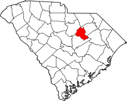 | |
| Town | ||
| CDPs | ||
| Other communities | ||
| Footnotes | ‡This populated place also has portions in an adjacent county or counties | |