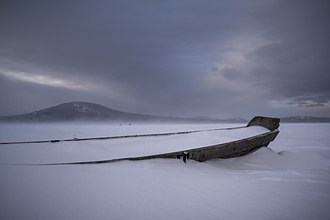
Zyuratkul (Russian: Зюраткуль; Bashkir: Йөрәккүл) is a freshwater lake in Satkinsky District, Chelyabinsk Oblast, Russia.[2]
The name "Zyuratkul" comes from the Bashkir "yöräk/kul" (йөрәк/күл), meaning "heart/lake".[3]
In 1993 the Zyuratkul National Park, a protected area, was established in the lake and its surroundings.[4]
Geography
The lake lies at 724 m (2,375 ft) above mean sea level, being one of the highest lakes of the Southern Urals. It is located about 5 km (3.1 mi) to the south of the small mountain range named after it. Its southern shore stretches at the feet of the northern slopes of the larger Nurgush range.[5] Previously, in its natural state, the lake was smaller and surrounded by swamps. After WWII a dam was built and the new reservoir doubled the surface area of the ancient lake.[6]
The water of Zyuratkul is not as clear as is normal in high-altitude lakes. The reason is that the inflowing watercourses originate in swamps. The Bolshaya Satka, a left hand tributary of the Ay, is the outflow of the lake.[2]
 |
 |
See also
References
- ^ Google Earth
- ^ a b State Water Register - Озеро Зюрат-Куль
- ^ Энциклопедия «От Парижа до Берлина по карте Челябинской области» (топонимика Челябинской области) Зюрат-Куль.
- ^ Zyuratkul National Park official site
- ^ Челябинская область: Энциклопедия / гл.ред. К. Н. Бочкарёв. Ч.: Каменный пояс, 2008
- ^ Nash-Ural - Озеро Зюраткуль
External links
 Media related to Zyuratkul Lake at Wikimedia Commons
- Lake Zyuratkul pictures (in Russian)
- Путешествия по России 35 самых красивых мест, которые должен увидеть каждый (35 most beautiful spots in Russia)


