


Size of this JPG preview of this TIF file: 800 × 505 pixels. Other resolutions: 320 × 202 pixels | 640 × 404 pixels | 1,024 × 646 pixels | 1,280 × 807 pixels | 2,560 × 1,614 pixels | 9,768 × 6,160 pixels.
Original file (9,768 × 6,160 pixels, file size: 172.15 MB, MIME type: image/tiff)
Summary
| Description |
English: Bird's-eye view. "Copyright secured. 1890." Relief shown pictorially. Available also through the Library of Congress Web site as a raster image. Includes index to points of interest. Copy imperfect: Brittle, torn, backed by rice paper. PM3 Acquisitions control no.: 2007-211 |
||
| Title | Brandon, Vt. | ||
| Shelf ID | G3754.B68A3 1890 .B8 G3754.B68A3 1890 .B8 Copy 2 | ||
| Date | |||
| Source | https://www.loc.gov/item/2008624004/ | ||
| Author | Burleigh, L. R. (Lucien R.); Burleigh, L. R. | ||
| Permission (Reusing this file) |
|
||
| Other versions |
|
||
| Location | United States · Vermont · Brandon | ||
| Part of | American Memory · Cities And Towns · Catalog · Panoramic Maps · Geography And Map Division | ||
| Subject | Brandon (Vt.) · United States · Vermont · Aerial Views · Brandon |


Licensing
|
This is a faithful photographic reproduction of a two-dimensional, public domain work of art. The work of art itself is in the public domain for the following reason:
The official position taken by the Wikimedia Foundation is that "faithful reproductions of two-dimensional public domain works of art are public domain".
This photographic reproduction is therefore also considered to be in the public domain in the United States. In other jurisdictions, re-use of this content may be restricted; see Reuse of PD-Art photographs for details. | ||||
File history
Click on a date/time to view the file as it appeared at that time.
| Date/Time | Thumbnail | Dimensions | User | Comment | |
|---|---|---|---|---|---|
| current | 13:08, 1 June 2018 | 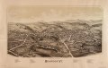 | 9,768 × 6,160 (172.15 MB) | Fæ | LOC Maps https://www.loc.gov/item/2008624004/ #1572 |
File usage
The following page uses this file:


