


File:PM6w T08 R11 S27 p099 copy.jpg

Size of this preview: 800 × 459 pixels. Other resolutions: 320 × 184 pixels | 640 × 367 pixels | 1,024 × 588 pixels | 1,280 × 735 pixels | 2,560 × 1,469 pixels | 7,710 × 4,425 pixels.
Original file (7,710 × 4,425 pixels, file size: 997 KB, MIME type: image/jpeg)
Summary
| Description |
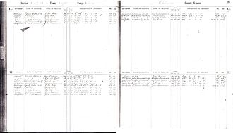
English: Example of a section index page, which lists property transactions 1890-1903 in Kansas, Osborne county, in the square mile identified as Township 8, Range 11, Section 27. |
| Date | |
| Source | Own work |
| Author | Tgkohn |
Licensing
I, the copyright holder of this work, hereby publish it under the following license:
This file is licensed under the Creative Commons Attribution-Share Alike 3.0 Unported license.
- You are free:
- to share – to copy, distribute and transmit the work
- to remix – to adapt the work
- Under the following conditions:
- attribution – You must give appropriate credit, provide a link to the license, and indicate if changes were made. You may do so in any reasonable manner, but not in any way that suggests the licensor endorses you or your use.
- share alike – If you remix, transform, or build upon the material, you must distribute your contributions under the same or compatible license as the original.
File history
Click on a date/time to view the file as it appeared at that time.
| Date/Time | Thumbnail | Dimensions | User | Comment | |
|---|---|---|---|---|---|
| current | 20:02, 9 October 2013 | | 7,710 × 4,425 (997 KB) | Tgkohn | User created page with UploadWizard |
File usage
The following page uses this file: