


File:PIA17934-MartianSlope-SeasonalDarkFlows-20140210.jpg

Summary
| Description |
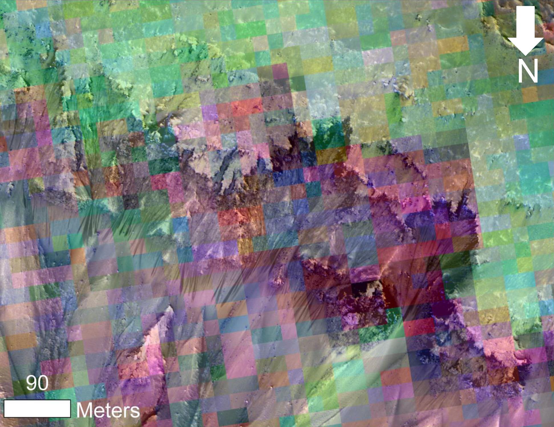
English: Color-Coded Clues to Composition Superimposed on Martian Seasonal-Flow Image
http://www.jpl.nasa.gov/spaceimages/details.php?id=PIA17934 Date added: 2014-02-10 Spacecraft: Mars Reconnaissance Orbiter (MRO) Instruments: High Resolution Imaging Science Experiment (HiRISE) This image combines a photograph of seasonal dark flows on a Martian slope with a grid of colors based on data collected by a mineral-mapping spectrometer observing the same area. The area is at Palikir Crater in the southern hemisphere of Mars. The photograph is from the High Resolution Imaging Science Experiment (HiRISE) camera. The composition information, as an image with pixels appearing as a grid of squares, is from the Compact Reconnaissance Imaging Spectrometer for Mars (CRISM). Both of these instruments are on NASA's Mar Reconnaissance Orbiter. The view is oriented with north toward the bottom. The scale bar at lower left indicates 90 meters (295 feet). These dark, warm-season flows are called "recurring slope lineae" or RSL. Researchers are using observations from Mars orbiters to study the possibility that RSL result from action of salty liquid water. This image was included in a paper by Lujendra Ojha of Georgia Institute of Technology, Atlanta, and co-authors in Geophysical Research Letters. The purple and pink colors of the CRISM image represent spectra with absorption of light at wavelengths of 920 nanometers and 530 nanometers. The strength of these absorption bands at this site varies seasonally -- weaker when the RSL are inactive and stronger when the RSL are active. Absorption at 530 nanometers can indicate a concentration of ferric iron, so this could be a clue that the fluctuations observed in the absorption bands of iron minerals may be related to the RSL activity. Other image products from the same Nov. 2, 2007, HiRISE observation are available at http://www.uahirise.org/PSP_005943_1380. The Johns Hopkins University Applied Physics Laboratory, Laurel, Md., operates CRISM in coordination with an international team of researchers from universities, government and the private sector. The University of Arizona Lunar and Planetary Laboratory, Tucson, operates HiRISE, which was built by Ball Aerospace & Technologies Corp., Boulder, Colo. NASA's Jet Propulsion Laboratory, a division of the California Institute of Technology in Pasadena, manages the Mars Reconnaissance Orbiter for NASA's Science Mission Directorate, Washington. For more about NASA's Mars exploration missions, see http://www.nasa.gov/mars and http://mars.jpl.nasa.gov. |
| Date | |
| Source | http://photojournal.jpl.nasa.gov/jpeg/PIA17934.jpg |
| Author | NASA/JPL-Caltech/UA/JHU-APL |
Licensing

|
The copyright holder of this file, NASA/JPL-Caltech, allows anyone to use it for any purpose, provided that the copyright holder is properly attributed. Redistribution, derivative work, commercial use, and all other use is permitted. |
|
|
| According to JPL's image use policy additional restriction is that no endorsement of any product or service by Caltech, JPL or NASA is claimed or implied.
Caltech's disclaimer: Caltech makes no representations or warranties with respect to ownership of copyrights in the images, and does not represent others who may claim to be authors or owners of copyright of any of the images, and makes no warranties as to the quality of the images. Caltech shall not be responsible for any loss or expenses resulting from the use of the images, and you release and hold Caltech harmless from all liability arising from such use. Usage on the English Wikipedia: On the English Wikipedia you can use the {{JPL Image}} template to display the copyright notice. (See w:Wikipedia:Using JPL images for details) |
File history
Click on a date/time to view the file as it appeared at that time.
| Date/Time | Thumbnail | Dimensions | User | Comment | |
|---|---|---|---|---|---|
| current | 19:30, 18 February 2014 | | 1,942 × 1,495 (338 KB) | Drbogdan | User created page with UploadWizard |
File usage
The following 2 pages use this file:
Global file usage
The following other wikis use this file:
- Usage on ar.wikipedia.org
- Usage on es.wikipedia.org
- Usage on it.wikipedia.org
- Usage on pnb.wikipedia.org
- Usage on th.wikipedia.org
- Usage on tr.wikipedia.org
- Usage on ur.wikipedia.org
- Usage on zh.wikipedia.org