


Roseville, Barren County, Kentucky
Roseville, Kentucky | |
|---|---|
 Roseville, Kentucky | |
| Coordinates: 36°53′14″N 85°55′32″W / 36.88722°N 85.92556°W | |
| Country | United States |
| State | Kentucky |
| County | Barren |
| Elevation | 741 ft (226 m) |
| Time zone | UTC-6 (Central (CST)) |
| • Summer (DST) | UTC-5 (CDT) |
| Area code | 270 |
| GNIS feature ID | 502353[1] |
Roseville is an unincorporated community in Barren County, Kentucky, United States. Roseville is located at the junction of Kentucky Route 249 and Kentucky Route 1318 7.5 miles (12.1 km) south of Glasgow.[2] Landrum, which is listed on the National Register of Historic Places, is located in Roseville.[3] Roseville had a post office from 1853 to 1914.[4]
References
- ^ "Roseville". Geographic Names Information System. United States Geological Survey, United States Department of the Interior.
- ^ State Primary Road System: Barren County (PDF) (Map). Kentucky Transportation Cabinet. 2012. Retrieved January 4, 2013.
- ^ "National Register Information System". National Register of Historic Places. National Park Service. July 9, 2010.
- ^ "Area post offices trace long service". The Glasgow Daily Times. March 14, 1991. p. 15. Retrieved January 25, 2026.
Municipalities and communities of Barren County, Kentucky, United States | ||
|---|---|---|
| Cities | 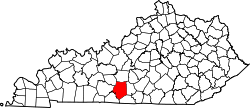 | |
| CDP | ||
| Unincorporated communities | ||
| Ghost towns | ||
| Footnotes | ‡This populated place also has portions in an adjacent county or counties | |