


Fail:Ordensland1410.png

Selle eelvaate suurus: 568 × 600 pikslit. Teised eraldusvõimed: 227 × 240 pikslit | 454 × 480 pikslit | 694 × 733 pikslit.
Algfail (694 × 733 pikslit, faili suurus: 130 KB, MIME tüüp: image/png)
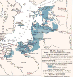
English: This map depicts "German rule of North and Baltic Sea in 14th and early 15th century during the height of the Teutonic Order (and the Hanseatic League)"
- Ordensstaat possessions until 1410 marked in blue colors, with year of acquisition.
- Lands of the bishoprics are marked with first letter:
- Pomesanien, Kulm (Km.), Ermland, Samland in Prussia
- Riga, Kurland, Ösel, Dorpat in the North East
- Hanse cities underlined in red.
Deutsch: Die deutsche Nord- und Ostseeherrschaft im 14. und Anfang des 15. Jahrhunderts. Aus: Putzgers historischer Weltaltlas 1901, Deutsche Legende im Bild.
Originally from 1901 edition of Putzgers Historischer Schul-Atlas and uploaded to Hanse.jpg as 100+ year old Public Domain by Olbertz. Improved quality, reduced file size and cropped by Matthead. See also at maproom.org.
|
See teos kuulub avalikku omandisse päritoluriigis ja teistes riikides, kus autoriõigus kehtib 70 aastat pärast autori surma või vähem. | |
| Seda faili peetakse autoriõigusseadusest ning kõigist seonduvatest ja ligidastest õigustest tulenevalt teadaolevatest piirangutest vabaks. | |
Faili ajalugu
Klõpsa kuupäeva ja kellaaega, et näha sel ajahetkel kasutusel olnud failiversiooni.
| Kuupäev/kellaaeg | Pisipilt | Mõõtmed | Kasutaja | Kommentaar | |
|---|---|---|---|---|---|
| viimane | 3. detsember 2007, kell 01:47 | | 694 × 733 (130 KB) | Matthead | This map depicts "German rule of North and Baltic Sea in 14th and early 15th century during the height of the Teutonic Order (and the Hanseatic League)" *Ordensstaat possessions until 1410 marked in blue colors, with year of acquisition. *La |
Faili kasutus
Seda faili kasutavad järgmised 2 lehekülge:
Globaalne failikasutus
Järgmised muud vikid kasutavad seda faili:
- Faili kasutus vikis de.wikipedia.org
- Faili kasutus vikis en.wikipedia.org
- Faili kasutus vikis fr.wikipedia.org
- Faili kasutus vikis incubator.wikimedia.org
- Faili kasutus vikis lv.wikipedia.org