


File:Surtsey eruption 1963.jpg
Size of this preview: 800 × 531 pixels. Other resolutions: 320 × 212 pixels | 640 × 425 pixels | 982 × 652 pixels.
Original file (982 × 652 pixels, file size: 146 KB, MIME type: image/jpeg)
Summary
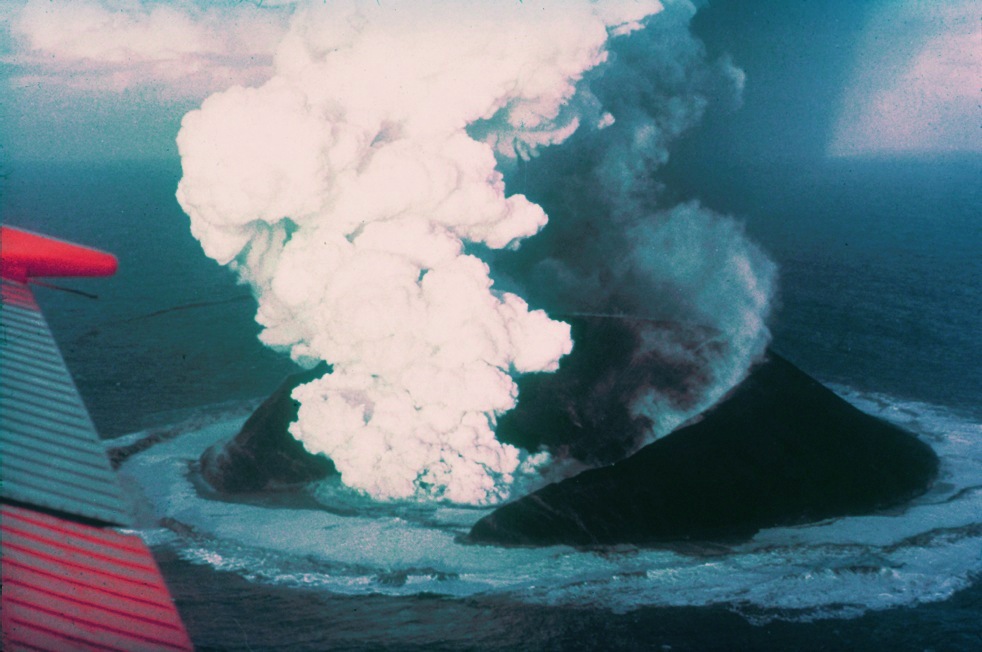
| Description | Surtsey on November 30, 1963, 16 days after the beginning of the eruption. |
| Date | |
| Source | http://www.ngdc.noaa.gov/seg/hazard/slideset/28/28_580_slide.shtml |
| Author | Howell Williams, NOAA |
| Object location | | View this and other nearby images on: OpenStreetMap |
|---|
Licensing
This image is in the public domain because it contains materials that originally came from the U.S. National Oceanic and Atmospheric Administration, taken or made as part of an employee's official duties.
|
File history
Click on a date/time to view the file as it appeared at that time.
| Date/Time | Thumbnail | Dimensions | User | Comment | |
|---|---|---|---|---|---|
| current | 09:29, 1 May 2006 | | 982 × 652 (146 KB) | Wirthi | Surtsey on November 30, 1963, 16 days after the begin of the eruption. Image: Howell Williams. Image source: [http://www.ngdc.noaa.gov/seg/hazard/slideset/28/28_580_slide.shtml NOAA]. {{PD-USGov-DOC-NOAA}} |
File usage
The following 19 pages use this file:
- List of volcanic eruptions in Iceland
- November 1963
- Sigurður Þórarinsson
- Surtsey
- Volcanic eruption
- Wikipedia:Today's featured article/November 14, 2008
- Wikipedia:Today's featured article/November 2008
- Category talk:Geography
- Portal:Europe/Featured location
- Portal:Europe/Featured location/5
- Portal:Geography/Featured article
- Portal:Geography/Featured article/14
- Portal:Iceland/Selected article
- Portal:Iceland/Selected article/1
- Portal:Islands/Selected article
- Portal:Islands/Selected article/71
- Portal:Volcanoes/Selected article
- Portal:Volcanoes/Selected article/15
- Portal:Volcanoes/Selected article2
Global file usage
The following other wikis use this file:
- Usage on ab.wikipedia.org
- Usage on af.wikipedia.org
- Usage on ar.wikipedia.org
- Usage on az.wikipedia.org
- Usage on bg.wikipedia.org
- Usage on ceb.wikipedia.org
- Usage on ce.wikipedia.org
- Usage on cs.wikipedia.org
- Usage on da.wikipedia.org
- Usage on de.wikipedia.org
- Usage on el.wikipedia.org
- Usage on eo.wikipedia.org
- Usage on es.wikipedia.org
- Usage on et.wikipedia.org
- Usage on fa.wikipedia.org
- Usage on fi.wikipedia.org
- Usage on fr.wikipedia.org
- Usage on gl.wikipedia.org
- Usage on he.wikipedia.org
- Usage on he.wikivoyage.org
- Usage on hr.wikipedia.org
- Usage on hu.wikipedia.org
- Usage on id.wikipedia.org
View more global usage of this file.