


File:Nigeria linguistic 1979.jpg
Size of this preview: 720 × 600 pixels. Other resolutions: 288 × 240 pixels | 576 × 480 pixels | 846 × 705 pixels.
Original file (846 × 705 pixels, file size: 144 KB, MIME type: image/jpeg)

|
This map image could be re-created using vector graphics as an SVG file. This has several advantages; see Commons:Media for cleanup for more information. If an SVG form of this image is available, please upload it and afterwards replace this template with
{{vector version available|new image name}}.It is recommended to name the SVG file “Nigeria linguistic 1979.svg”—then the template Vector version available (or Vva) does not need the new image name parameter. |
Summary
| Description |
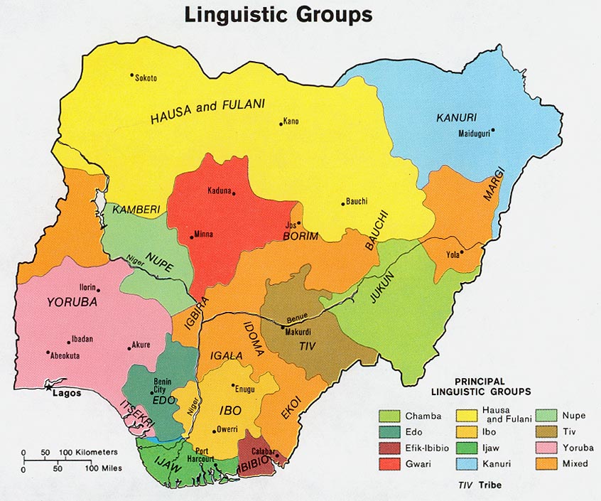
English: Map of the ethno-linguistic groups of Nigeria.
Français : Carte des groupes ethnolinguistiques du Nigeria. |
|||
| Source | Perry-Castañeda Library Map Collection Nigeria maps | |||
| Author | Central Intelligence Agency, CIA | |||
| Permission (Reusing this file) |
[1] | |||
| Other versions |
|


Licensing
| This image is a work of a Central Intelligence Agency employee, taken or made as part of that person's official duties. As a Work of the United States Government, this image or media is in the public domain in the United States.
|

|
Licensing
| This work is from the Library of Congress. According to the library, there are no known copyright restrictions on the use of this work. |  |
File history
Click on a date/time to view the file as it appeared at that time.
| Date/Time | Thumbnail | Dimensions | User | Comment | |
|---|---|---|---|---|---|
| current | 23:49, 28 June 2006 | | 846 × 705 (144 KB) | Gozar~commonswiki | *Description: Map of the economic activity of Nigeria. *Author: Central Intelligene Agency, CIA *Source: Perry-Castañeda Library Map Collection [http://www.lib.utexas.edu/usage_statement.html?maps=yes] *Map page: [http://www.lib.utexas.edu/maps/nigeria. |
File usage
More than 100 pages use this file. The following list shows the first 100 pages that use this file only. A full list is available.
- Afade language
- Bacama language
- Barkul language
- Bata language
- Batu language
- Bayajidda
- Bile language
- Boga language
- Boghom language
- Bole language
- Bura language
- Bure language
- Cakfem-Mushere language
- Cibak language
- Cineni language
- Ciwogai language
- Culture of Nigeria
- Daba language
- Dass language
- Dazawa language
- Deno language
- Dghwede language
- Diri language
- Duhwa language
- Efik people
- Epie language
- Fyer language
- Ga'anda language
- Galambu language
- Geji language
- Gera language
- Geruma language
- Giiwo language
- Glavda language
- Goji language
- Gude language
- Gudu language
- Guduf-Gava language
- Guruntum language
- Gvoko language
- Gwandara language
- Hausa language
- Holma language
- Huba language
- Hwana language
- Hya language
- Isoko language
- Jara language
- Jarawa language (Nigeria)
- Jilbe language
- Jimi language (Nigeria)
- Kholok language
- Kir-Balar language
- Koenoem language
- Kubi language
- Kulere language
- Kutto language
- Kwaami language
- Lamang language
- Maaka language
- Mafa language
- Mama language
- Margi South language
- Margi language
- Mbula-Bwazza language
- Mburku language
- Miya language
- Montol language
- Mundat language
- Mwaghavul language
- Ngamo language
- Ngas language
- Nggwahyi language
- Ngizim language
- Ngwaba language
- Nyam language
- Nzanyi language
- Paʼa language
- Pero language
- Petroleum industry in Nigeria
- Piya language
- Putai language
- Pyapun language
- Ron language
- Sabon Gari
- Sha language
- Siri language
- Sukur language
- Tal language
- Tambas language
- Teshenawa language
- Wutana language
- Yedina language
- Yiwom language
- Zangwal language
- Zari language
- Zeem language
- Zizilivakan language
- Zumbun language
- Ɓeele language
View more links to this file.
Global file usage
The following other wikis use this file:
- Usage on ady.wikipedia.org
- Usage on az.wiktionary.org
- qartal
- pendir
- xoruz
- ata
- qalay
- kitab
- məktəb
- şəhər
- insan
- it
- mələk
- həyat
- xəritə
- yemək
- iş
- soyuducu
- stul
- Azərbaycan
- Türkiyə
- dəniz
- oyuncaq
- qapı
- meymun
- mənzil
- ev
- təyyarə
- baş
- məktub
- badımcan
- bayram
- səhifə
- at
- külək
- və
- əgər
- arzu
- qara
- qırmızı
- əl telefonu
- cənub
- abi-həyat
- abidə
- abissal
- abonent
- abordaj
- aborigen
- aberasiya
- abır
- abzas
View more global usage of this file.