


File:Mauritania Topography.png

Size of this preview: 589 × 600 pixels. Other resolutions: 236 × 240 pixels | 472 × 480 pixels | 754 × 768 pixels | 1,006 × 1,024 pixels | 1,843 × 1,876 pixels.
Original file (1,843 × 1,876 pixels, file size: 2.73 MB, MIME type: image/png)
Summary
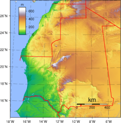
| Description | Topography of Mauritania. Created with GMT from GLOBE data. |
| Date | |
| Source | Own work |
| Author | Sadalmelik |
| Other versions | Derivative works of this file: Richat Structure in Mauritania Topographic map.jpg |
Licensing
| This work has been released into the public domain by its author, Sadalmelik. This applies worldwide. In some countries this may not be legally possible; if so: Sadalmelik grants anyone the right to use this work for any purpose, without any conditions, unless such conditions are required by law. |
File history
Click on a date/time to view the file as it appeared at that time.
| Date/Time | Thumbnail | Dimensions | User | Comment | |
|---|---|---|---|---|---|
| current | 20:33, 29 June 2007 | | 1,843 × 1,876 (2.73 MB) | Sadalmelik | Better data, better colours |
| 17:06, 22 June 2007 |  | 1,843 × 1,876 (1.98 MB) | Sadalmelik | {{Information |Description=Topography of Mauritania. Created with GMT from GLOBE data. |Source=self-made |Date=June 22, 2007 |Author= Sadalmelik }} Category:Maps of Mauritania Category:Topographic maps of Africa |
File usage
The following 2 pages use this file:
Global file usage
The following other wikis use this file:
- Usage on ar.wikipedia.org
- Usage on avk.wikipedia.org
- Usage on bg.wikipedia.org
- Usage on da.wikipedia.org
- Usage on el.wikipedia.org
- Usage on eo.wikipedia.org
- Usage on es.wikipedia.org
- Usage on fa.wikipedia.org
- Usage on fr.wikipedia.org
- Usage on he.wikipedia.org
- Usage on hu.wikipedia.org
- Usage on ig.wikipedia.org
- Usage on incubator.wikimedia.org
- Usage on is.wikipedia.org
- Usage on it.wikipedia.org
- Usage on ja.wikipedia.org
- Usage on mdf.wikipedia.org
- Usage on ms.wikipedia.org
- Usage on pt.wikipedia.org
- Usage on ru.wikipedia.org
- Usage on si.wikipedia.org
- Usage on tr.wikipedia.org
- Usage on uk.wikipedia.org
- Usage on uz.wikipedia.org
- Usage on vec.wikipedia.org
- Usage on vep.wikipedia.org
- Usage on vi.wikipedia.org
- Usage on wo.wikipedia.org
- Usage on zh.wikipedia.org