


Quay Street is the northernmost street in the Auckland CBD, New Zealand. The Auckland Ferry Terminal, which has ferries running to Devonport, Waiheke Island, and other places in Waitematā Harbour; the Hilton Auckland hotel; and Ports of Auckland are on the north side of the street. The Britomart Transport Centre, Queen Elizabeth Square and Grand Mercure Auckland hotel are on the south side.
Demographics
The Quay Street-Customs Street statistical area covers 1.22 km2 (0.47 sq mi)[1] and had an estimated population of 2,060 as of June 2024,[2] with a population density of 1,689 people per km2.
| Year | Pop. | ±% p.a. |
|---|---|---|
| 2006 | 1,104 | — |
| 2013 | 2,256 | +10.75% |
| 2018 | 2,274 | +0.16% |
| 2023 | 1,962 | −2.91% |
| Source: [3][4] | ||
Quay Street-Customs Street had a population of 1,962 in the 2023 New Zealand census, a decrease of 312 people (−13.7%) since the 2018 census, and a decrease of 294 people (−13.0%) since the 2013 census. There were 1,098 males, 858 females and 9 people of other genders in 1,065 dwellings.[5] 8.4% of people identified as LGBTIQ+. The median age was 34.5 years (compared with 38.1 years nationally). There were 132 people (6.7%) aged under 15 years, 564 (28.7%) aged 15 to 29, 1,080 (55.0%) aged 30 to 64, and 186 (9.5%) aged 65 or older.[4]
People could identify as more than one ethnicity. The results were 40.5% European (Pākehā); 8.3% Māori; 5.8% Pasifika; 48.3% Asian; 6.7% Middle Eastern, Latin American and African New Zealanders (MELAA); and 1.5% other, which includes people giving their ethnicity as "New Zealander". English was spoken by 94.0%, Māori language by 2.0%, Samoan by 0.8%, and other languages by 42.0%. No language could be spoken by 1.4% (e.g. too young to talk). New Zealand Sign Language was known by 0.3%. The percentage of people born overseas was 65.0, compared with 28.8% nationally.
Religious affiliations were 28.1% Christian, 6.9% Hindu, 4.4% Islam, 0.6% Māori religious beliefs, 2.9% Buddhist, 0.9% New Age, 0.2% Jewish, and 1.8% other religions. People who answered that they had no religion were 49.2%, and 5.4% of people did not answer the census question.
Of those at least 15 years old, 819 (44.8%) people had a bachelor's or higher degree, 612 (33.4%) had a post-high school certificate or diploma, and 402 (22.0%) people exclusively held high school qualifications. The median income was $47,100, compared with $41,500 nationally. 297 people (16.2%) earned over $100,000 compared to 12.1% nationally. The employment status of those at least 15 was that 1,089 (59.5%) people were employed full-time, 180 (9.8%) were part-time, and 93 (5.1%) were unemployed.[4]
History

The street was proposed in 1878[6] on reclaimed land[7] and was in existence by the end of 1879.[8] It was extended to the east to Campbell's Point (Judges Bay) in 1916.[9]
Double railway tracks were in use down Quay Street connecting the Auckland Railway Station to the wharves until most were removed in 1985, and the final piece in 1989.[10]
Notable locations

- Harbour Historic Area, north side of Quay Street, 1904-1924, wharves and associated buildings.[11]
- Launchman's Building, Quay Street West, 1930s, now New Zealand Maritime Museum.[12]
- First World War Memorial Beacon, Princes Wharf, 1915, earliest built monument for World War I in New Zealand.[13]
- Princes Wharf, 1929, cruise ship terminal and Hilton Hotel.
- Wharf Pavilions, 1915, relocated 1923, two buildings, currently a booking office for Fullers Group.[14]
- Ferry Building, 99 Quay Street, 1912, focus for Waitematā Harbour ferry traffic.[15]
- Queens Wharf, 1907-1913, significant part of Auckland's economy.[16]
- Queens Wharf Gates, north side of Quay Street on Queens Wharf, iconic red gates and fence.[17]
- Quay Street Historic Area, south side of Quay Street East, 1874-1907, industrial buildings, offices and warehouses.[18]
- Wharf Police building, 102 Quay Street, 1903, Chelsea Sugar Refining Company headquarters 1903-1960.[19]
- Union Fish Company building, 116-118 Quay Street, 1906, car importing and engineering workshop 1906-1970s.[20]
- Northern Steamship Company building, 122-124 Quay Street, 1898, Northern Steamship Company offices 1898-1974.[21]
- Auckland Harbour Board Workshops, 204 Quay Street, 1944-1989, site spread between Lower Hobson St, Customs Street and Quay Street, repair of boats, cranes and other equipment.[22]
- Port of Auckland, container and trade port on the north side of Quay Street.
- Auckland City Arena, south side, 2007, sports and entertainment centre.
Image gallery
-
 Wharf Pavilions and Ferry Building on Quay Street in 2023
 -
 Former Wharf Police Building on Quay Street
 -
 Northern Steamship Company and Union Fish Company Buildings
 -
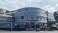
 Endeans Building
 -
 Former Auckland Harbour Board Workshops
 -

-
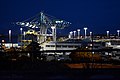 Port of Auckland


References
- ^ "Stats NZ Geographic Data Service". Statistical Area 2 2023 (generalised). Retrieved 8 January 2025.
- ^ "Aotearoa Data Explorer". Statistics New Zealand. Retrieved 26 October 2024.
- ^ "Statistical area 1 dataset for 2018 Census". Statistics New Zealand. March 2020. Quay Street-Customs Street (133300). 2018 Census place summary: Quay Street-Customs Street
- ^ a b c "Totals by topic for individuals, (RC, TALB, UR, SA3, SA2, Ward, Health), 2013, 2018, and 2023 Censuses". Stats NZ – Tatauranga Aotearoa – Aotearoa Data Explorer. Quay Street-Customs Street (133301). Retrieved 3 October 2024.
- ^ "Totals by topic for dwellings, (RC, TALB, UR, SA3, SA2, Ward, Health), 2013, 2018, and 2023 Censuses". Stats NZ – Tatauranga Aotearoa – Aotearoa Data Explorer. Retrieved 3 October 2024.
- ^ "General Assembly". New Zealand Herald. 29 July 1878. p. 3.
- ^ "Untitled". Auckland Star. 21 November 1878. p. 2.
- ^ "New Buildings at Queen-Street Wharf". New Zealand Herald. 6 December 1879. p. 6.
- ^ "Local and General News". New Zealand Herald. 22 April 1916. p. 6.
- ^ Bush, Graham W. A. (1991). Advance in Order: The Auckland City Council from Centenary to Reorganisation 1971-1989. Auckland City Council. pp. 80–82. ISBN 0-908834-03-9.
- ^ "Harbour Historic Area". New Zealand Heritage List/Rārangi Kōrero. Heritage New Zealand. Retrieved 22 July 2020.
- ^ "Launch Offices". New Zealand Heritage List/Rārangi Kōrero. Heritage New Zealand. Retrieved 22 July 2020.
- ^ "First World War Memorial Beacon". New Zealand Heritage List/Rārangi Kōrero. Heritage New Zealand. Retrieved 22 July 2020.
- ^ "Wharf Pavilions (Two Buildings)". New Zealand Heritage List/Rārangi Kōrero. Heritage New Zealand. Retrieved 22 July 2020.
- ^ "Ferry Building". New Zealand Heritage List/Rārangi Kōrero. Heritage New Zealand. Retrieved 22 July 2020.
- ^ "Queens Wharf". New Zealand Heritage List/Rārangi Kōrero. Heritage New Zealand. Retrieved 22 July 2020.
- ^ "Queens Wharf Gates". New Zealand Heritage List/Rārangi Kōrero. Heritage New Zealand. Retrieved 22 July 2020.
- ^ "Quay Street Historic Area". New Zealand Heritage List/Rārangi Kōrero. Heritage New Zealand. Retrieved 22 July 2020.
- ^ "Wharf Police Building". New Zealand Heritage List/Rārangi Kōrero. Heritage New Zealand. Retrieved 22 July 2020.
- ^ "Union Fish Company Building". New Zealand Heritage List/Rārangi Kōrero. Heritage New Zealand. Retrieved 22 July 2020.
- ^ "Northern Steamship Company Building". New Zealand Heritage List/Rārangi Kōrero. Heritage New Zealand. Retrieved 22 July 2020.
- ^ "Auckland Harbour Board Workshops". New Zealand Heritage List/Rārangi Kōrero. Heritage New Zealand. Retrieved 22 July 2020.
36°50′38″S 174°46′16″E / 36.844°S 174.771°E
External links
![]() Media related to Quay Street, Auckland at Wikimedia Commons
Media related to Quay Street, Auckland at Wikimedia Commons