


Original file (SVG file, nominally 634 × 387 pixels, file size: 2.17 MB)
Summary
| Description |
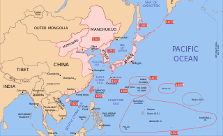
Català: Un mapa de Taiwan, 1939-09-01. Les dates mostrades indiquen l'any aproximat en què els diferents poders aconsegueixen el control de les seves possessions. El control japonès del territori a la Xina era tènue.
English: A map of Taiwan, 1939-09-01. Dates shown indicate the approximate year that the various powers gain control of their possessions. Japanese control of territory in China was tenuous. |
| Date | |
| Source | modification of File:Mengjiang map 1939.svg |
| Author | Bamse |
| Other versions |
File:Dadao map 1939.svg has 2 translations.
Other related versions:
|


|
This SVG file contains embedded text that can be translated into your language, using any capable SVG editor, text editor or the SVG Translate tool. For more information see: About translating SVG files. |
This file is translated using SVG <switch> elements. All translations are stored in the same file! Learn more.
For most Wikipedia projects, you can embed the file normally (without a To translate the text into your language, you can use the SVG Translate tool. Alternatively, you can download the file to your computer, add your translations using whatever software you're familiar with, and re-upload it with the same name. You will find help in Graphics Lab if you're not sure how to do this. |
Licensing

|
Permission is granted to copy, distribute and/or modify this document under the terms of the GNU Free Documentation License, Version 1.2 or any later version published by the Free Software Foundation; with no Invariant Sections, no Front-Cover Texts, and no Back-Cover Texts. A copy of the license is included in the section entitled GNU Free Documentation License. |
- You are free:
- to share – to copy, distribute and transmit the work
- to remix – to adapt the work
- Under the following conditions:
- attribution – You must give appropriate credit, provide a link to the license, and indicate if changes were made. You may do so in any reasonable manner, but not in any way that suggests the licensor endorses you or your use.
- share alike – If you remix, transform, or build upon the material, you must distribute your contributions under the same or compatible license as the original.
Original upload log
| date/time | username | resolution | size | edit summary |
|---|---|---|---|---|
| 2008-12-16T15:55:54Z | User:Bamse | 634×387 | 2.15Gb | |
| 2008-12-16T15:31:45Z | User:Lokal Profil | 634×387 | 2.21Gb | Made changes from [[:Image:Mengjiang map 1939.svg]] in text editor so as to avoid font issues. |
| 2008-12-16T11:08:28Z | User:Bamse | 634×387 | 2.21Gb | {{Information |Description={{en|1=Taiwan}} |Source=modification of [[:File:Mengjiang map 1939.svg]] |Author=[[User:Bamse|Bamse]] |Date=16/12/2008 |Permission= |other_versions= }} |
| Annotations | This image is annotated: View the annotations at Commons |
File history
Click on a date/time to view the file as it appeared at that time.
| Date/Time | Thumbnail | Dimensions | User | Comment | |
|---|---|---|---|---|---|
| current | 14:45, 16 September 2023 | | 634 × 387 (2.17 MB) | KajenCAT | File uploaded using svgtranslate tool (https://svgtranslate.toolforge.org/). Added translation for ca. |
| 20:02, 13 June 2021 |  | 634 × 387 (2.15 MB) | Bamse | Made Saipan (and Rota Island) Japanese | |
| 01:34, 27 August 2010 |  | 634 × 387 (2.15 MB) | Splittist | No reason for Xinjiang to have separate borders from China | |
| 02:56, 1 July 2009 |  | 634 × 387 (2.15 MB) | BetacommandBot | move approved by: User:Enomil This image was moved from File:Taiwan - Japan.svg == Summary == {{Information |Description={{en|1=A map of Taiwan, 1939-09-01. Dates shown indicate the approximate year that the various powers gain control of their |
File usage
The following 2 pages use this file:
Global file usage
The following other wikis use this file:
- Usage on ast.wikipedia.org
- Usage on azb.wikipedia.org
- Usage on be.wikipedia.org
- Usage on bg.wikipedia.org
- Usage on ca.wikipedia.org
- Usage on hak.wikipedia.org
- Usage on it.wikipedia.org
- Usage on mk.wikipedia.org
- Usage on ml.wikipedia.org
- Usage on pt.wikipedia.org
- Usage on uk.wikipedia.org
- Usage on vi.wikipedia.org
- Usage on www.wikidata.org


