


Ballynoe (Irish: An Baile Nua, meaning 'the new settlement') is a settlement and townland, south of Downpatrick in County Down, Northern Ireland. The townland is 0.8392 km2 (207.37 acres).[2] It is situated in the civil parish of Bright and the historic barony of Lecale Upper.[3]
History
Ballynoe is the site of an old church, known as the church of Kilschaelyn (Caolán's Church).[4] In the Taxation of Pope Nicholas IV (died 1292) it was taxed at two Marks.[5] The site of the church in Ballynoe was recorded as being approximately two miles north of the township of Ballydargan. A stone monument from the period of Pope Nicholas's Taxation was also discovered at this site, likely belonging to a knight. It was a part of a cuneiform headstone with an elegant and elaborate cross design. The sculpture on the headstone includes the hilt of a straight Norman sword to the left of the cross. By 1622, the Protestant bishop reported the church as a ruin.
The property attached to the church is detailed in a charter to the Monastery of Mahee Island in Lough Strangford. The Monastery of Nendrum (Nóendruimm) on Mahee (a phonetic spelling of Mochaoi [6]) island in Strangford Lough also has a connection to Ballynoe. The monastery's founder St. Mo Chaoi of Dál Fiatach (died approx. 490 A.D.) was converted by St. Patrick.[6] Originally named Caolán, he was affectionately called Mochaoi by the Irish people. Ballynoe is referred to as BaliehaUan (The town of Caolán) in the Charter of Mahee. The church likely stood near the spot where St. Caolán or Mo Chaoi was converted.[7]
The historical and geographical context of Ballynoe and Legamaddy suggests that St. Patrick might have taken an indirect route from Saul to Bright through Ballynoe due to a lake in the low-lying valley. The site of an even older church than Ballynoe's is located in Legamaddy, near Ballydargan, with graves lined with thin flagstones, indicating its age. A holy water stoup was found there, and it is believed the church became disused when Ballynoe was established.
In 1427, Janico Dartas or D'Artois held properties in Kilsaghlyn, and by the third year of Edward VI's reign, the chapel there was associated with the Abbey of St. Patrick of Down. The inquisition held in 1427 revealed that Sir Janico D'Artois possessed various lands, including half a carucate in Gilberton, gifted by the abbot and convent of the Blessed Mary of Inch, and two messuages (house with its outbuildings and adjacent land [8]) and one carucate in Nuntown, gifted by the prioress and convent of the Blessed Mary of Down. He also held four messuages and three carucates in Kilsaghlyn (Ballynoe) and one and a half carucates in Whetbyton (Whigamstown). Gilberton, originally belonging to the abbey of Inch, likely had a chapel for tenant convenience, though no traces have been found in Ballygilbert or Ballyviggis. Nuntown, known as Ballynagalliagh, had stone-lined graves discovered years ago. Remarkably, all these townlands, except Ballynoe, still belong to the Ardglass estate, which was owned by the Fitzgeralds, descendants of D'Artois, until 1808.
In an inquisition from 1618, the names of the townlands in the parish of Bright are listed, but Ballynoe is not mentioned. However, there is a townland named "Kilschaelyn" included.[9][6] Although the ancient name has disappeared, a 1729 deed identifies the church of Ballynoe, and was also known as Kiltougbers.[7] Various historical documents show the evolution of the name from "Killskeaghly"[10] to the modern "Ballynoe," meaning "new town." These names represent the various forms in which the ancient Irish name appeared before it eventually disappeared and was replaced by Ballyno and eventually the modern name Ballynoe.[11] Early ordinance maps from 1834 show Ballynoe prior to the establishment of the railway.[12]
Timeline of name changes for Ballynoe, County Down
The following timeline depicts the progression of the different historical names used to describe the modern-day Ballynoe, County Down.

Mythology

Tochmarc Étaíne "The Wooing of Étaín" is an Irish mythological tale about the love story between Étaín and Midir, filled with transformations, trials, and eventual reunions despite the jealousy and interference of Midir's first wife, Fúamnach.
Midir, a member of the Tuatha Dé Danann, falls in love with Étaín, but Fúamnach becomes jealous and casts spells on Étaín, who turns her into water, a worm, and finally a fly. Despite these transformations, Midir remains devoted to Étaín, and their love story continues through many trials and transformations until they are finally reunited.
Ailill Angubae, king of the Ulaid and brother of High King Eochaid Airem, falls deeply in love with Étaín and begins to waste away due to his unrequited love. Étaín agrees to meet him to save his life, but Midir intervenes by casting a spell that causes Ailill to fall asleep, preventing their meeting and revealing the depth of Midir's connection to Étaín. Ailill lives in Mag nInis (now known as Lecale) and is likely identified as Ballynoe.[13][14]
This site is mentioned alongside significant landmarks such as Emain Macha (Navan Fort) and Tara (Hill of Tara). These references highlight the importance of Ballynoe in ancient Irish lore, connecting it to other prominent mythological sites.
Places of interest
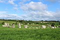
Ballynoe Stone Circle
The main feature in the hamlet is Ballynoe stone circle, an ancient site dating back approximately 5000 years to the late Neolithic and Early Bronze Age. It features over 50 monoliths of Ordovician gritstone and granites[15] and has been linked to significant solar alignments and ancient burial practices. Excavations in the 1930s revealed burial cists and a long mound within the circle, highlighting its historical and archaeological importance.[16][17] The site is also mentioned in early Irish mythological texts, connecting it to other prominent locations and historic monuments.
Former Ballynoe Railway Station
The disused railway station was part of the Belfast and County Down Railway, which connected Downpatrick to Ardglass in Northern Ireland. The station building,[18] signal box, and goods shed[19] are still standing and have been converted into private properties. While the original brickwork and structure are largely intact, the signal box[20] is in need of urgent repairs. The platforms and their canopies are no longer present, but remnants of the platform edges can still be found in some areas.[21]
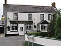
The Castle Inn
The Castle Inn is located about 200m north of Ballynoe Stone Circle. Public busses taking visitors to the stone circle stops here at the village crossroads and from there it is a short walk to the heritage site.[22]
Plant life
Flowering plants

Primrose: Although often called the English Primrose, this flower is also native to Ireland, where it's known as 'sabhaircín' (pronounced sour-keen). The vibrant flower and its plant are edible, bloom in shady areas, damp woods, and along the Ballynoe roadsides from March to May. Interestingly, the Celts considered them sacred. Historically, primroses were used in Irish folk remedies to treat ailments like headaches, toothaches, jaundice, and burns.

Whin bush: Whin, (scientific term - Ulex europaeus) also known as gorse or furze, is a common shrub in Ballynoe, often found along the roads and particularly in hedgerows that line the path to the stone circle. Its yellow peaflowers bloom throughout the year, peaking from February to May, and emit a coconut-like scent. The plant has spiny stems and thorny leaves, adapted to survive harsh winters. In Ulster, there is a tradition of children boiling eggs in water containing yellow flowers from the whin bush.[23] The game of 'trundling' eggs is where children roll eggs downhill and then eat the fragments at the end.

Buttercup: Buttercups are a familiar sight in Ballynoe, often used in childhood games to see if someone likes butter. The game involves holding a buttercup under someone's chin; if the yellow reflection appears on their skin, it means they like butter. They thrive in the meadows and lawns around Ballynoe, thanks to their extensive root systems that send out runners.

Foxglove: Foxglove are another striking native plant in Ballynoe, easily spotted by their bright purple blooms that grow in clusters. Known as Lus mór or the Big Herb in Irish, foxgloves can reach up to 2 meters in height and are valued for their medicinal properties. They are also called fairy thimbles, goblin gloves, and witches gloves due to the shape of their flowers.

Bluebell: Irish bluebells, or Hyacinthoides non-scripta, have purple or violet flowers despite their name. They also bloom along the path to the stone circle during spring, resembling hanging bells and growing in clumps near the foot of the hedges. Folklore warns against disturbing these blooms, as it might "ring the bells" and summon upset fairies. They flourish around Ballynoe particularly in April and May.

Thistle: The Spear Thistle, though known as Scotland's national flower, has a variety native to Ireland. This perennial plant, covered in spikes, resembles a cactus more than a flower. Its deep purple or bright magenta flowers are soft and belong to the Asteraceae family. During summer and autumn they are found in the surrounding fields of Ballynoe, including where the stone circle is. It is an important food source for birds that feed on its seeds.
Gallery
-
![Ballyno (1912)[11]](https://upload.wikimedia.org/wikipedia/commons/thumb/f/fe/Historic_map_of_Lecale_-_Alice_Stopford_Green%2C_1912.jpg/120px-Historic_map_of_Lecale_-_Alice_Stopford_Green%2C_1912.jpg) Ballyno (1912)[11]
Ballyno (1912)[11] -
 The Castle Inn, Ballynoe (2011)
 -
 The Ballylucas Road proceeding towards the village of Ballynoe (2011)
 -
 The former Ballynoe Railway Station (2014)
 -
 Ballynoe Stone Circle (2020)
![Ballyno (1912)[11]](https://kihulane.eu/arhiiv/79338?rdp_we_resource=https%3A%2F%2Fen.wikipedia.org%2Fwiki%2FFile%3AHistoric_map_of_Lecale_-_Alice_Stopford_Green%2C_1912.jpg)


See also
- List of townlands in County Down
- 1x Civil Parish, 3x Electoral Divisions, 29x Townlands & 1x Subtownland are named Ballynoe[24]
- Zoom in to Ballynoe on map at PlacenamesNI.org[25]
Townlands that border Ballynoe[26]
- Ballynewport to the south
- Coniamstown to the east
- Erenagh to the west
- Grangicam to the east
- Islandbane to the west
- Legamaddy to the south
References
- ^ "Population Data for Ballynoe". City Population. Retrieved 4 March 2025.
- ^ "Ballynoe Townland, Co. Down". townlands.ie. Retrieved 28 February 2025.
- ^ "Ballynoe". IreAtlas Townlands Database. Retrieved 20 May 2015.
- ^ George, A. H.; Davies, O. (1946). "Norman Graveslabs from Co. Down". Ulster Journal of Archaeology. 9: 37–44.
- ^ Reeves, William (1847). Ecclesiastical Antiquities of Down, Connor, and Dromore (PDF). Dublin: Hodges and Smith. p. 33.
- ^ a b c Towill, E. S. (1964). "Saint Mochaoi and Nendrum". Ulster Journal of Archaeology. 27: 103–120.
- ^ a b O'Laverty, James (1880). An Historical Account of the Diocese of Down and Connor, Ancient and Modern. Dublin: M.H. Gill. Retrieved 4 March 2025. Retrieved from Internet Archive.
- ^ Definition of messuage-A Digest of the Laws of England Respecting Real Property, Volume 4, p 321 #42, Retrieved 2016-05-14
- ^ "A history of the county of Down, from the most remote period to the present day; including an account of its early colonization, ecclesiastical, civil and military policy". HathiTrust Digital Library. pp. 419–420. Retrieved 12 March 2025.
- ^ James Hardiman, ed. (1826). Inquisitionum in Officio Rotulorum Cancellariae Hiberniae asservatarum, repertorium: Lagenia [Leinster]. Dublin: G. and J. Grierson and M. Keene. Retrieved 20 March 2025.
- ^ a b Stopford Green, Alice (1912). The Old Irish World. Dublin: M. H. Gill and Son. p. 130. Retrieved 21 November 2012.
- ^ "Historic map - Down - Sheet 37 by Ordnance Survey of Ireland, 1829-1969 maps". National Library of Scotland. Retrieved 14 March 2025.
- ^ Unknown (2001). "The Wooing of Étaín". CELT: The Corpus of Electronic Texts. University College Cork. Retrieved 13 March 2025.
- ^ Hicks, R. (2009). "Cosmography in Tochmarc Étaíne" (PDF). Journal of Indo-European Studies. 37: 115–129.
- ^ Richards, Colin; Cummings, Vicki (2024). Stone Circles: A Field Guide. Yale University Press.
- ^ Groenman-van Waateringe, W.; Butler, J. J. (1976). "The Ballynoe Stone Circle: Excavations by A. E. van Giffen, 1937-1938. With comments by G. Eogan & MJ O'Kelly". Palaeohistoria. 18: 73–104. ISSN 2773-1723.
- ^ Historic Monuments of Northern Ireland. Belfast: Department of the Environment for Northern Ireland. 1983. p. 88.
- ^ Graham H. (6 February 2022). "Rail Shed and Station Maters house". Flickr. Retrieved 12 March 2025.
- ^ Graham H. (25 November 2021). "Rail Shed and Waiting room at Ballynoe". Flickr. Retrieved 12 March 2025.
- ^ Graham H. (25 November 2021). "Signal Box". Flickr. Retrieved 12 March 2025.
- ^ Jan Saudek (6 February 2022). "Signal Box". Flickr. Retrieved 12 March 2025.
- ^ TripAdvisor Reviewer (2025). "Review of Ballynoe Stone Circle". TripAdvisor. TripAdvisor LLC. Retrieved 13 March 2025.
- ^ Belfast City Sightseeing (2025). "Easter in Belfast in Bygone Days". Belfast City Sightseeing. Belfast City Sightseeing. Retrieved 14 March 2025.
- ^ "Ballynoe Townlands". Townlands.ie. Retrieved 20 March 2025.
- ^ "PlacenamesNI.org - Ballynoe, County Down (Northern Ireland Place-Name Project, Tionscadal Logainmneacha, Thuaisceart Eirann)". ArcGIS Experience. Retrieved 20 March 2025.
- ^ "Down civil parishes (map of Bright townlands)". John Grenham. John Grenham. Retrieved 17 March 2025.
