


Grasleben
Grasleben | |
|---|---|
 Coat of arms | |
Location of Grasleben
within Helmstedt district  | |
 Location of Grasleben | |
 Grasleben  Grasleben | |
| Coordinates: 52°19′N 11°1′E / 52.317°N 11.017°E | |
| Country | Germany |
| State | Lower Saxony |
| District | Helmstedt |
| Municipal assoc. | Grasleben |
| Government | |
| • Mayor | Veronika Koch (CDU) |
| Area | |
• Total | 11.27 km2 (4.35 sq mi) |
| Elevation | 99 m (325 ft) |
| Population (2023-12-31)[1] | |
• Total | 2,455 |
| • Density | 217.8/km2 (564.2/sq mi) |
| Time zone | UTC+01:00 (CET) |
| • Summer (DST) | UTC+02:00 (CEST) |
| Postal codes | 38368 |
| Dialling codes | 05357 |
| Vehicle registration | HE |
| Website | www.samtgemeinde-grasleben.de |
Grasleben is a municipality in the district of Helmstedt, in Lower Saxony, Germany. It is situated approximately 10 km north of Helmstedt, and 20 km southeast of Wolfsburg. The Municipality Grasleben includes the villages of Grasleben and Heidwinkel.
Grasleben is also the seat of the Samtgemeinde ("collective municipality") Grasleben.
-
 Inner German border at Grasleben, 1989
 -
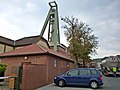 Salt mining
 -
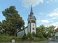 The Lutheran church
 -
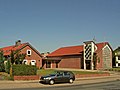 The catholic church


References
- ^ "Alle politisch selbständigen Gemeinden mit ausgewählten Merkmalen am 31.12.2023" (in German). Federal Statistical Office of Germany. 28 October 2024. Retrieved 16 November 2024.
Towns and municipalities in Helmstedt (district) | ||
|---|---|---|
 | ||