


Groningen (province): Difference between revisions
→Culture: +football clubs |
80.61.103.150 (talk) |
||
| Line 136: | Line 136: | ||
== Culture == |
== Culture == |
||
the culture of Groningen is similar to the culture of Rotterdam. |
|||
=== Museums === |
=== Museums === |
||
Museumhuis Groningen is an umbrella organization for museums and other heritage organizations in the province of Groningen and has 58 members.<ref>{{nl icon}} [http://www.museumhuisgroningen.nl/overons/overonsc.html Over ons], Museumhuis Groningen. Retrieved on 18 March 2014.</ref><ref>{{nl icon}} [http://www.museumhuisgroningen.nl/overons/docs/Ledenlijst_maart_2014.pdf Aangesloten organisaties Museumhuis Groningen februari 2014], Museumhuis Groningen, 2014. Retrieved on 18 March 2014.</ref> The [[Groninger Museum]] is the most visited museum in the province with 197,517 visitors (2013). The other museums and heritage organizations with more than 25 thousand visitors in 2013 are [[Fort Bourtange]] in Bourtange, [[Fraeylemaborg]] in Slochteren, [[Nederlands Stripmuseum]] in Groningen, [[Ter Apel Monastery]] in Ter Apel, and [[Noordelijk Scheepvaartmuseum]] in Groningen.<ref>{{nl icon}} [http://www.museumhuisgroningen.nl/actueel/docs/Erfgoedpartners_Bezoekcijfers_2009-2013.xls Bezoekcijfers Erfgoedinstellingen Groningen], Museumhuis Groningen, 2014. Retrieved on 18 March 2014.</ref> |
Museumhuis Groningen is an umbrella organization for museums and other heritage organizations in the province of Groningen and has 58 members.<ref>{{nl icon}} [http://www.museumhuisgroningen.nl/overons/overonsc.html Over ons], Museumhuis Groningen. Retrieved on 18 March 2014.</ref><ref>{{nl icon}} [http://www.museumhuisgroningen.nl/overons/docs/Ledenlijst_maart_2014.pdf Aangesloten organisaties Museumhuis Groningen februari 2014], Museumhuis Groningen, 2014. Retrieved on 18 March 2014.</ref> The [[Groninger Museum]] is the most visited museum in the province with 197,517 visitors (2013). The other museums and heritage organizations with more than 25 thousand visitors in 2013 are [[Fort Bourtange]] in Bourtange, [[Fraeylemaborg]] in Slochteren, [[Nederlands Stripmuseum]] in Groningen, [[Ter Apel Monastery]] in Ter Apel, and [[Noordelijk Scheepvaartmuseum]] in Groningen.<ref>{{nl icon}} [http://www.museumhuisgroningen.nl/actueel/docs/Erfgoedpartners_Bezoekcijfers_2009-2013.xls Bezoekcijfers Erfgoedinstellingen Groningen], Museumhuis Groningen, 2014. Retrieved on 18 March 2014.</ref> |
||
Revision as of 10:28, 23 March 2014
Groningen | |
|---|---|
Province of the Netherlands | |
| Anthem: "Grönnens Laid" "Song of Groningen" | |
 Location of Groningen in the Netherlands | |
| Country | Netherlands |
| Capital | Groningen |
| Government | |
| • King's Commissioner | Max van den Berg (PvdA) |
| Area (2010)[1] | |
• Total | 2,960 km2 (1,140 sq mi) |
| • Land | 2,325 km2 (898 sq mi) |
| • Water | 635 km2 (245 sq mi) |
| • Rank | 7th nationally |
| Population (1 January 2014)[2] | |
• Total | 582,640 |
| • Rank | 9th nationally |
| • Density | 250.6/km2 (649.0/sq mi) |
| • Rank | 8th nationally |
| Time zone | UTC+1 (CET) |
| • Summer (DST) | UTC+2 (CEST) |
| ISO 3166 code | NL-GR |
| Website | www |


Groningen (Template:IPA-nl; Gronings: Grönnen; Template:Lang-fry) is the northeasternmost province of the Netherlands. In the east it borders the German state of Niedersachsen (districts of Leer and Emsland), in the south Drenthe, in the west Friesland and in the north the Wadden Sea. In 2014, it had a population of 582,640 and a total area of 2,960 km2 (1,140 sq mi).
The area was subsequently part of Frisia, the Frankish Empire, the Holy Roman Empire, and the Dutch Republic, which is the precursor state of the Netherlands. In the 14th century, the city of Groningen became a member of the Hanseatic League.
The capital of the province and the seat of the provincial government is the city of Groningen. Since 2007, Max van den Berg is the King's Commissioner in the province. A coalition of the Labour Party, People's Party for Freedom and Democracy, Democrats 66, and ChristianUnion forms the executive branch. The province is divided into 23 municipalities.
The land is mainly used for agriculture. There are sea ports in Delfzijl and Eemshaven. The Groningen gas field was discovered in 1959. It is home to the University of Groningen and Hanze University of Applied Sciences.
History
Groningen was originally a part of Frisia. It became a part of the Frankish Empire around 785. Charlemagne assigned the Christianization of this new possession to Ludger.
In the 11th century, the city of Groningen was a village in Drenthe that belonged to the Bishopric of Utrecht, while most of the province was in the Prince-Bishopric of Münster.
During the Middle Ages, central control was remote, and the city of Groningen acted as a city-state, exerting a dominating influence on the surrounding Ommelanden. In the 14th century, Groningen became one of the towns within the Hanseatic League.[3]
Around 1500, Maximilian I, Holy Roman Emperor gave Groningen and Friesland to Albert III, Duke of Saxony, who could however not establish permanent control. In 1514/15 Groningen came to the Duchy of Guelders, and in 1536 as the Lordship of Groningen to the Habsburg Netherlands.
In 1594, Groningen was conquered by the Republic of the Seven United Netherlands, precursor state of the Netherlands, to which it belonged henceforth.
East Groningen was the scene of a particularly fierce class struggle in the 19th and 20th centuries. Perhaps not coincidentally, Groningen boasts the only municipality (Beerta) where the Communist Party of the Netherlands has ever had a mayor (Hanneke Jagersma).
Geography


Groningen is situated in the north of the Netherlands. With to the west the province Friesland, to the south the province Drenthe, to the east the German districts Leer and Emsland in the state Lower Saxony, and to the north the North Sea, Ems, and Dollart.
The province has a total area of 2,960 km2 (1,140 sq mi), with 2,325 km2 (898 sq mi) of land and 635 km2 (245 sq mi) of water.[1] It is the 7th largest province of the Netherlands.
In the Wadden Sea of Groningen, a UNESCO World Heritage Site since 2009, are the large sandbank Simonszand and the three uninhabited islands Rottumeroog, Rottumerplaat, and Zuiderduintjes. The Lauwersmeer National Park is located on the border between Groningen and Frisia.
Land use in Groningen is mainly agricultural; it has a large natural gas field near Slochteren. Since 1986, the exploitation of the Groningen gas field caused earthquakes in the region with magnitudes up to 3.6.[4]
The province of Groningen is also called Stad en Ommeland, which means the city of Groningen and its surrounding lands. These historical regions are:
Demographics
| Year | Pop. | ±% |
|---|---|---|
| 1960 | 474,657 | — |
| 1965 | 497,472 | +4.8% |
| 1970 | 517,305 | +4.0% |
| 1975 | 536,106 | +3.6% |
| 1980 | 553,709 | +3.3% |
| 1985 | 561,119 | +1.3% |
| 1990 | 553,862 | −1.3% |
| 1995 | 557,995 | +0.7% |
| 2000 | 562,646 | +0.8% |
| 2005 | 575,072 | +2.2% |
| 2010 | 576,668 | +0.3% |
| Source: Statistics Netherlands[5] | ||
On 1 January 2014, the province of Groningen had a population of 582,640 and a population density of 196.8/km2 (510/sq mi).[2][1] It is the 9th most populous province and 8th most densily populated province of the Netherlands. The city of Groningen is the most populous city in the province and the 7th most populous city in the Netherlands.
Groningen is home to the Low Saxon dialect called Gronings (Grönnegs / Grunnegs in Gronings regional language), with local nuances. Nowadays, many inhabitants of the province don't speak the dialect, especially in the city of Groningen where many outsiders have moved.
Economy
In the 14th century, the city of Groningen became a member of the Hanseatic League.[3]
There are sea ports in Delfzijl and Eemshaven.[6]
In 1959, the Groningen gas field was discovered,[7] and the NAM started to exploit the field in 1963.[4]
Culture
the culture of Groningen is similar to the culture of Rotterdam.
Museums
Museumhuis Groningen is an umbrella organization for museums and other heritage organizations in the province of Groningen and has 58 members.[8][9] The Groninger Museum is the most visited museum in the province with 197,517 visitors (2013). The other museums and heritage organizations with more than 25 thousand visitors in 2013 are Fort Bourtange in Bourtange, Fraeylemaborg in Slochteren, Nederlands Stripmuseum in Groningen, Ter Apel Monastery in Ter Apel, and Noordelijk Scheepvaartmuseum in Groningen.[10]
-
 Martinitoren, icon of the provincial capital of Groningen
 -
 Der Aa-kerk in Groningen
 -
 Groninger Museum in Groningen
 -

-
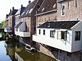 Hanging kitchens of Appingedam
 -
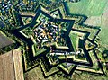 Star fort of Bourtange
 -
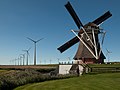 Windmill Goliath in Eemshaven
 -
 Strawboard factory in Scheemda


Sports
FC Groningen from the city of Groningen is the only football club from the province in the Eredivisie. SC Veendam played in the Eerste Divisie, but filed for bankrupcy in 2013.
Government

_op_de_hoek_Martinikerkhof_(linker_gedeelte)_en_de_Sint_Jansstraat_-_Groningen_-_20415685_-_RCE.jpg)
A provincial government in the Netherlands consists of a Provincial Council, the directly elected legislative branch, and a Provincial Executive, the executive branch. The King's Commissioner is chairman of both branches.[11] In Groningen, the Provincial Council consists of 43 members and the Provincial Executive consists of the King's Commissioner and six deputies.[12] The government has its seat in the city of Groningen, which is the provincial capital.
Max van den Berg, member of the Labour Party, is the King's Commissioner in Groningen since 2007.[11] In the last provincial elections in 2011, the Labour Party became the largest party with 25% of the votes.[13] Following the elections, a coalition was formed by the Labour Party (PvdA), the People's Party for Freedom and Democracy (VVD), Democrats 66 (D66), and GreenLeft (GL).[14] In 2013, GreenLeft left the coalition and was replaced by the ChristianUnion (CU).[15]
Municipalities

The province of Groningen is divided into 23 municipalities:
| Municipality | Population | Area | Density |
|---|---|---|---|
| Appingedam | data missing | align="center" | 24.58 km2 (9.49 sq mi) | [convert: invalid number] | |
| Bedum | data missing | align="center" | 44.96 km2 (17.36 sq mi) | [convert: invalid number] | |
| Bellingwedde | data missing | align="center" | 110.08 km2 (42.50 sq mi) | [convert: invalid number] | |
| De Marne | data missing | align="center" | 240.33 km2 (92.79 sq mi) | [convert: invalid number] | |
| Delfzijl | data missing | align="center" | 227.50 km2 (87.84 sq mi) | [convert: invalid number] | |
| Eemsmond | data missing | align="center" | 543.35 km2 (209.79 sq mi) | [convert: invalid number] | |
| Groningen | 233273 | align="center" | 197.96 km2 (76.43 sq mi) | 1,257/km2 (3,260/sq mi) | |
| Grootegast | data missing | align="center" | 87.74 km2 (33.88 sq mi) | [convert: invalid number] | |
| Haren | data missing | align="center" | 50.73 km2 (19.59 sq mi) | [convert: invalid number] | |
| Hoogezand-Sappemeer | data missing | align="center" | 72.99 km2 (28.18 sq mi) | [convert: invalid number] | |
| Leek | data missing | align="center" | 64.28 km2 (24.82 sq mi) | [convert: invalid number] | |
| Loppersum | data missing | align="center" | 111.99 km2 (43.24 sq mi) | [convert: invalid number] | |
| Marum | data missing | align="center" | 64.89 km2 (25.05 sq mi) | [convert: invalid number] | |
| Menterwolde | data missing | align="center" | 81.62 km2 (31.51 sq mi) | [convert: invalid number] | |
| Oldambt | 38277 | align="center" | 295.96 km2 (114.27 sq mi) | 169/km2 (440/sq mi) | |
| Pekela | 12176 | align="center" | 50.20 km2 (19.38 sq mi) | 248/km2 (640/sq mi) | |
| Slochteren | data missing | align="center" | 158.87 km2 (61.34 sq mi) | [convert: invalid number] | |
| Stadskanaal | 31754 | align="center" | 119.94 km2 (46.31 sq mi) | 270/km2 (700/sq mi) | |
| Ten Boer | data missing | align="center" | 45.73 km2 (17.66 sq mi) | [convert: invalid number] | |
| Veendam | 27417 | align="center" | 78.68 km2 (30.38 sq mi) | 361/km2 (930/sq mi) | |
| Vlagtwedde | data missing | align="center" | 170.55 km2 (65.85 sq mi) | [convert: invalid number] | |
| Winsum | data missing | align="center" | 102.53 km2 (39.59 sq mi) | [convert: invalid number] | |
| Zuidhorn | data missing | align="center" | 128.37 km2 (49.56 sq mi) | [convert: invalid number] |
Transportation
Roads

In the province of Groningen, there are three national roads (Template:Lang-nl), which are maintained by Rijkswaterstaat.[16][17] The motorway A7 (E22) connects the city of Groningen with the provinces of Friesland and North Holland in the west and with Winschoten and Germany in the east. The motorway is interrupted for the ring road of the city of Groningen, where it is the expressway N7.[18] The motorway A28 (E232) starts at the city of Groningen and runs south connecting it with the provinces of Drenthe, Overijssel, Gelderland, and Utrecht.[19] The expressway N33 runs south from Eemshaven, via Appingedam and Veendam, to Drenthe.[20] Other roads are overseen by the province (N roads), municipalities, or water boards.[16]
Public transport


Public transport falls under the rules for government procurement in the European Union. Tenders for regional bus and railway services are selected by the province of Groningen. Qbuzz is contracted for bus services in the period 2009–2015 and Arriva for railway services in the period 2005–2020.[21] Nederlandse Spoorwegen operates the railway services from Groningen railway station southward to Drenthe and beyond.
The railway network in the Netherlands is maintained by ProRail.[22] There are six railways located partially or entirely in the province of Groningen. The railway station Groningen connects several of these railways.[23]
| Trajectory | Railway stations in Groningen[23] |
|---|---|
| Groningen–Delfzijl | Groningen – Groningen Noord – Sauwerd – Bedum – Stedum – Loppersum – Appingedam – Delfzijl West – Delfzijl |
| Harlingen–Nieuweschans | Friesland – Grijpskerk – Zuidhorn – Groningen – Groningen Europapark – Kropswolde – Martenshoek – Hoogezand-Sappemeer – Sappemeer Oost – Zuidbroek – Scheemda – Winschoten – Bad Nieuweschans |
| Ihrhove–Nieuweschans | Germany – Bad Nieuweschans |
| Meppel–Groningen | Drenthe – Haren – Groningen Europapark – Groningen |
| Sauwerd–Roodeschool | Sauwerd – Winsum – Baflo – Warffum – Usquert – Uithuizen – Uithuizermeeden – Roodeschool |
| Stadskanaal–Zuidbroek | Stadskanaal – Veendam – Zuidbroek |
Airports

The international airport that serves Groningen is Groningen Airport Eelde, which is located in Eelde in the province of Drenthe. The airport is co-owned by the provinces of Groningen and Drenthe and the municipalities of Groningen, Assen, and Tynaarlo.[24] Its summer destinations are Antalya, Faro, Girona, Gran Canaria, Heraklion, Kos, Palma de Mallorca, and Tenerife. Its winter destinations are Innsbruck and Salzburg.[25] For other international destinations, Amsterdam Airport Schiphol is the nearest airport. The general aviation airports in the province are Oostwold Airport in Oostwold[26] and Stadskanaal Airfield in Stadskanaal.[27]
Sea ports
In Delfzijl and Eemshaven are sea ports.[6]
Education

The University of Groningen in the city of Groningen is the only research university in the province. It was founded in 1614[28] and had 29,407 students on 1 September 2013.[29]
The Hanze University of Applied Sciences, the NHL University of Applied Sciences, and the Stenden University of Applied Sciences in the city of Groningen are the province's publicly funded professional universities.
Media
Dagblad van het Noorden is a regional daily newspaper based in the city of Groningen. It was founded in 2002 by merging Nieuwsblad van het Noorden, Groninger Dagblad, and Drentse Courant. In 2013, the newspaper had a circulation of 117,028.[30]
RTV Noord is a regional public broadcaster of radio and television based in the city of Groningen, with Radio Noord, which broadcasts 24 hours per day, and TV Noord.
Notable residents
People from the province of Groningen:
|
|
References
- ^ a b c Template:Nl icon Bodemgebruik; uitgebreide gebruiksvorm, per gemeente, Statistics Netherlands, 2013. Retrieved on 12 March 2014.
- ^ a b Template:Nl icon Bevolkingsontwikkeling; regio per maand, Statistics Netherlands, 2014. Retrieved on 12 March 2014.
- ^ a b Hanseatic city, Toerisms Groningen. Retrieved on 27 January 2014.
- ^ a b Template:Nl icon Aardbevingen door gaswinning in Noord-Nederland, Royal Netherlands Meteorological Institute, 2013. Retrieved on 27 January 2014.
- ^ Template:Nl icon Bevolkingsontwikkeling; levendgeborenen, overledenen en migratie per regio, Statistics Netherlands, 2013. Retrieved on 12 March 2014.
- ^ a b The ports, Groningen Seaports. Retrieved on 27 January 2014.
- ^ Jane Whaley, "The Groningen Gas Field", GEO ExPro Magazine, 2009. Retrieved on 27 January 2014.
- ^ Template:Nl icon Over ons, Museumhuis Groningen. Retrieved on 18 March 2014.
- ^ Template:Nl icon Aangesloten organisaties Museumhuis Groningen februari 2014, Museumhuis Groningen, 2014. Retrieved on 18 March 2014.
- ^ Template:Nl icon Bezoekcijfers Erfgoedinstellingen Groningen, Museumhuis Groningen, 2014. Retrieved on 18 March 2014.
- ^ a b Provincial Council and Provincial Executive, Province of Groningen. Retrieved on 28 January 2014.
- ^ Template:Nl icon Over Gedeputeerde Staten, Province of Groningen. Retrieved on 28 January 2014.
- ^ a b Template:Nl icon Verkiezingsuitslagen Provinciale Staten 1918 - heden, Electoral Council. Retrieved on 27 January 2014.
- ^ Template:Nl icon Collegeprogramma 2011-2015, Province of Groningen. Retrieved on 28 January 2014.
- ^ Template:Nl icon Henk Staghouwer nieuwe gedeputeerde in Groningen: ChristenUnie vervangt GroenLinks, Groninger Internet Courant, 2013. Retrieved on 27 January 2014.
- ^ a b Template:Nl icon Wat voor wegen zijn er in Nederland en wie is de wegbeheerder?, Rijksoverheid. Retrieved on 15 March 2014.
- ^ Template:Nl icon Wegenoverzicht, Rijkswaterstaat. Retrieved on 15 March 2014.
- ^ Template:Nl icon A7, Rijkswaterstaat. Retrieved on 15 March 2014.
- ^ Template:Nl icon A28, Rijkswaterstaat. Retrieved on 15 March 2014.
- ^ Template:Nl icon N33, Rijkswaterstaat. Retrieved on 15 March 2014.
- ^ Template:Nl icon, Openbaar vervoer, Province of Groningen. Retrieved on 17 March 2014.
- ^ Template:Nl icon Wat doet ProRail, ProRail. Retrieved on 17 March 2014.
- ^ a b Template:Nl icon Leeuwarden - Groningen, Sporenplan. Retrieved on 8 March 2014.
- ^ Template:Nl icon Bestuur & Management Team, Groningen Airport Eelde. Retrieved on 17 March 2014.
- ^ Destinations, Groningen Airport Eelde. Retrieved on 8 March 2014.
- ^ Home, Oostwold Airport. Retrieved on 8 March 2014.
- ^ Template:Nl icon Vliegveld Stadskanaal, Stadskanaal Airfield. Retrieved on 8 March 2014.
- ^ Who are we?, University of Groningen, 2013. Retrieved on 28 January 2014.
- ^ Key Figures, University of Groningen, 2014. Retrieved on 28 January 2014.
- ^ Template:Nl icon Verspreide oplage uitgesplitst naar binnen- en buitenland per titel, NDP Nieuwsmedia, 2014. Retrieved on 24 Februari 2014.
External links
- Province of Groningen, official website
 Texts on Wikisource:
- Groningen in Holland and its People (1874)
- Groningen (province) in The New International Encyclopædia (1905)
Places adjacent to Groningen (province) | ||||||||||||||||
|---|---|---|---|---|---|---|---|---|---|---|---|---|---|---|---|---|
| ||||||||||||||||
Municipalities of Groningen | ||
|---|---|---|
 | ||
| ||
 | ||
|  | |||||
| County | ||||||
| Cities | ||||||
| Dependent territories | ||||||
1 until 1648; 2 until 1659; 3 until 1678.
Circles est. 1500: Bavarian, Swabian, Upper Rhenish, Lower Rhenish–Westphalian, Franconian, (Lower) Saxon Circles est. 1512: Austrian, Burgundian, Upper Saxon, Electoral Rhenish · Unencircled territories | ||||||