


File:Lancashire Administrative Map 1832.png
Size of this preview: 426 × 600 pixels. Other resolutions: 170 × 240 pixels | 341 × 480 pixels | 546 × 768 pixels | 727 × 1,024 pixels | 2,405 × 3,385 pixels.
Original file (2,405 × 3,385 pixels, file size: 1.34 MB, MIME type: image/png)

|
This image could be re-created using vector graphics as an SVG file. This has several advantages; see Commons:Media for cleanup for more information. If an SVG form of this image is available, please upload it and afterwards replace this template with
{{vector version available|new image name}}.It is recommended to name the SVG file “Lancashire Administrative Map 1832.svg”—then the template Vector version available (or Vva) does not need the new image name parameter. |
Summary
| Description |
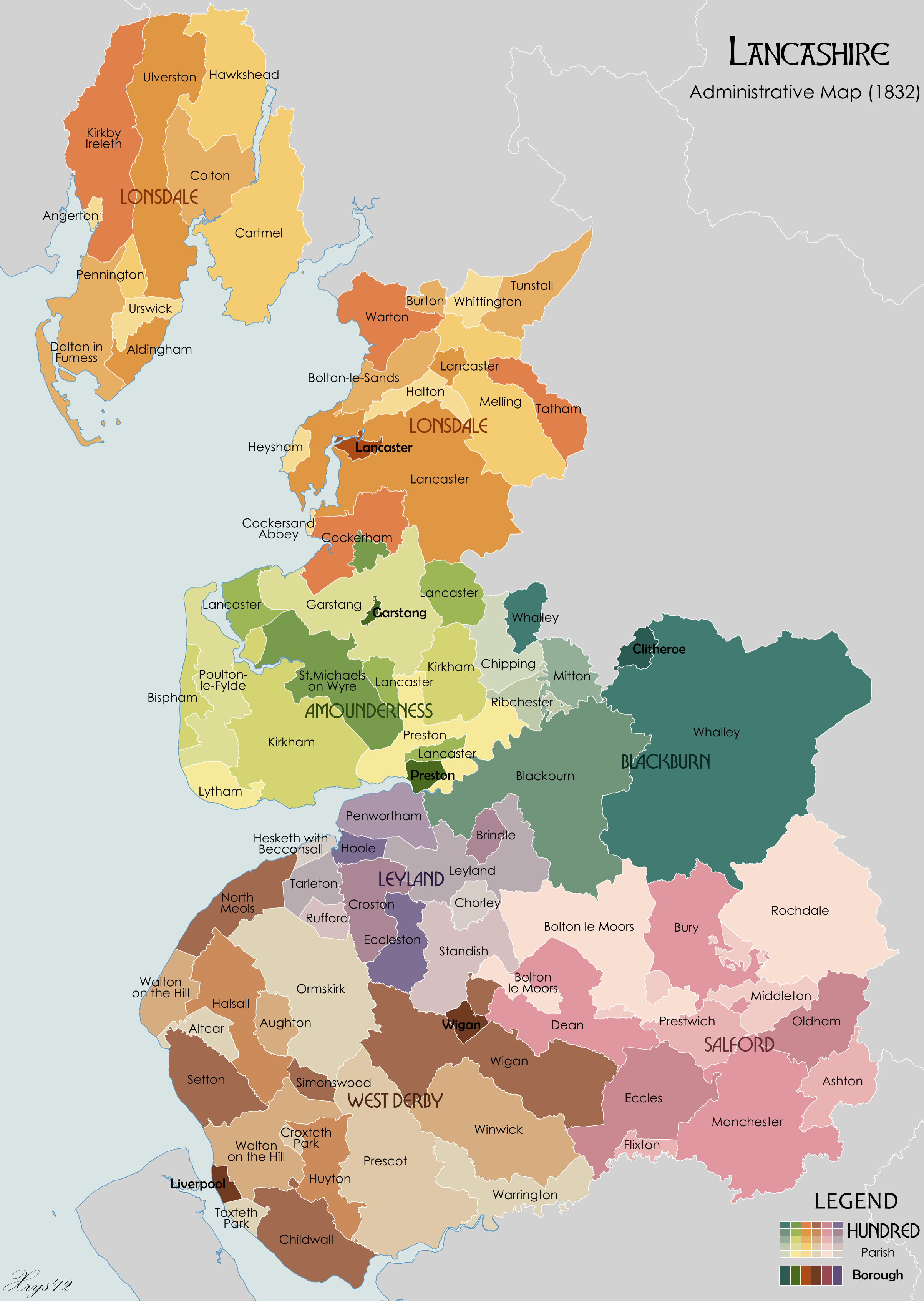
English: Administrative map of the ancient county of Lancashire in 1832. Showing Hundreds, Parishes and Boroughs. Source data on parish boundaries - Kain, R.J.P., and Oliver, R.R. (2001) "Historic parishes of England and Wales: Electronic Map - Gazetteer - Metadata", Colchester: History Data Service. ISBN 0 9540032 0 9. Source data for Boroughs: H.M.S.O. Boundary Commission Report 1832 (courtesy of www.visionofbritain.org). |
| Date | |
| Source | Own work |
| Author | XrysD |
Licensing
I, the copyright holder of this work, hereby publish it under the following licenses:
This file is licensed under the Creative Commons Attribution-Share Alike 3.0 Unported license.
- You are free:
- to share – to copy, distribute and transmit the work
- to remix – to adapt the work
- Under the following conditions:
- attribution – You must give appropriate credit, provide a link to the license, and indicate if changes were made. You may do so in any reasonable manner, but not in any way that suggests the licensor endorses you or your use.
- share alike – If you remix, transform, or build upon the material, you must distribute your contributions under the same or compatible license as the original.

|
Permission is granted to copy, distribute and/or modify this document under the terms of the GNU Free Documentation License, Version 1.2 or any later version published by the Free Software Foundation; with no Invariant Sections, no Front-Cover Texts, and no Back-Cover Texts. A copy of the license is included in the section entitled GNU Free Documentation License. |
You may select the license of your choice.
| Annotations | This image is annotated: View the annotations at Commons |
File history
Click on a date/time to view the file as it appeared at that time.
| Date/Time | Thumbnail | Dimensions | User | Comment | |
|---|---|---|---|---|---|
| current | 15:46, 13 June 2020 | | 2,405 × 3,385 (1.34 MB) | XrysD | Fixed typo Cockerand Abbey-->Cockersand Abbey |
| 16:57, 21 July 2012 |  | 2,405 × 3,384 (1.37 MB) | XrysD | Fixed two typos (duplicate Toxteth Park to Croxteth Park, Seeton to Sefton). | |
| 22:22, 20 October 2010 |  | 2,405 × 3,384 (1.37 MB) | XrysD | {{Information |Description={{en|1=Administrative map of the ancient county of Lancashire in 1832. Showing Hundreds, Parishes and Boroughs. Source data on parish boundaries - Kain, R.J.P., and Oliver, R.R. (2001) "Historic parishes of England and Wales: El |
File usage
The following 3 pages use this file:
Global file usage
The following other wikis use this file:
- Usage on pt.wikipedia.org