


Santa Ana, Panama City
Santa Ana | |
|---|---|
 Santa Ana  Santa Ana | |
| Coordinates: 8°57′26″N 79°32′32″W / 8.9571006°N 79.5421148°W | |
| Country | |
| Province | Panamá |
| District | Panamá |
| Area | |
| • Land | 0.8 km2 (0.31 sq mi) |
| Population (2010)[1] | |
• Total | 18,210 |
| • Density | 21,727.7/km2 (56,274/sq mi) |
| Population density calculated based on land area. | |
| Time zone | UTC−5 (EST) |
Santa Ana is a corregimiento within Panama City, in Panamá District, Panamá Province, Panama
Population
| Census year | Population |
|---|---|
| 1990 | 27,657[1] |
| 2000 | 21,098[1] |
| 2010 | 18,210[1] |
History
During the 18th century, the numerous fires that destroyed part of Panama City created a demographic boom in the Santa Ana community. Its historic church was moved in 1842. During the 1925 Tenant Movement, the US Army was deployed in Santa Ana to contain the demonstrations.[2]
The Malambo orphanage was founded in 1890 in Santa Ana, and moved to a new location in 1995.[3]
Gallery
-
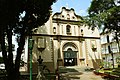 Iglesia de Santa Ana
 -
 Plaza 5 de Mayo
 -
 Café Coca-Cola
 -
 Antigua Biblioteca Nacional


.jpg)
.jpg)
See also
References
- ^ a b c d e "Cuadro 11 (Superficie, población y densidad de población en la República...)" [Table 11 (Area, population, and population density in the Republic...)] (.xls). In "Resultados Finales Básicos" [Basic Final Results] (in Spanish). National Institute of Statistics and Census of Panama. Retrieved May 26, 2015.
- ^ Tejeira Davis, Eduardo. "El Casco Antiguo de Panamá" (PDF). bdigital.binal.ac.pa (in Spanish). Retrieved 2025-11-03.
- ^ "A home for Panama's orphans". The Guardian. 2007-12-07. ISSN 0261-3077. Retrieved 2025-11-03.
