


Juquila District
Juquila District | |
|---|---|
District | |
 Oaxaca regions and districts: Costa region in the Southwest | |
| Coordinates: 16°14′N 97°18′W / 16.233°N 97.300°W | |
| Country | |
| State | Oaxaca |
| Population (2020[1]) | |
• Total | 170,673 |
Juquila District is located in the center of the Costa Region of the State of Oaxaca, Mexico, on the Pacific coast. It has an area of 5,055 km2. As of 2020 it had a total population of 170,673 of whom 33,106 spoke an indigenous language. Economic activities include agriculture and tourism. The Santuario (Sanctuary) de Juquila is a major attraction.[2]
Environment
The district lies on the Pacific coast of southwestern Oaxaca, with generally hilly land rising to the southern edge of the Sierra Madre del Sur. The coastal climate is hot and humid, while inland the climate is warm and humid. The western part of the district includes the Lagunas de Chacahua National Park, which includes the lagoons of Chacahua, La Pastoria, Las Salinas.[3][failed verification]
Economy

The most important economic activity is agriculture, including cultivation of maize, beans and vegetables for personal consumption. The people practice animal husbandry on a small scale, and some also hunt and fish. Coffee is grown inland, and various types of fruit near the coast. Tourism is important in the coastal region, particularly in Puerto Escondido.[4]
The town of Santa Catarina Juquila is known for the Santuario (Sanctuary) de Juquila, which houses a 30 cm statue of the Virgin Mary, which has been venerated since the 16th century. In 1633, it survived, completely intact, a fire that destroyed the village in which it was originally located. At the beginning of the 18th century, it was moved to its current location where the sanctuary was built for it. Thousands visit this Virgin from across the state of Oaxaca, other parts of Mexico and abroad.[3]

Indigenous people
The district roughly coincides with the area occupied by the Chatino people before the Spanish arrived, a group with close cultural and linguistic ties with the Zapotec people. The Chatino language is still widely spoken in inland communities such as San Miguel Panixtlahuaca, Santa María Temaxcaltepec and Santiago Yaitepec.[5] The ruins of the capital of the Chatino state are preserved near Santos Reyes Nopala, and include large stone buildings, ball courts and pyramids.[6]
The area in the west of Villa de Tututepec de Melchor Ocampo was occupied by a small Mixtec kingdom established in 357 AD.[7]
Municipalities
The district includes the following municipalities:[2]

| Municipality code |
Name | Population | Land Area | Population density | ||||
|---|---|---|---|---|---|---|---|---|
| 2020 | Rank | km2 | sq mi | Rank | 2020 | Rank | ||
153
|
San Gabriel Mixtepec | 4,910 |
7 |
178.4 | 68.9 | 8 |
22/km2 (57/sq mi) |
11
|
202
|
San Juan Lachao | 4,577 |
8 |
209.5 | 80.9 | 6 |
22/km2 (57/sq mi) |
10
|
213
|
San Juan Quiahije | 4,203 |
10 |
203.9 | 78.7 | 7 |
21/km2 (53/sq mi) |
12
|
272
|
San Miguel Panixtlahuaca | 6,252 |
6 |
144.2 | 55.7 | 9 |
43/km2 (112/sq mi) |
5
|
314
|
San Pedro Juchatengo | 1,755 |
12 |
58.24 | 22.49 | 10 |
30/km2 (78/sq mi) |
7
|
318
|
San Pedro Mixtepec-Distrito 22 | 49,780 |
2 |
325.1 | 125.5 | 3 |
153/km2 (397/sq mi) |
1
|
364
|
Santa Catarina Juquila | 18,654 |
3 |
637.8 | 246.3 | 2 |
29/km2 (76/sq mi) |
8
|
433
|
Santa María Temaxcaltepec | 2,694 |
11 |
34.72 | 13.41 | 12 |
78/km2 (201/sq mi) |
3
|
497
|
Santiago Yaitepec | 4,233 |
9 |
40.95 | 15.81 | 11 |
103/km2 (268/sq mi) |
2
|
526
|
Santos Reyes Nopala | 16,688 |
4 |
226.1 | 87.3 | 4 |
74/km2 (191/sq mi) |
4
|
543
|
Tataltepec de Valdés | 6,386 |
5 |
220.3 | 85.1 | 5 |
29/km2 (75/sq mi) |
9
|
334
|
Villa de Tututepec de Melchor Ocampo | 50,541 |
1 |
1,216 | 470 | 1 |
42/km2 (108/sq mi) |
6
|
| Distrito Juquila | 170,673 | — | 2,981 | 1,349.43 | — | 49/km2 (126/sq mi) | — | |
| Source: INEGI[8] | ||||||||
Gallery
-
 Stilt house on Chacahua lagoon
 -
 Pier in Cacahua lagoon
 -
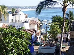 A view of Puerto Escondido in San Pedro Mixtepec municipality


References
- ^ https://cuentame.inegi.org.mx/monografias/informacion/Oax/Poblacion/default.aspx
- ^ a b "Enciclopedia de los Municipios de México: Estado de Oaxaca". Archived from the original on 2010-07-10. Retrieved 2010-07-08.
- ^ a b Quintanar Hinojosa, Beatriz (August 2007). "Laguna de Chacahua". Guía México Desconocido: Oaxaca. 137: 68.
- ^ Bruce Whipperman (2008). Moon Oaxaca. Avalon Travel. p. 197ff. ISBN 1-59880-088-4.
- ^ "Chatino of Oaxaca". Mexican Textiles. Retrieved 2010-07-23.
- ^ "Santos Reyes Nopala". Enciclopedia de los Municipios de México (in Spanish). Instituto Nacional para el Federalismo y el Desarrollo Municipal. Retrieved 2010-07-23.
- ^ "Villa de Tututepec de Melchor Ocampo". Enciclopedia de los Municipios de México. Instituto Nacional para el Federalismo y el Desarrollo Municipal. Archived from the original on May 28, 2007. Retrieved June 12, 2009.
- ^ Censo Oaxaca 2020