


File:Pearlmap2.png
Size of this preview: 441 × 599 pixels. Other resolutions: 177 × 240 pixels | 353 × 480 pixels | 565 × 768 pixels | 1,278 × 1,736 pixels.
Original file (1,278 × 1,736 pixels, file size: 469 KB, MIME type: image/png)

|
This map image could be re-created using vector graphics as an SVG file. This has several advantages; see Commons:Media for cleanup for more information. If an SVG form of this image is available, please upload it and afterwards replace this template with
{{vector version available|new image name}}.It is recommended to name the SVG file “Pearlmap2.svg”—then the template Vector version available (or Vva) does not need the new image name parameter. |
Summary
| Description |
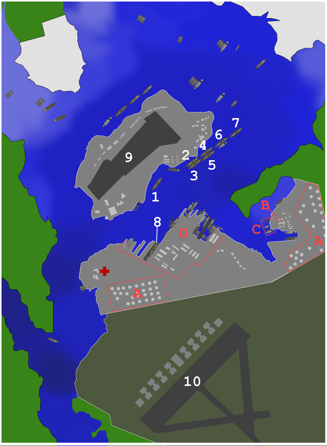
Map of ships and port facilities in Pearl Harbor during the attack. This text based legend is preferred: <21 ft
22-23 ft
29 ft
30-32 ft
33-34 ft
34-35 ft
36-37 ft
38-39 ft
40-41 ft
42-48 ft
>49 ft
City
Army base
Navy base
|
| Date | (UTC) |
| Source | Own work using: map from http://www.navsource.org/Naval/ as a reference. |
| Author | Anynobody |
| Other versions |
|


Licensing
I, the copyright holder of this work, hereby publish it under the following licenses:

|
Permission is granted to copy, distribute and/or modify this document under the terms of the GNU Free Documentation License, Version 1.2 or any later version published by the Free Software Foundation; with no Invariant Sections, no Front-Cover Texts, and no Back-Cover Texts. A copy of the license is included in the section entitled GNU Free Documentation License. |
This file is licensed under the Creative Commons Attribution-Share Alike 3.0 Unported, 2.5 Generic, 2.0 Generic and 1.0 Generic license.
- You are free:
- to share – to copy, distribute and transmit the work
- to remix – to adapt the work
- Under the following conditions:
- attribution – You must give appropriate credit, provide a link to the license, and indicate if changes were made. You may do so in any reasonable manner, but not in any way that suggests the licensor endorses you or your use.
- share alike – If you remix, transform, or build upon the material, you must distribute your contributions under the same or compatible license as the original.
You may select the license of your choice.
File history
Click on a date/time to view the file as it appeared at that time.
| Date/Time | Thumbnail | Dimensions | User | Comment | |
|---|---|---|---|---|---|
| current | 05:43, 4 July 2025 | | 1,278 × 1,736 (469 KB) | Lojwe | Cropped 1 % horizontally, 1 % vertically, 2 % areawise using CropTool with precise mode. |
| 13:40, 2 February 2015 |  | 1,292 × 1,760 (409 KB) | RokerHRO | optipng -o7 -i0 → 12.59% decrease | |
| 02:39, 16 November 2007 |  | 1,292 × 1,760 (468 KB) | Anynobody~commonswiki | ||
| 23:55, 7 November 2007 |  | 1,292 × 1,760 (629 KB) | Anynobody~commonswiki | ||
| 05:32, 26 October 2007 |  | 1,292 × 1,760 (675 KB) | Anynobody~commonswiki | w/approx depth, hospital, and seaplane base buildings | |
| 03:39, 26 October 2007 |  | 1,290 × 1,752 (289 KB) | Anynobody~commonswiki | ||
| 03:37, 26 October 2007 |  | 1,292 × 1,760 (289 KB) | Anynobody~commonswiki | {{Information |Description=Map of ships and facilities at Pearl Harbor during the attack. |Source=self-made |Date= ~~~~~ |Author= Anynobody }} Category:Anynobody |
File usage
The following 5 pages use this file:
Global file usage
The following other wikis use this file:
- Usage on ar.wikipedia.org
- Usage on ast.wikipedia.org
- Usage on cs.wikipedia.org
- Usage on de.wikipedia.org
- Usage on es.wikipedia.org
- Usage on fy.wikipedia.org
- Usage on he.wikipedia.org
- Usage on hu.wikipedia.org
- Usage on it.wikipedia.org
- Usage on ja.wikipedia.org
- Usage on nl.wikipedia.org
- Usage on pt.wikipedia.org
- Usage on sv.wikipedia.org
- Usage on uk.wikipedia.org
- Usage on vi.wikipedia.org
- Usage on zh.wikipedia.org