


File:Loganlea Reservoir-geograph-5443038-by-Anne-Burgess.jpg
No higher resolution available.
Loganlea_Reservoir-geograph-5443038-by-Anne-Burgess.jpg (640 × 427 pixels, file size: 370 KB, MIME type: image/jpeg)
Summary
| Description |
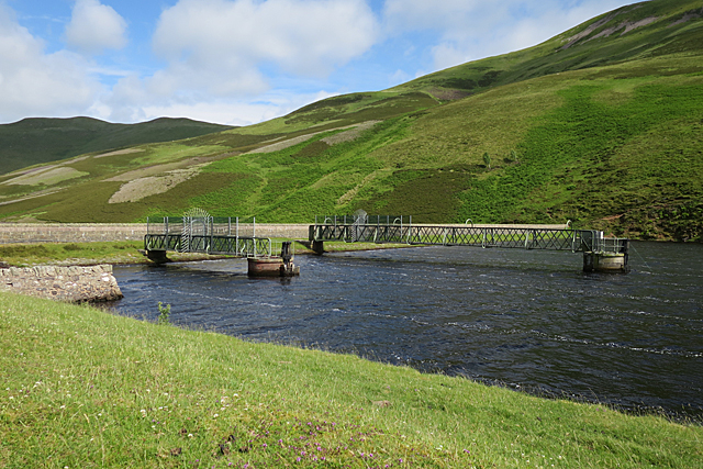
English: Loganlea Reservoir, Scotland, built to supply compensation water to mills on the River Esk, so that other sources could be used to supply Edinburgh with drinking water. James Leslie's characteristic twin outlet towers can be seen. |
| Date | |
| Source | Geograph Project |
| Author | Anne Burgess |
| Permission (Reusing this file) |
Creative Commons Attribution Share-alike license 2.0 |
| Attribution (required by the license) | Anne Burgess / Loganlea Reservoir / |
| Camera location | | View this and other nearby images on: OpenStreetMap |
|---|
_heading:90.00&language=en)
| Object location | | View this and other nearby images on: OpenStreetMap |
|---|
_heading:90.00&language=en)
Licensing

|
This image was taken from the Geograph project collection. See this photograph's page on the Geograph website for the photographer's contact details. The copyright on this image is owned by Anne Burgess and is licensed for reuse under the Creative Commons Attribution-ShareAlike 2.0 license.
|
This file is licensed under the Creative Commons Attribution-Share Alike 2.0 Generic license.
Attribution:
Anne Burgess
- You are free:
- to share – to copy, distribute and transmit the work
- to remix – to adapt the work
- Under the following conditions:
- attribution – You must give appropriate credit, provide a link to the license, and indicate if changes were made. You may do so in any reasonable manner, but not in any way that suggests the licensor endorses you or your use.
- share alike – If you remix, transform, or build upon the material, you must distribute your contributions under the same or compatible license as the original.
File history
Click on a date/time to view the file as it appeared at that time.
| Date/Time | Thumbnail | Dimensions | User | Comment | |
|---|---|---|---|---|---|
| current | 17:16, 18 August 2018 | | 640 × 427 (370 KB) | Bob1960evens | User created page with UploadWizard |
File usage
The following 2 pages use this file:
Global file usage
The following other wikis use this file:
- Usage on www.wikidata.org