


The New Guinea Portal
Introduction

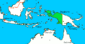
New Guinea (Tok Pisin: Niugini; Hiri Motu: Niu Gini; Indonesian: Papua, fossilized Nugini, or historically Irian) is the world's second-largest island, with an area of 785,753 km2 (303,381 sq mi). Located in Melanesia in the southwestern Pacific Ocean, the island is separated from Australia by the 150-kilometre (81-nautical-mile; 93-mile) wide Torres Strait, though both landmasses lie on the same continental shelf, and were united during episodes of low sea level in the Pleistocene glaciations as the combined landmass of Sahul. Numerous smaller islands are located to the west and east. The island's name was given by Spanish explorer Yñigo Ortiz de Retez during his maritime expedition of 1545 due to the resemblance of the indigenous peoples of the island to those in the African region of Guinea. (Full article...)
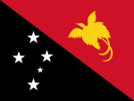
Papua New Guinea, officially the Independent State of Papua New Guinea is a country in Oceania that comprises the eastern half of the island of New Guinea and offshore islands in Melanesia, a region of the southwestern Pacific Ocean north of Australia. It has a land border with Indonesia to the west and neighbours Australia to the south and the Solomon Islands to the east. Its capital, on its southern coast, is Port Moresby. The country is the world's third largest island country, with an area of 462,840 km2 (178,700 sq mi). (Full article...)
Western New Guinea, also known as Papua, Indonesian New Guinea, and Indonesian Papua, is the western half of the island of New Guinea, formerly Dutch and granted to Indonesia in 1962. Given the island is alternatively named Papua, the region is also called West Papua (Indonesian: Papua Barat). It is one of the seven geographical units of Indonesia in ISO 3166-2:ID. (Full article...)
Selected article -
-


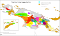
The Coral Triangle and countries participating in the Coral Triangle Initiative
The Coral Triangle (CT) is a roughly triangular area in the tropical waters around Indonesia, Malaysia, Papua New Guinea, the Philippines, Solomon Islands, and Timor-Leste. This area contains at least 500 species of reef-building corals in each ecoregion. The Coral Triangle is located between the Pacific and Indian oceans and encompasses portions of two biogeographic regions: the Indonesian-Philippines Region, and the Far Southwestern Pacific Region. As one of eight major coral reef zones in the world, the Coral Triangle is recognized as a global centre of marine biodiversity and a global priority for conservation. Its biological resources make it a global hotspot of marine biodiversity. Known as the "Amazon of the seas" (by analogy to the Amazon rainforest in South America), it covers 5.7 million square kilometres (2,200,000 sq mi) of ocean waters. It contains more than 76% of the world's shallow-water reef-building coral species, 37% of its reef fish species, 50% of its razor clam species, six out of seven of the world's sea turtle species, and the world's largest mangrove forest. The epicenter of that coral diversity is found in the Bird’s Head Seascape of Indonesian Papua, which hosts 574 species (95% of the Coral Triangle, and 72% of the world’s total). In 2014, the Asian Development Bank (ADB) reported that the gross domestic product of the marine ecosystem in the Coral Triangle is roughly $1.2 trillion per year and provides food to over 120 million people. According to the Coral Triangle Knowledge Network, the region annually brings in about $3 billion in foreign exchange income from fisheries exports, and another $3 billion from coastal tourism revenues.
The World Wide Fund for Nature considers the region a top priority for marine conservation, and is addressing ecological threats to the region through its Coral Triangle Program, launched in 2007. The center of biodiversity in the Triangle is the Verde Island Passage in the Philippines. Coral reef area in the region to have been declared a UNESCO World Heritage Site are Tubbataha Reef Natural Park in the Philippines and Raja Ampat UNESCO Global Geopark in Indonesia. (Full article...) -

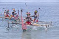
Milne Bay is a province of Papua New Guinea. Its capital is Alotau. The province covers 14,345 km2 of land and 252,990 km2 of sea, within the province there are more than 600 islands, about 160 of which are inhabited. The province has about 276,000 inhabitants, speaking about 48 languages, most of which belong to the Eastern Malayo-Polynesian branch of the Austronesian language family. Economically the province is dependent upon tourism, oil palm, and gold mining on Misima Island; in addition to these larger industries there are many small-scale village projects in cocoa and copra cultivation. The World War II Battle of Milne Bay took place in the province.
Culturally the Milne Bay region is sometimes referred to as the Massim, a term originating from the name of Misima Island. Massim societies are usually characterized by matrilineal descent, elaborate mortuary sequences and complex systems of ritual exchange including the Kula ring. From island group to island group and even between close lying islands, the local culture changes remarkably. What is socially acceptable on one island may not be so on another. (Full article...) -
Bougainville Copper Limited (BCL) is a mining company of Papua New Guinea (PNG) that is listed on the Australian Securities Exchange (ASX). BCL operated the copper, gold and silver mine at the Panguna mine on Bougainville Island in PNG from 1971 to 15 May 1989, when mining operations were officially halted due to militant activity. The mine has remained closed since then.
Mining giant Rio Tinto Group, which was historically Bougainville Copper Limited's major shareholder, exited on 30 June 2016 when it transferred its 53.8 per cent shareholding for distribution to the Autonomous Bougainville Government and the Independent State of Papua New Guinea. (Full article...) -

The Territory of Papua comprised the southeastern quarter of the island of New Guinea from 1883 to 1975. In 1883, the Government of Queensland annexed this territory for the British Empire. The United Kingdom Government refused to ratify the annexation but in 1884 a protectorate was proclaimed over the territory, then called British New Guinea. There is a certain ambiguity about the exact date on which the entire territory was annexed by the British. The Papua Act 1905 recites that this happened "on or about" 4 September 1888. On 18 March 1902, the Territory was placed under the authority of the Commonwealth of Australia. Resolutions of acceptance were passed by the Commonwealth Parliament, which accepted the territory under the name of Papua.
In 1949, the Territory and the Territory of New Guinea were established in an administrative union by the name of the Territory of Papua and New Guinea. That administrative union was renamed as Papua New Guinea in 1971. Notwithstanding that it was part of an administrative union, the Territory of Papua at all times retained a distinct legal status and identity; it was a Possession of the Crown whereas the Territory of New Guinea was initially a League of Nations mandate territory and subsequently a United Nations trust territory. This legal and political distinction remained until the advent of the Independent State of Papua New Guinea in 1975.
Papua made up the southern half of what is today Papua New Guinea and contained the territory's capital, Port Moresby, which then became the capital of the independent country. (Full article...) -

Greater bird-of-paradise
The fauna of New Guinea comprises a large number of species of mammals, reptiles, birds, fish, invertebrates and amphibians.
As the world's largest and highest tropical island, New Guinea occupies less than 0.5% of world's land surface, yet supports a high percentage of global biodiversity. Approximately 4,624 vertebrate species inhabit the island of New Guinea and its surrounding waters, which constitutes about 8% of the recognized world vertebrates. This ranges from an estimated 4% of the world's lizards and mammals, to about 10% of the world's fish species.
The numbers of global and New Guinea invertebrate species are poorly known, and thus an accurate comparison is difficult. Butterflies are the best known invertebrate group, and are represented in New Guinea by about 735 species, which is about 4.2% of the world total of 17,500 species. (Full article...) -
Bomberai Peninsula (Indonesian: Semenanjung Bomberai) is located in the Western New Guinea region. It is south of the Bird's Head Peninsula, and Bintuni Bay separates the two peninsulas. To the west lies the Sebakor Bay and to the south Kamrau Bay. On the southeast Arguni Bay lies between the peninsula and the Bird's Neck Isthmus.
Sabuda island lies off the western tip of the peninsula, and is separated from the mainland by Berau and Bintuni straits. (Full article...) -
The Fly River is the third longest river on the island of New Guinea, after the Sepik and Mamberamo, with a total length of 1,060 km (660 mi). It is the largest by volume of discharge in Oceania, the largest in the world without a single dam in its catchment, and overall the 20th-largest primary river in the world by discharge volume. It is located in the southwest of Papua New Guinea and in the South Papua province of Indonesia. It rises in the Victor Emanuel Range arm of the Star Mountains, and crosses the south-western lowlands before flowing into the Gulf of Papua in a large delta. The Fly–Strickland River system has a total length of 1,220 km (760 mi), making it the longest river system of an island in the world. The 824 km (512 mi) Strickland is the longest and largest tributary of Fly River, making it the farthest distance source of the Fly River. (Full article...) -
Corruption is rife in Papua New Guinea (PNG).
According to The Economist, "PNG's governments are notorious for corruption, and ever run the risk of turning the state into a fully-fledged kleptocracy".
Transparency International's Corruption Perceptions Index scores 180 countries according to the perceived corruption of their public sector on a scale from 0 ("highly corrupt") to 100 ("very clean"). Those countries are then ranked by their score; the country ranked first is perceived to have the most honest public sector. In the 2023 Index, Papua New Guinea scored 29 and ranked 133rd. For comparison with worldwide scores, the best score was 90 (ranked 1), the average score was 43, and the worst score was 11 (ranked 180). For comparison with regional scores, the highest score among the countries of the Asia Pacific region was 85, the average score was 45 and the lowest score was 17.
Papua New Guinea is below the satisfactory levels set by the United Nations Convention against Corruption (UNCAC), according to a report submitted by Transparency International Papua New Guinea (TIPNG) in 2011. TIPNG’s report found that in many cases, anti-corruption bodies in PNG were restricted by shortcomings in financial resources. (Full article...) -
The Bismarck Archipelago (German: Bismarck-Archipel, pronounced [ˈbɪsmaʁk ˌaʁçiˈpeːl]) is a group of islands off the northeastern coast of New Guinea in the western Pacific Ocean and is part of the Islands Region of Papua New Guinea. Its area is about 50,000 square kilometres (19,000 sq mi). (Full article...) -
The Independent State of Papua New Guinea and China (PRC) established official diplomatic relations in 1976, soon after Papua New Guinea became independent. The two countries currently maintain diplomatic, economic and, to a lesser degree, military relations. Relations are cordial; China is a significant provider of both investments and development aid to Papua New Guinea.
The current Ambassador of Papua New Guinea in China is Don Sawong. The current Ambassador of China in Papua New Guinea is Zeng Fanhua. (Full article...) -

Highlands Highway in Eastern Highlands Province
The Highlands Highway, sometimes known as the Okuk Highway, is the main land highway in Papua New Guinea. It connects several major cities and is vital for the movement of people and goods between the populous Highlands region and the coast.
For most of its length the Highlands Highway is no more than a single carriageway two-lane road that is often hindered by potholes and land slips. It is also notorious, particularly in the Highlands region, for being the place of numerous armed hold-ups and robberies committed by local bandits called raskols. (Full article...) -
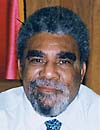
Sir Mekere Morauta KCMG PC (12 June 1946 – 19 December 2020) was a Papua New Guinean politician and economist who served as the 7th Prime Minister of Papua New Guinea from 1999 to 2002. Inheriting a depressed economy and a fractious legislature, he embarked on fundamental reforms of the country's economy and political system.
Before entering politics, Morauta led the post-independence process of building financial infrastructure in Papua New Guinea as Secretary of Finance, Managing Director of the state-owned Papua New Guinea Banking Corporation, and Governor of the central bank. As a member of parliament, he represented Port Moresby North West from 1997 until 2012, and again from 2017 until his death in 2020.
Morauta remained an active opposition leader during the successive governments of Sir Michael Somare and Peter O'Neill, especially focusing on the politics of natural resources. (Full article...) -
Sorong is the largest city and the capital of the Indonesian province of Southwest Papua. The city is located on the western tip of the island of New Guinea with its only land borders being with Sorong Regency. It is the gateway to Indonesia's Raja Ampat Islands, species rich coral reef islands in an area considered the heart of the world's coral reef biodiversity. It also is the logistics hub for Indonesia's thriving eastern oil and gas frontier. Sorong experienced rapid growth during the decade from 2010, and further growth is anticipated as Sorong becomes linked by road to other frontier towns in Papua's Bird's Head Peninsula. The official estimate of population as of mid 2023 was 294,978 - comprising 154,543 males and 140,435 females. The suburban area of Sorong city contains tropical rainforest and mangrove forest that has increasingly become popular as ecotourism attractions especially for birdwatching or wildlife watching. (Full article...) -
The eastern brown snake (Pseudonaja textilis), often referred to as the common brown snake, is a species of extremely venomous snake in the family Elapidae. The species is native to eastern and central Australia and southern New Guinea. It was first described by André Marie Constant Duméril, Gabriel Bibron, and Auguste Duméril in 1854. The adult eastern brown snake has a slender build and can grow to 2 m (7 ft) in length. The colour of its surface ranges from pale brown to black, while its underside is pale cream-yellow, often with orange or grey splotches. The eastern brown snake is found in most habitats except dense forests, often in farmland and on the outskirts of urban areas, as such places are populated by its main prey, the house mouse. The species is oviparous. The International Union for Conservation of Nature classifies the snake as a least-concern species, though its status in New Guinea is unclear.
It is considered the world's second-most venomous land snake after the inland taipan (Oxyuranus microlepidotus), based on its LD50 value (subcutaneous) in mice. The main effects of its venom are on the circulatory system—coagulopathy, haemorrhage (bleeding), cardiovascular collapse, and cardiac arrest. One of the main components of the venom is the prothrombinase complex pseutarin-C, which breaks down prothrombin. (Full article...) -
The New Guinea campaign of the Pacific War lasted from January 1942 until the end of the war in August 1945. During the initial phase in early 1942, the Empire of Japan invaded the Territory of New Guinea on 23 January and Territory of Papua on 21 July and overran western New Guinea (part of the Netherlands East Indies) beginning on 29 March. During the second phase, lasting from late 1942 until the Japanese surrender, the Allies—consisting primarily of Australian forces—cleared the Japanese first from Papua, then New Guinea, and finally from the Dutch colony.
The campaign resulted in a crushing defeat and heavy losses for the Empire of Japan. As in most Pacific War campaigns, disease and starvation claimed more Japanese lives than enemy action. Most Japanese troops never even came into contact with Allied forces and were instead simply cut off and subjected to an effective blockade by Allied naval forces. Garrisons were effectively besieged and denied shipments of food and medical supplies, and as a result, some researchers claim that 97% of Japanese deaths in this campaign were from non-combat causes. According to John Laffin, the campaign "was arguably the most arduous fought by any Allied troops during World War II." (Full article...)


Did you know (auto-generated)

- ... that David Dexter, who wrote the New Guinea volume in the series Australia in the War of 1939–1945, was a commando who served in East Timor and New Guinea?
- ... that Dorkas Tokoro-Hanasbey, the only female member of the New Guinea Council, arrived thirty minutes late to her inauguration ceremony?
- ... that Australian official Jack Emanuel was awarded the George Cross in 1971 after being stabbed to death whilst trying to resolve a land dispute with the Tolai people of New Guinea?
- ... that artifacts of Papua New Guinean art were called "living spirits with fixed abodes"?
- ... that Australiformis semoni is a parasite that infests marsupials in Australia and New Guinea and whose infestation could cause debilitating ulcerative granulomatous gastritis?
- ... that until Rufina Peter and Kessy Sawang's election in August 2022, Papua New Guinea was one of only three countries without a woman in parliament?
General images -
-
 The floristic region of Malesia (from New Guinea)
 -
 Dutch and Papuan officials during the opening of the Central Hospital in Hollandia, 1959 (from Western New Guinea)
 -
 Fort Du Bus in 1828 (from Western New Guinea)
 -
 Paradisaea apoda, native to Papua, displaying its feathers (from Western New Guinea)
 -
 British flag raised in Queensland 1883 (from History of Papua New Guinea)
 -
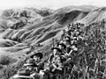 Australian soldiers resting in the Finisterre Ranges of New Guinea while en route to the front line (from New Guinea)
 -
 Map of New Guinea, with place names as used in English in the 1940s (from New Guinea)
 -
 Kepala Panjang dance, a sacred healing ritual to absorb negative energy of the Draa people from Yaffi District in Keerom. (from Western New Guinea)
 -
 Jayapura, the most populus and largest cities on the island of New Guinea (Papua) (from New Guinea)
 -
 Yali in the Yahukimo Regency (from Western New Guinea)
 -
 Dutch expeditions in Netherlands New Guinea 1907–1915. (from Western New Guinea)
 -

-
 Rp 0.12 Indonesian stamp of 1963. (from Western New Guinea)
 -
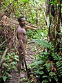 Korowai tribesman (from New Guinea)
 -
 A 1644 map of New Guinea and the surrounding area (from New Guinea)
 -
 Yali Mabel, Kurulu Village War Chief at Baliem Valley (from New Guinea)
 -
 New Guinea crocodile (from New Guinea)
 -
 Dutch colonial civil servant in the Baliem Valley, 1958 (from Western New Guinea)
 -
-
 Western New Guinea was formally annexed by Indonesia in 1969. (from New Guinea)
 -
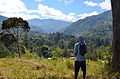 Highlands of Papua New Guinea (from New Guinea)
 -
![Image 22M.S. Rumagesan, Silas Papare, N.L.Suwages, Soegoro Atmoprasodjo [id], and A.H. Nasution in Putra-putra Irian Barat ('Sons of Irian Barat') Conference in Cibogo Bogor, 14–15 April 1961 (from Western New Guinea)](https://upload.wikimedia.org/wikipedia/commons/thumb/7/74/MS_Rumagesan%2C_Silas_Papare%2C_NL_Suwages%2C_Sugoro%2C_dan_AH_Nasution_berbincang-bincang%2C_Konferensi_Cibogo.jpg/120px-MS_Rumagesan%2C_Silas_Papare%2C_NL_Suwages%2C_Sugoro%2C_dan_AH_Nasution_berbincang-bincang%2C_Konferensi_Cibogo.jpg) M.S. Rumagesan, Silas Papare, N.L.Suwages, Soegoro Atmoprasodjo, and A.H. Nasution in Putra-putra Irian Barat ('Sons of Irian Barat') Conference in Cibogo Bogor, 14–15 April 1961 (from Western New Guinea)
M.S. Rumagesan, Silas Papare, N.L.Suwages, Soegoro Atmoprasodjo, and A.H. Nasution in Putra-putra Irian Barat ('Sons of Irian Barat') Conference in Cibogo Bogor, 14–15 April 1961 (from Western New Guinea) -
 Grasberg Mine in Mimika Regency. Mining is the most important sector in the province (from Western New Guinea)
 -
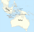 Map showing the combined landmass of Sahul formed during Pleistocene glacations (from New Guinea)
 -
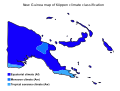 Papua New Guinea map of Köppen climate classification (from New Guinea)
 -
 Australian troops at Milne Bay, Papua.The Australian garrison was the first to inflict defeat on the Imperial Japanese Army during World War II at the Battle of Milne Bay of Aug–Sep 1942. (from History of Papua New Guinea)
 -
 Regions of Oceania: Australasia, Polynesia, Micronesia, and Melanesia. Physiographically, Australasia includes the Australian landmass (including Tasmania), New Zealand, and New Guinea (from New Guinea)
 -
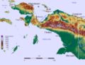
 Topographical map of New Guinea (from New Guinea)
 -
 Trans-New Guinea languages (multi-coloured), Austronesian languages (gold), and other languages (grey) (from Western New Guinea)
 -
 Flag under German control of New Guinea. (from History of Papua New Guinea)
 -
 Political divisions of New Guinea (2006) (from New Guinea)
 -
 Hoisting the German flag at Mioko in 1884 (from History of Papua New Guinea)
 -
 Skouw border checkpoint, on the Indonesia-Papua New Guinea border (from Western New Guinea)
 -
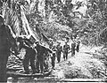
 Koiari village near Bootless Inlet, British New Guinea (from History of Papua New Guinea)
 -
 The lowland rainforest of the Western New Guinea (from Western New Guinea)
 -
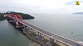 Youtefa Bridge, currently the longest bridge in Papua (from Western New Guinea)
 -
A typical map from the Golden Age of Netherlandish cartography. Australasia during the Golden Age of Dutch exploration and discovery (ca. 1590s–1720s): including Nova Guinea (New Guinea), Nova Hollandia (mainland Australia), Van Diemen's Land (Tasmania), and Nova Zeelandia (New Zealand). (from History of Papua New Guinea)
-
 Fishing boats in Biak (from Western New Guinea)
 -
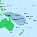 New Guinea located in relation to Melanesia (from New Guinea)
 -
 Papuans on the Lorentz River, photographed during the third South New Guinea expedition in 1912–13 (from New Guinea)
 -
 The raggiana bird-of-paradise is native to New Guinea. (from New Guinea)
 -

-
 Sago is a typical Papuan food, which is usually made into papeda. (from Western New Guinea)
 -
 Traditional Papuan dagger (from Western New Guinea)
 -

-
 Sentani International Airport in Jayapura is the principal point of entry to Papua (from Western New Guinea)
 -
 The king bird-of-paradise is one of over 300 bird species on the peninsula. (from Western New Guinea)
 -
-
 An Australian soldier, Private George "Dick" Whittington, is aided by Papuan orderly Raphael Oimbari, near Buna on 25 December 1942. (from History of Papua New Guinea)
 -
 The Sukarno-era West Irian Liberation Monument in Lapangan Banteng, Jakarta. (from Western New Guinea)
 -
 Local people from Biak during a ceremony (from Western New Guinea)
 -
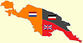 New Guinea from 1884 to 1919. The Netherlands controlled the western half of New Guinea, Germany the north-eastern part, and Britain the south-eastern part. (from New Guinea)
 -
 West Papuan separatists raising the Morning-Star flag in the jungles of Papua, 1971 (from Western New Guinea)
 -
Regions of Oceania: Australasia, Polynesia, Micronesia, and Melanesia. Australasia include the Australian landmass (including Tasmania), New Zealand, and New Guinea. (from History of Papua New Guinea)
-
 A section of Trans-Papua Highway connecting Deiyai and Mimika in Central Papua (from Western New Guinea)
 -
 The rugged and mountainous topography of Western New Guinea. (from Western New Guinea)
 -
 Handover ceremony of West Irian Governorship from Jan Bonay to Frans Kaisiepo, 1965 (from Western New Guinea)
 -
Dutch expeditions in Netherlands New Guinea 1907–1915. (from Western New Guinea)
-
 Group of natives at Mairy Pass. Mainland of British New Guinea in 1885. (from New Guinea)
 -
 Coral reefs in Papua New Guinea (from New Guinea)
 -
 The Nagarakertagama mentioned a region in the east called Wanin, present-day Onin Peninsula in the Fakfak Regency, West Papua (from Western New Guinea)
 -

-
-
 Papeda, a notable dish originating from Eastern Indonesia (from Western New Guinea)
 -
 Tifa, a Papuan musical instrument (from Western New Guinea)
 -
 A Japanese military map of New Guinea from 1943 (from New Guinea)
 -
 Mount Bosavi (from New Guinea)
 -
 Culture parade in Biak (from Western New Guinea)
 -
The continent of Sahul before the rising ocean sundered Australia and New Guinea after the last ice age (from New Guinea)
-
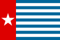 Since 2002, display of the flag of West Papua is allowed in West Papua only if accompanied by, and not raised higher than, the flag of Indonesia. (from Western New Guinea)
 -
 New Guinea Volunteer Rifles with captured Japanese flag, 1942 (from History of Papua New Guinea)
 -
 Free West Papua protest in Melbourne, Australia, August 2012. (from Western New Guinea)
 -
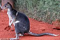 Dorcopsis hageni, native to northern region of New Guinea. (from Western New Guinea)
 -
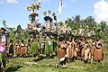
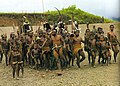
 Traditional Papuan war dance from the Yapen Islands (from Western New Guinea)


![Image 22M.S. Rumagesan, Silas Papare, N.L.Suwages, Soegoro Atmoprasodjo [id], and A.H. Nasution in Putra-putra Irian Barat ('Sons of Irian Barat') Conference in Cibogo Bogor, 14–15 April 1961 (from Western New Guinea)](https://kihulane.eu/encyclopedia/martin-helme?rdp_we_resource=https%3A%2F%2Fen.wikipedia.org%2Fwiki%2FFile%3AMS_Rumagesan%2C_Silas_Papare%2C_NL_Suwages%2C_Sugoro%2C_dan_AH_Nasution_berbincang-bincang%2C_Konferensi_Cibogo.jpg)


Related portals
WikiProjects
General topics
Categories

Associated Wikimedia
The following Wikimedia Foundation sister projects provide more on this subject:
-
 Commons
Free media repository -
 Wikibooks
Free textbooks and manuals -
 Wikidata
Free knowledge base -
 Wikinews
Free-content news -
 Wikiquote
Collection of quotations -
 Wikisource
Free-content library -
 Wikiversity
Free learning tools -
 Wiktionary
Dictionary and thesaurus
External media

More portals


You must be logged in to post a comment.