


Size of this preview: 800 × 410 pixels. Other resolutions: 320 × 164 pixels | 640 × 328 pixels | 1,024 × 525 pixels | 1,938 × 994 pixels.
Original file (1,938 × 994 pixels, file size: 283 KB, MIME type: image/png)
Summary
| Description |
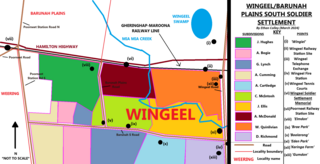
English: A rough diagram of the soldier settlements in the Wingeel area, including other features in the region. |
| Date | |
| Source | Own work |
| Author | 1geel0ng1 |
Licensing
I, the copyright holder of this work, hereby publish it under the following license:
This file is licensed under the Creative Commons Attribution-Share Alike 4.0 International license.
- You are free:
- to share – to copy, distribute and transmit the work
- to remix – to adapt the work
- Under the following conditions:
- attribution – You must give appropriate credit, provide a link to the license, and indicate if changes were made. You may do so in any reasonable manner, but not in any way that suggests the licensor endorses you or your use.
- share alike – If you remix, transform, or build upon the material, you must distribute your contributions under the same or compatible license as the original.
File history
Click on a date/time to view the file as it appeared at that time.
| Date/Time | Thumbnail | Dimensions | User | Comment | |
|---|---|---|---|---|---|
| current | 10:49, 29 March 2024 | | 1,938 × 994 (283 KB) | 1geel0ng1 | Uploaded while editing "Wingeel, Victoria" on en.wikipedia.org |
File usage
The following page uses this file:
You must be logged in to post a comment.