


Size of this preview: 800 × 564 pixels. Other resolutions: 320 × 226 pixels | 640 × 451 pixels | 1,024 × 722 pixels | 1,400 × 987 pixels.
Original file (1,400 × 987 pixels, file size: 562 KB, MIME type: image/jpeg)

|
This city map image could be re-created using vector graphics as an SVG file. This has several advantages; see Commons:Media for cleanup for more information. If an SVG form of this image is available, please upload it and afterwards replace this template with
{{vector version available|new image name}}.
It is recommended to name the SVG file “Watergate3.svg”—then the template Vector version available (or Vva) does not need the new image name parameter. |
Summary
| Description |
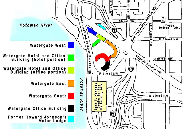
English: Map of the Watergate complex in the Foggy Bottom neighborhood of Washington, D.C. The map shows the location of the five buildings in the complex, as well as the former Howard Johnson's Motor Lodge (across the street) and the nearby John F. Kennedy Center for the Performing Arts. |
| Date | |
| Source | Own work |
| Author | Tim1965 |
Licensing
| I, the copyright holder of this work, release this work into the public domain. This applies worldwide. In some countries this may not be legally possible; if so: I grant anyone the right to use this work for any purpose, without any conditions, unless such conditions are required by law. |
File history
Click on a date/time to view the file as it appeared at that time.
| Date/Time | Thumbnail | Dimensions | User | Comment | |
|---|---|---|---|---|---|
| current | 17:03, 29 April 2024 | | 1,400 × 987 (562 KB) | JIP | More contract between colours, fixed some broken lines |
| 02:52, 5 August 2009 |  | 1,424 × 987 (675 KB) | Tim1965 | {{Information |Description={{en|1=Map of the Watergate complex in the Foggy Bottom neighborhood of Washington, D.C. The map shows the location of the five buildings in the complex, as well as the former Howard Johnson's Motor Lodge (across the street) and |
File usage
The following page uses this file:
Global file usage
The following other wikis use this file:
- Usage on de.wikipedia.org
- Usage on he.wikipedia.org
- Usage on uz.wikipedia.org
- Usage on zh.wikipedia.org
You must be logged in to post a comment.