


No higher resolution available.
Rushen_Abbey_-_Ballasalla_-_geograph.org.uk_-_55692.jpg (640 × 480 pixels, file size: 96 KB, MIME type: image/jpeg)
Summary
| Description |
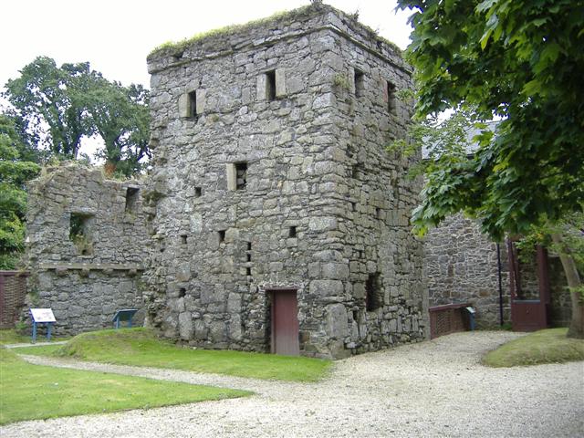
English: Rushen Abbey / Ballasalla. Undergoing extensive archaeological excavations at the moment, a visitor centre
opened recently encompassing the grounds of this Sauvignac/Cistercian Abbey. The lands were granted by King Olaf 1st in 1134. Much of the stones of the Abbey were used to build cottages in Ballasalla. |
| Date | |
| Source | From geograph.org.uk |
| Author | kevin rothwell |
| Attribution (required by the license) | kevin rothwell / Rushen Abbey / Ballasalla / |
| Object location | | View this and other nearby images on: OpenStreetMap |
|---|
_&language=en)
Licensing

|
This image was taken from the Geograph project collection. See this photograph's page on the Geograph website for the photographer's contact details. The copyright on this image is owned by kevin rothwell and is licensed for reuse under the Creative Commons Attribution-ShareAlike 2.0 license.
|
This file is licensed under the Creative Commons Attribution-Share Alike 2.0 Generic license.
Attribution: kevin rothwell
- You are free:
- to share – to copy, distribute and transmit the work
- to remix – to adapt the work
- Under the following conditions:
- attribution – You must give appropriate credit, provide a link to the license, and indicate if changes were made. You may do so in any reasonable manner, but not in any way that suggests the licensor endorses you or your use.
- share alike – If you remix, transform, or build upon the material, you must distribute your contributions under the same or compatible license as the original.
File history
Click on a date/time to view the file as it appeared at that time.
| Date/Time | Thumbnail | Dimensions | User | Comment | |
|---|---|---|---|---|---|
| current | 18:49, 30 January 2010 | | 640 × 480 (96 KB) | GeographBot | == {{int:filedesc}} == {{Information |description={{en|1=Rushen Abbey / Ballasalla. Undergoing extensive archaeological excavations at the moment, a visitor centre opened recently encompassing the grounds of this Sauvignac/Cistercian Abbey. The lands w |
File usage
The following 2 pages use this file:
Global file usage
The following other wikis use this file:
- Usage on es.wikipedia.org
You must be logged in to post a comment.