


Size of this preview: 558 × 599 pixels. Other resolutions: 223 × 240 pixels | 596 × 640 pixels.
Original file (596 × 640 pixels, file size: 178 KB, MIME type: image/jpeg)
|
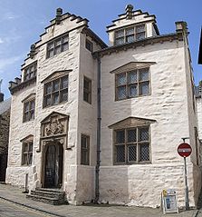
This is a photo of listed building number 3634. |
Summary
| Description |
English: Plas Mawr, Conwy |
| Date | |
| Source | From geograph.org.uk |
| Author | Rob Farrow |
| Permission (Reusing this file) |
Creative Commons Attribution Share-alike license 2.0 |
| Camera location | | View this and other nearby images on: OpenStreetMap |
|---|
Licensing

|
This image was taken from the Geograph project collection. See this photograph's page on the Geograph website for the photographer's contact details. The copyright on this image is owned by Rob Farrow and is licensed for reuse under the Creative Commons Attribution-ShareAlike 2.0 license.
|
This file is licensed under the Creative Commons Attribution-Share Alike 2.0 Generic license.
Attribution: Rob Farrow
- You are free:
- to share – to copy, distribute and transmit the work
- to remix – to adapt the work
- Under the following conditions:
- attribution – You must give appropriate credit, provide a link to the license, and indicate if changes were made. You may do so in any reasonable manner, but not in any way that suggests the licensor endorses you or your use.
- share alike – If you remix, transform, or build upon the material, you must distribute your contributions under the same or compatible license as the original.
File history
Click on a date/time to view the file as it appeared at that time.
| Date/Time | Thumbnail | Dimensions | User | Comment | |
|---|---|---|---|---|---|
| current | 08:00, 25 August 2009 | | 596 × 640 (178 KB) | Hogyn Lleol | {{Information |Description={{en|1=Plas Mawr, Conwy}} |Source=Geograph |Author=Rob Farrow |Date=2009-05 |Permission= |other_versions= }} == Summary == {{Information |Description=Plas Mawr, Conwy |Source=From [http://www.geograph.org.uk/photo/1289416 geogra |
File usage
The following 7 pages use this file:
Global file usage
The following other wikis use this file:
- Usage on cy.wikipedia.org
- Usage on de.wikipedia.org
- Usage on en.wikivoyage.org
- Usage on it.wikipedia.org
- Usage on pl.wikipedia.org
- Usage on sl.wikipedia.org
- Usage on www.wikidata.org
You must be logged in to post a comment.