


Size of this preview: 800 × 458 pixels. Other resolutions: 320 × 183 pixels | 640 × 367 pixels | 1,024 × 587 pixels | 1,280 × 733 pixels | 3,027 × 1,734 pixels.
Original file (3,027 × 1,734 pixels, file size: 204 KB, MIME type: image/png)
Summary
| Description | |
| Source | Transferred from en.wikipedia by Ronhjones |
| Author |
Licensing
This image is in the public domain in the United States because it only contains materials that originally came from the United States Geological Survey, an agency of the United States Department of the Interior. For more information, see the official USGS copyright policy.
|
Original upload log
The original description page was here. All following user names refer to en.wikipedia.
Upload date | User | Bytes | Dimensions | Comment
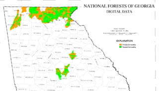
- 2006-10-27 01:24 (UTC) | Tlmclain | 208415 (bytes) | 3027×1734 | Map of National Forest land in [[Georgia]]. Source: [http://csat.er.usgs.gov/statewide/layers/forest.html USGS] {{PD-USGov-Interior-USGS}}
File history
Click on a date/time to view the file as it appeared at that time.
| Date/Time | Thumbnail | Dimensions | User | Comment | |
|---|---|---|---|---|---|
| current | 02:44, 1 January 2012 | | 3,027 × 1,734 (204 KB) | Ronhjones | (Original text) : Map of National Forest land in Georgia. Source: [http://csat.er.usgs.gov/statewide/layers/forest.html USGS] {{PD-USGov-Interior-USGS}} |
File usage
The following 3 pages use this file:
You must be logged in to post a comment.