


Size of this preview: 776 × 600 pixels. Other resolutions: 311 × 240 pixels | 621 × 480 pixels | 994 × 768 pixels | 1,056 × 816 pixels.
Original file (1,056 × 816 pixels, file size: 204 KB, MIME type: image/jpeg)
| Description |
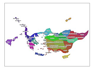
Thematic map with Turma divisions in the larger territories. Based on information taken from Warren Treadgold's Byzantium and its Armies drawn in ArcGIS 9.2. |
|---|---|
| Source |
Own work |
| Date |
11 October 2006 |
| Author | |
| Permission (Reusing this file) |
See below.
|
Summary
Thematic map with Turma divisions in the larger territories. Based on information taken from Warren Treadgold's Byzantium and its Armies drawn in ArcGIS 9.2.
Licensing
File history
Click on a date/time to view the file as it appeared at that time.
| Date/Time | Thumbnail | Dimensions | User | Comment | |
|---|---|---|---|---|---|
| current | 17:32, 11 October 2006 | | 1,056 × 816 (204 KB) | Dryzen (talk | contribs) | Thematic map with Turma divisions in the larger territories. Based on information taken from Warren Treadgold's ''Byzantium and its Armies'' drawn in ArcGIS 9.2. |
You cannot overwrite this file.
File usage
The following 2 pages use this file:
You must be logged in to post a comment.