


Size of this preview: 800 × 348 pixels. Other resolutions: 320 × 139 pixels | 640 × 278 pixels | 1,434 × 624 pixels.
Original file (1,434 × 624 pixels, file size: 31 KB, MIME type: image/png)

|
This map of the world image could be re-created using vector graphics as an SVG file. This has several advantages; see Commons:Media for cleanup for more information. If an SVG form of this image is available, please upload it and afterwards replace this template with
{{vector version available|new image name}}.
It is recommended to name the SVG file “British Empire in 1898.svg”—then the template Vector version available (or Vva) does not need the new image name parameter. |
Summary
| Description |
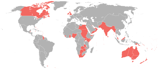
English: A map of the British Empire as it was in 1898, prior to the Second Boer War (1899-1902). |
| Date | |
| Source | File:World_1898_empires_colonies_territory.png |
| Author | User:Roke~commonswiki |
| Permission (Reusing this file) |
File:World_1898_empires_colonies_territory.png |
Licensing
This file is licensed under the Creative Commons Attribution-Share Alike 3.0 Unported license.
- You are free:
- to share – to copy, distribute and transmit the work
- to remix – to adapt the work
- Under the following conditions:
- attribution – You must give appropriate credit, provide a link to the license, and indicate if changes were made. You may do so in any reasonable manner, but not in any way that suggests the licensor endorses you or your use.
- share alike – If you remix, transform, or build upon the material, you must distribute your contributions under the same or compatible license as the original.
File history
Click on a date/time to view the file as it appeared at that time.
| Date/Time | Thumbnail | Dimensions | User | Comment | |
|---|---|---|---|---|---|
| current | 17:35, 1 February 2025 | | 1,434 × 624 (31 KB) | Subayerboombastic | Reverted to version as of 23:12, 23 June 2016 (UTC) |
| 08:08, 31 October 2021 |  | 1,434 × 624 (39 KB) | Randomastwritter | jubaland | |
| 23:12, 23 June 2016 |  | 1,434 × 624 (31 KB) | Maproom | Islands near Madagascar, which were colored blue as French territory, now grey. | |
| 22:20, 11 April 2016 |  | 1,434 × 624 (38 KB) | The- | More accurate map | |
| 12:29, 7 July 2015 |  | 1,357 × 628 (35 KB) | Snow Lion Fenian | {{subst:Upload marker added by en.wp UW}} {{Information |Description = {{en|A map of the British Empire as it was in 1898, prior to the Second Boer War (1899-1902).}} |Source = https://commons.wikimedia.org/wiki/File:World_1898_empires_colonies_territo... |
File usage
The following 8 pages use this file:
Global file usage
The following other wikis use this file:
- Usage on ar.wikipedia.org
- Usage on ca.wikipedia.org
- Usage on cs.wikipedia.org
- Usage on de.wikipedia.org
- Usage on es.wikipedia.org
- Usage on et.wikipedia.org
- Usage on id.wikipedia.org
- Usage on ja.wikipedia.org
- Usage on ko.wikipedia.org
- Usage on sk.wikipedia.org
- Usage on ta.wikipedia.org
- Usage on tr.wikipedia.org
You must be logged in to post a comment.