


Size of this preview: 800 × 532 pixels. Other resolutions: 320 × 213 pixels | 640 × 426 pixels | 1,024 × 681 pixels | 1,280 × 851 pixels | 2,560 × 1,702 pixels | 6,016 × 4,000 pixels.
Original file (6,016 × 4,000 pixels, file size: 6.57 MB, MIME type: image/jpeg)
| Camera location | | View this and other nearby images on: OpenStreetMap |
|---|
| Description |
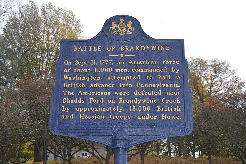
English: Historical marker, placed in 1952, at the entrance to the Brandywine Battlefield, located along U.S. Route 1 in Chadds Ford Township, Delaware County, Pennsylvania, United States. |
|||||
| Date | Taken on 20 October 2014 | |||||
| Source | Own work | |||||
| Author | Nyttend | |||||
| Permission (Reusing this file) |
Marker and photo respectively:
|

File history
Click on a date/time to view the file as it appeared at that time.
| Date/Time | Thumbnail | Dimensions | User | Comment | |
|---|---|---|---|---|---|
| current | 23:57, 10 November 2014 | | 6,016 × 4,000 (6.57 MB) | Nyttend | {{Location|39|52|27|N|75|34|40|W}} {{Information |Description={{en|Historical marker, placed in 1952, at the entrance to the {{w|Brandywine Battlefield}}, located along {{w|U.S. Route 1}} in {{w|Chadds Ford Township, Delaware County, Pennsylvania|Chadd... |
File usage
The following page uses this file:
You must be logged in to post a comment.