


Size of this preview: 683 × 600 pixels. Other resolutions: 273 × 240 pixels | 547 × 480 pixels | 998 × 876 pixels.
Original file (998 × 876 pixels, file size: 102 KB, MIME type: image/png)
Summary
| Description |
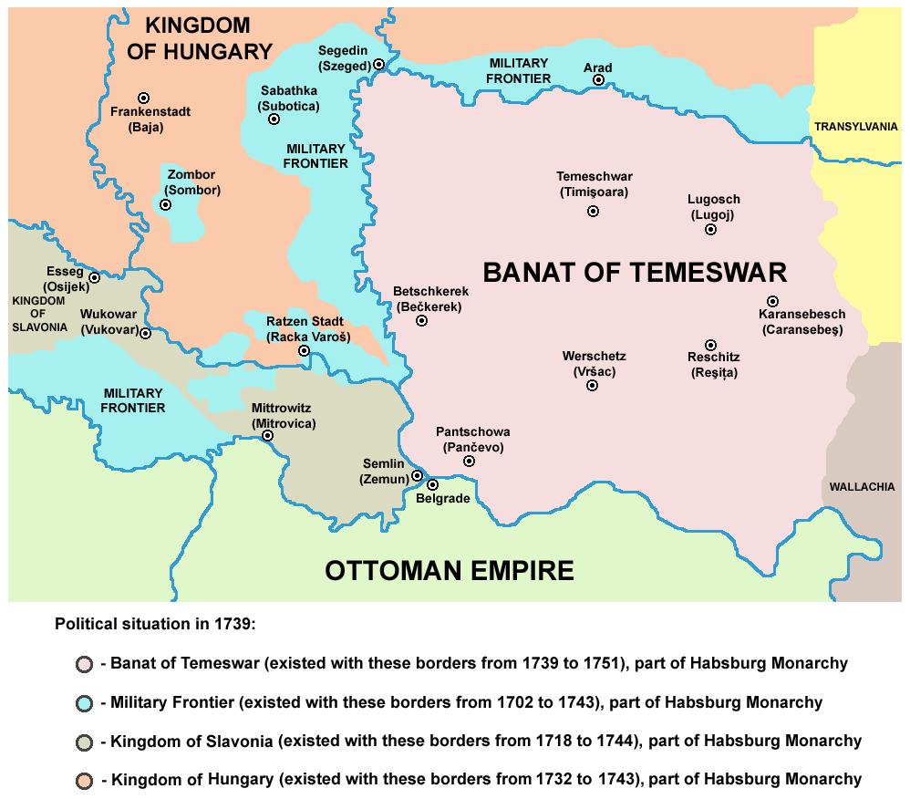
English: Map of the Banat of Temeswar and Military Frontier in 1739.
Српски / srpski: Мапа Тамишког Баната и војне границе 1739. године. |
| Date | 28 December 2006 (original upload date) |
| Source | Own work |
| Author | PANONIAN |
References
- The Times History of Europe, Times Books, 2002.
- Denis Šehić - Demir Šehić, Istorijski atlas Sveta, Beograd, 2007.
- Milan Tutorov, Banatska rapsodija - istorika Zrenjanina i Banata, Novi Sad, 2001.
- Peter Rokai - Zoltan Đere - Tibor Pal - Aleksandar Kasaš, Istorija Mađara, Beograd, 2002.
- Dr Dušan J. Popović, Srbi u Vojvodini, knjiga 2, Novi Sad, 1990.
- Dr Milenko Palić, Srbi u Mađarskoj - Ugarskoj do 1918, Novi Sad, 1995.
- J. H. Šviker, Politička istorija Srba u Ugarskoj, Novi Sad - Beograd, 1998.
- Fridrih Vilhelm fon Taube, Istorijski i geografski opis Kraljevine Slavonije i Vojvodstva Srema, Novi Sad, 1998.
- Miodrag Milin, Vekovima zajedno (Iz istorije srpsko-rumunskih odnosa), Temišvar, 1995.
- Suzana Milovanović, Potiska i pomoriška vojna granica (1702-1751), Novi Sad, 2003.
- Dimitrije Boarov, Politička istorija Vojvodine, Novi Sad, 2001.
- Drago Njegovan, Prisajedinjenje Vojvodine Srbiji, Novi Sad, 2004.
Source and licence

|
This map has been uploaded by Electionworld from en.wikipedia.org to enable the |
self made map by user:PANONIAN
Licensing
| I, the copyright holder of this work, release this work into the public domain. This applies worldwide. In some countries this may not be legally possible; if so: I grant anyone the right to use this work for any purpose, without any conditions, unless such conditions are required by law. |
File history
Click on a date/time to view the file as it appeared at that time.
| Date/Time | Thumbnail | Dimensions | User | Comment | |
|---|---|---|---|---|---|
| current | 22:37, 23 June 2014 | | 998 × 876 (102 KB) | WikiEditor2004 | aesthetics |
| 09:28, 22 June 2014 |  | 998 × 876 (102 KB) | WikiEditor2004 | aesthetics | |
| 10:33, 14 February 2013 |  | 997 × 876 (104 KB) | WikiEditor2004 | aesthetics | |
| 17:17, 30 September 2011 |  | 998 × 876 (104 KB) | WikiEditor2004 | correction | |
| 15:35, 29 September 2011 |  | 998 × 876 (105 KB) | WikiEditor2004 | corrections | |
| 19:27, 21 December 2009 |  | 998 × 876 (103 KB) | WikiEditor2004 | corrected mistake | |
| 14:26, 31 March 2009 |  | 998 × 876 (103 KB) | WikiEditor2004 | ||
| 11:57, 20 March 2009 |  | 998 × 876 (103 KB) | WikiEditor2004 | ||
| 02:05, 20 March 2009 |  | 998 × 841 (95 KB) | WikiEditor2004 | ||
| 23:11, 19 March 2009 |  | 998 × 841 (94 KB) | WikiEditor2004 |
File usage
The following 7 pages use this file:
Global file usage
The following other wikis use this file:
- Usage on als.wikipedia.org
- Usage on ar.wikipedia.org
- Usage on az.wikipedia.org
- Usage on bg.wikipedia.org
- Usage on bs.wikipedia.org
- Usage on ca.wikipedia.org
- Usage on da.wikipedia.org
- Usage on de.wikipedia.org
- Usage on el.wikipedia.org
- Usage on es.wikipedia.org
- Usage on et.wikipedia.org
- Usage on fa.wikipedia.org
- Usage on fr.wikipedia.org
- Usage on gl.wikipedia.org
- Usage on he.wikipedia.org
- Usage on it.wikipedia.org
- Usage on ja.wikipedia.org
- Usage on ko.wikipedia.org
- Usage on pl.wikipedia.org
- Usage on pt.wikipedia.org
- Usage on ro.wikipedia.org
- Usage on sh.wikipedia.org
- Usage on sl.wikipedia.org
- Usage on sr.wikipedia.org
- Usage on tr.wikipedia.org
- Usage on zh.wikipedia.org
You must be logged in to post a comment.