


Size of this preview: 423 × 599 pixels. Other resolutions: 169 × 240 pixels | 339 × 480 pixels | 542 × 768 pixels | 1,026 × 1,454 pixels.
Original file (1,026 × 1,454 pixels, file size: 571 KB, MIME type: image/jpeg)
Summary
A cleaned up version is available image:Balkan Wars Boundaries cleanup.jpg:
- Español: Límites de los Balcanes tras la Primera y Segunda guerra balcánica (1912-1913)
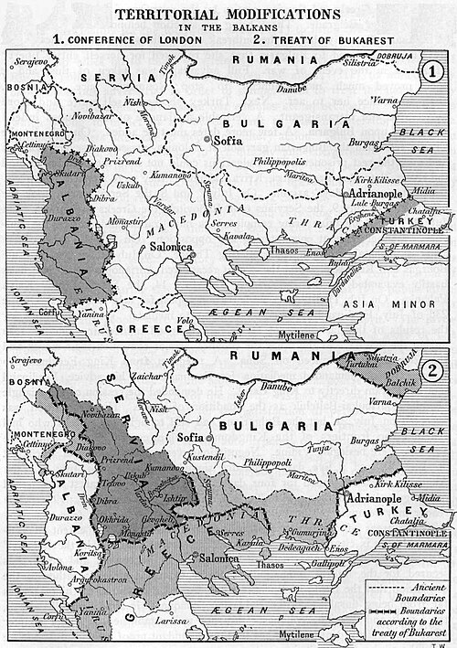
- English: Boundaries on the Balkans after the First and the Second Balkan War, 1912-1913.
- Svenska: Gränser på Balkan efter det första och andra balkankriget, 1912-1913.
Map from "Report of the International Commission To Inquire into the Causes and Conduct of the Balkan Wars", 1914.
Image history at en: (del) (cur) 15:12, 6 January 2005 . . JayO (287787 bytes) (Balkan Wars Boundaries)
Map printed and published in 1914
Licensing
This media file is in the public domain in the United States. This applies to U.S. works where the copyright has expired, often because its first publication occurred prior to January 1, 1930, and if not then due to lack of notice or renewal. See this page for further explanation.
|
 | |
 |
derivative works
Derivative works of this file:
File history
Click on a date/time to view the file as it appeared at that time.
| Date/Time | Thumbnail | Dimensions | User | Comment | |
|---|---|---|---|---|---|
| current | 16:04, 22 September 2010 | | 1,026 × 1,454 (571 KB) | DIREKTOR | Repairs |
| 00:22, 19 September 2005 |  | 1,044 × 1,471 (281 KB) | Thuresson | Boundaries on the Balkans after the First and the Second Balkan War, 1912-1913. Map from "''Report of the International Commission To Inquire into the Causes and Conduct of the Balkan Wars''", 1914. Image history at en: (del) (cur) 15:12, 6 January 200 |
File usage
The following 21 pages use this file:
- Albanian–Yugoslav border war (1921)
- Balkan Wars
- Bulgaria during World War I
- Destruction of the Thracian Bulgarians in 1913
- History of Bulgaria (1878–1946)
- History of Kosovo
- History of modern Macedonia (Greece)
- Hoti (tribe)
- Macedonia (region)
- May 1913
- Treaty of Bucharest (1913)
- Treaty of Constantinople (1913)
- Treaty of London (1913)
- Tsardom of Bulgaria (1908–1946)
- Talk:Balkan Wars/Archive 1
- User:Falcaorib/Balkans
- User:Falcaorib/Balkans maps
- User:Falcaorib/Bulgaria and North Macedonia
- User:Falcaorib/Serbia, Yugoslavia and Albania
- User:GerardM/Battles including the Ottoman Empire
- User:The Tom/Kosovo
Global file usage
The following other wikis use this file:
- Usage on af.wikipedia.org
- Usage on ar.wikipedia.org
- Usage on ast.wikipedia.org
- Usage on azb.wikipedia.org
- Usage on az.wikipedia.org
- Usage on ba.wikipedia.org
- Usage on be-tarask.wikipedia.org
- Usage on be.wikipedia.org
- Usage on bg.wikipedia.org
- Usage on bg.wikisource.org
- Usage on bn.wikipedia.org
- Usage on bs.wikipedia.org
- Usage on ca.wikipedia.org
- Usage on cs.wikipedia.org
View more global usage of this file.
You must be logged in to post a comment.