


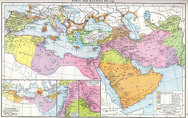
Size of this preview: 800 × 506 pixels. Other resolutions: 320 × 202 pixels | 640 × 404 pixels | 1,024 × 647 pixels | 1,280 × 809 pixels | 2,560 × 1,618 pixels | 4,496 × 2,841 pixels.
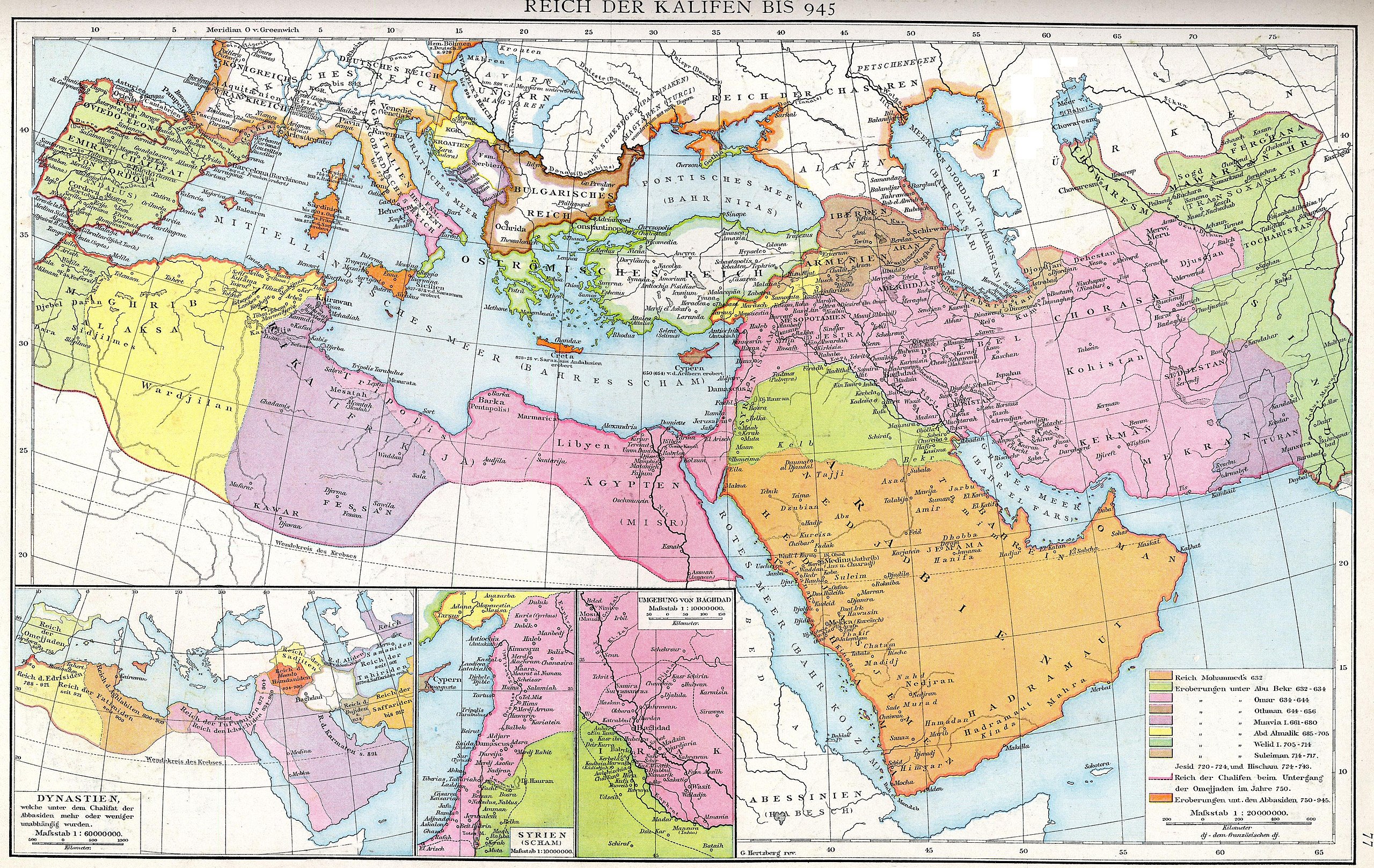
Original file (4,496 × 2,841 pixels, file size: 3.36 MB, MIME type: image/jpeg)
Summary
| Description |
Deutsch: Das Reich der Kalifen bis 945. Karte aus dem Historischen Handatlas von Gustav Droysen, 1886
English: The empire of the Caliphs to 945. Map of the Historical Atlas of Gustav Droysen, 1886 |
| Date | |
| Source | Gustav Droysens Allgemeiner historischer Handatlas in 96 Karten mit erläuterndem Text Bielefeld [u.a.]: Velhagen & Klasing 1886, S. 77. |
| Author | Johann Gustav Droysen (6 July 1808 – 19 June 1884) |
| Other versions |
Derivative works of this file: |
.jpg)
Licensing
|
This work is in the public domain in its country of origin and other countries and areas where the copyright term is the author's life plus 100 years or fewer. This work is in the public domain in the United States because it was published (or registered with the U.S. Copyright Office) before January 1, 1930. | |
| This file has been identified as being free of known restrictions under copyright law, including all related and neighboring rights. | |
File history
Click on a date/time to view the file as it appeared at that time.
| Date/Time | Thumbnail | Dimensions | User | Comment | |
|---|---|---|---|---|---|
| current | 13:23, 10 August 2012 | | 4,496 × 2,841 (3.36 MB) | Cplakidas | larger & better quality |
| 00:51, 24 February 2007 |  | 2,187 × 1,389 (754 KB) | Nikephoros | {{Information |Description=Karte des Kalifates vom Tode Mohammeds bis 945 |Source=Professor G. Droysens Allgemeiner Historischer Handatlas |Date=1886 |Author=G. Droysen |Permission=not necessary |other_versions= }} |
File usage
The following 12 pages use this file:
- Abbasid invasion of Asia Minor (806)
- Al-Mada'in
- Al-Mu'tasim
- Fourth Fitna
- Mu'awiya I
- User:Al Ameer son/Abd al-Malik
- User:Al Ameer son/Al-Walid I
- User:Al Ameer son/Sulayman
- User:Al Ameer son/Umayyad Caliphate
- User:Falcaorib/Iran
- User:Falcaorib/Medieval Empires (800-1000 AD)
- Wikipedia:Graphics Lab/Map workshop/Archive/Apr 2023
Global file usage
The following other wikis use this file:
- Usage on az.wikipedia.org
- Usage on ca.wikipedia.org
- Usage on de.wikipedia.org
- Usage on de.wikiversity.org
- Usage on el.wikipedia.org
- Usage on eo.wikipedia.org
- Usage on es.wikipedia.org
- Usage on fa.wikibooks.org
- Usage on fr.wikipedia.org
- Usage on id.wikipedia.org
- Usage on it.wikipedia.org
- Usage on ja.wikipedia.org
- Usage on ka.wikipedia.org
- Usage on sl.wikipedia.org
- Usage on sq.wikipedia.org
- Usage on sr.wikipedia.org
- Usage on tr.wikipedia.org
- Usage on ur.wikipedia.org
- Usage on uz.wikipedia.org
- Usage on zh.wikipedia.org
You must be logged in to post a comment.