


Size of this preview: 380 × 599 pixels. Other resolutions: 152 × 240 pixels | 406 × 640 pixels.
Original file (406 × 640 pixels, file size: 169 KB, MIME type: image/jpeg)
Summary
| Description |
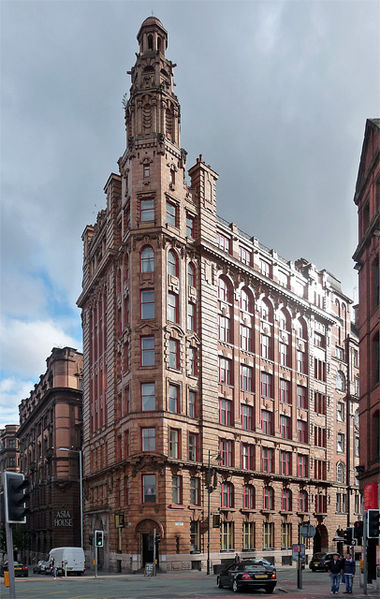
English: 67 Whitworth Street, known as Lancaster House, seen from the north. Formerly a warehouse, now grade II* listed |
| Date | |
| Source | https://www.geograph.org.uk/photo/2756018 |
| Author | Stephen Richards |
| Attribution (required by the license) | Stephen Richards / 67 Whitworth Street, Manchester / |
| Camera location | | View this and other nearby images on: OpenStreetMap |
|---|
Licensing

|
This image was taken from the Geograph project collection. See this photograph's page on the Geograph website for the photographer's contact details. The copyright on this image is owned by Stephen Richards and is licensed for reuse under the Creative Commons Attribution-ShareAlike 2.0 license.
|
This file is licensed under the Creative Commons Attribution-Share Alike 2.0 Generic license.
Attribution: Stephen Richards
- You are free:
- to share – to copy, distribute and transmit the work
- to remix – to adapt the work
- Under the following conditions:
- attribution – You must give appropriate credit, provide a link to the license, and indicate if changes were made. You may do so in any reasonable manner, but not in any way that suggests the licensor endorses you or your use.
- share alike – If you remix, transform, or build upon the material, you must distribute your contributions under the same or compatible license as the original.

|
This image has been assessed under the valued image criteria and is considered the most valued image on Commons within the scope: Lancaster House, Manchester north view. You can see its nomination here. |
File history
Click on a date/time to view the file as it appeared at that time.
| Date/Time | Thumbnail | Dimensions | User | Comment | |
|---|---|---|---|---|---|
| current | 03:18, 25 September 2012 | | 406 × 640 (169 KB) | Stevo1000 | User created page with UploadWizard |
File usage
The following 9 pages use this file:
Global file usage
The following other wikis use this file:
- Usage on ar.wikipedia.org
- Usage on cy.wikipedia.org
- Usage on dag.wikipedia.org
- Usage on es.wikipedia.org
- Usage on et.wikipedia.org
- Usage on incubator.wikimedia.org
- Usage on pt.wikipedia.org
- Usage on ru.wikipedia.org
- Usage on sl.wikipedia.org
- Usage on th.wikipedia.org
- Usage on uk.wikipedia.org
- Usage on vi.wikipedia.org
- Usage on www.wikidata.org
- Usage on zh.wikipedia.org
You must be logged in to post a comment.