


Original file (4,700 × 3,323 pixels, file size: 4 MB, MIME type: image/png)
Summary
| Description |
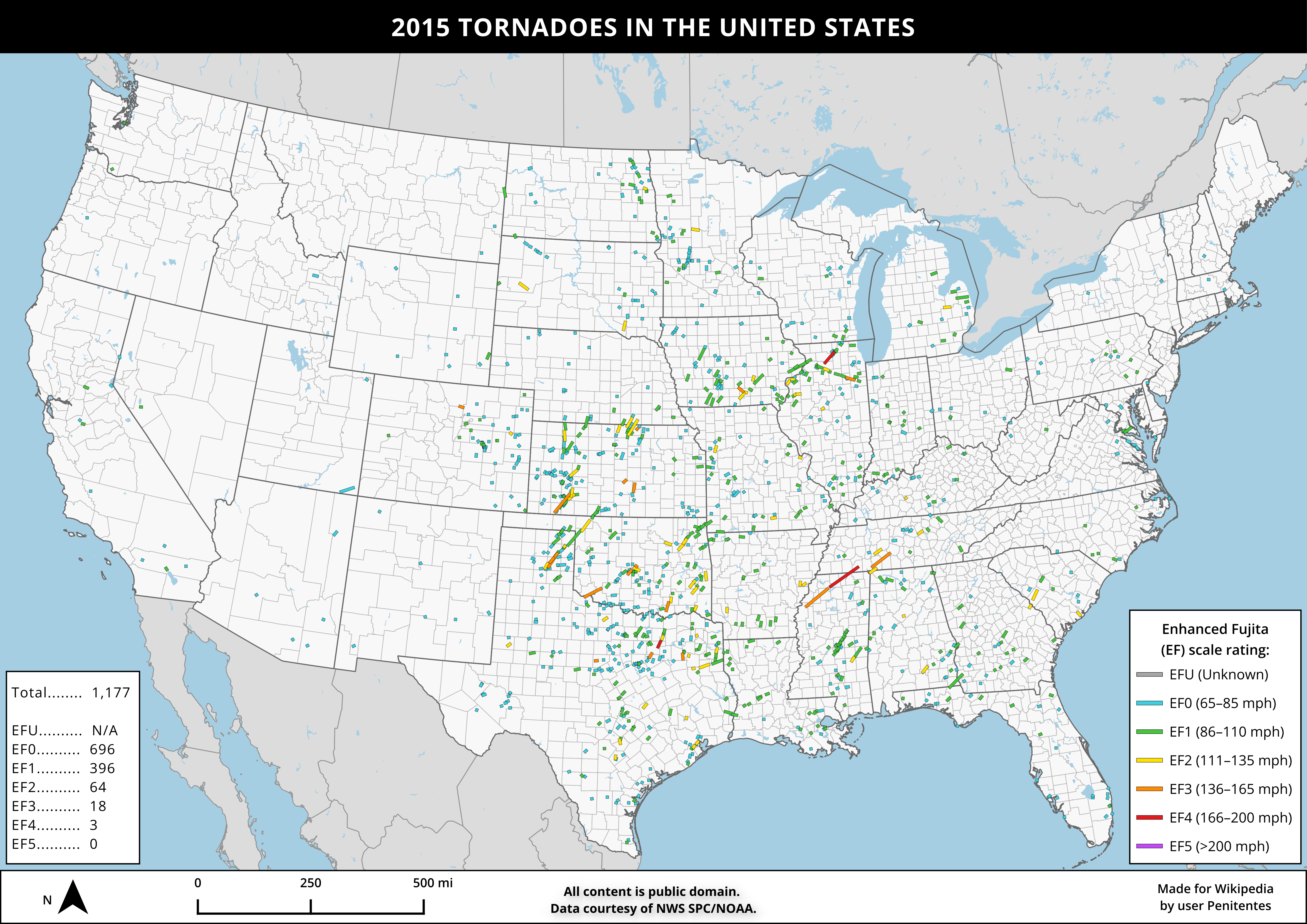
English: This image shows the paths of the 1,100+ tornadoes that occurred in the contiguous United States in 2015, colored by their rating on the Enhanced Fujita (EF) scale. This image was made in QGIS using data from Natural Earth and NWS SPC/NOAA. |
| Date | |
| Source | Own work |
| Author | Penitentes |
Licensing
Data
Tornado paths and ratings
Tornado paths and ratings were generated in QGIS using SVRGIS data provided by the National Weather Service Storm Prediction Center.
| This file is in the public domain in the United States because it was solely created by the National Weather Service (NWS), including its name from 1870–1970, the United States Weather Bureau (USWB).
This includes the sub-branches of the National Weather Service:
As a file created by an employee of the NWS (formerly USWB) in the course of their official duties, whether hosted
this work is in the public domain in the United States because it is a work prepared by an officer or employee of the United States Government as part of that person’s official duties under the terms of Title 17, Chapter 1, Section 105 of the US Code. |
||
 |
Warnings: (Click here to view)
|
Landmasses and oceans
Geographic features (including landmasses, oceans, and other bodies of water) were generated in QGIS using data provided by Natural Earth.
This file is in the public domain because all Natural Earth published vector and raster data is released into the public domain (see their Terms of Use).
|
Country, state, and province boundaries
Country, state, and province boundaries were generated in QGIS using data provided by Natural Earth.
This file is in the public domain because all Natural Earth published vector and raster data is released into the public domain (see their Terms of Use).
|
United States county boundaries
United States county boundaries were generated in QGIS using TIGER/MAF data provided by the United States Census Bureau.
This image or file is a work of a United States Census Bureau employee, taken or made as part of that person's official duties. As a work of the U.S. federal government, the image is in the public domain.
|
 |
Final map
- You are free:
- to share – to copy, distribute and transmit the work
- to remix – to adapt the work
- Under the following conditions:
- attribution – You must give appropriate credit, provide a link to the license, and indicate if changes were made. You may do so in any reasonable manner, but not in any way that suggests the licensor endorses you or your use.
- share alike – If you remix, transform, or build upon the material, you must distribute your contributions under the same or compatible license as the original.
File history
Click on a date/time to view the file as it appeared at that time.
| Date/Time | Thumbnail | Dimensions | User | Comment | |
|---|---|---|---|---|---|
| current | 17:49, 15 June 2024 | | 4,700 × 3,323 (4 MB) | Penitentes | improved legend symbology + tornado visibility by magnitude |
| 02:30, 12 June 2024 |  | 4,700 × 3,323 (4 MB) | Penitentes | Uploaded own work with UploadWizard |
File usage
The following 2 pages use this file:
You must be logged in to post a comment.