


Berné (French pronunciation: [bɛʁne]; Berne in Breton) is a commune in the Morbihan department in Brittany in northwestern France.
Population
Inhabitants of Berné are called Bernéens.
|
| ||||||||||||||||||||||||||||||||||||||||||||||||||||||||||||||||||||||||||||||||||||||||||||||||||||||||||||||||||
| Source: EHESS[3] and INSEE (1968-2020)[4] | |||||||||||||||||||||||||||||||||||||||||||||||||||||||||||||||||||||||||||||||||||||||||||||||||||||||||||||||||||
Geography
Berné is located in the western part of Morbihan, 28 km (17 mi) north of Lorient, 32 km (20 mi) west of Pontivy and 40 km (25 mi) northwest of Vannes. The commune is wooded and hilly. The forest of Pontcallec cover a large part of the commune's area. The river Scorff forms the commune's eastern and southern borders.
Map

History
Second world war
Seventeen French resistance fighters were shot dead by the German soldiers in the Landordu wood. Some victims were buried alive. Their bodies were exhumed on July 6, 1944.
List of places
|
|
|
|
|
Gallery
-
 Pontcallec castle
 -
 St Anne des Bois's chapel
 -
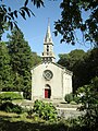
 St Albaud's chapel
 -
 St Albaud's chapel
 -
 Sacré Coeur


See also
References
- ^ "Maires du Morbihan" (PDF). Préfecture du Morbihan. 7 July 2020.
- ^ "Populations de référence 2022" (in French). The National Institute of Statistics and Economic Studies. 19 December 2024.
- ^ Des villages de Cassini aux communes d'aujourd'hui: Commune data sheet Berné, EHESS (in French).
- ^ Population en historique depuis 1968, INSEE
External links
- Base Mérimée: Search for heritage in the commune, Ministère français de la Culture. (in French)
- Mayors of Morbihan Association (in French)
| Authority control databases: National |
|---|
You must be logged in to post a comment.