


Zhanang County or Dranang (Tibetan: གྲ་ནང་རྫོང, Chinese: 扎囊县) is a county of Shannan (Lhokha) in the Tibet Autonomous Region, China. The capital town of county is Dratang town, with a monastery named Dratang.[2]
Geography
Dranang County is home to Samye Monastery, the first Buddhist monastery in Tibet, and many other monasteries, including Mindrolling Monastery.
Dranang County is separated into northern and southern parts by the Yarlung Tsangpo River. In 2015, a bridge near Dratang Town was finished, connecting the northern and southern parts of the county.[3]
History
Historically a strategic hub since the Tibetan Empire (7th–9th centuries CE), it served as a cultural and administrative center under the patronage of the Nyingma school of Tibetan Buddhism. The county's name, Dranang, meaning "thorn grove" in Tibetan,[4] reflects its early settlement patterns in the arid valleys.[5]
Zhanang was established as a county in April 1960 following Tibet's democratic reforms, initially under the Lhoka Special Administrative Region. Its boundaries were formalized in 1987, encompassing 5 townships and 3 towns by 2015.[6] A major restructuring in 2021 merged rural townships into urban units, reducing divisions to 3 towns and 2 townships. The county's 2,173 km² area blends agricultural plains with rugged mountains, sustaining barley farming and traditional crafts like Tibetan incense production.[7]
Administrative divisions
Dranang County contains 2 towns and 3 townships.
| Name | Chinese | Hanyu Pinyin | Tibetan | Wylie |
|---|---|---|---|---|
| Towns | ||||
| Dratang Town | 扎塘镇 | Zhātáng zhèn | གྲ་ཐང་གྲོང་རྡལ། | grang thang grong rdal |
| Samye Town | 桑耶镇 | Sāngyē zhèn | བསམ་ཡས་གྲོང་རྡལ། | bsam yas grong rdal |
| Townships | ||||
| Drachi Township | 扎其乡 | Zhāqí xiāng | གྲ་ཕྱི་ཤང་། | gra phyi shang |
| Ngadra Township | 阿扎乡 | Āzhā xiāng | ལྔ་གྲ་ཤང་། | lnga gra shang |
| Gyiru Township | 吉汝乡 | Jírǔ xiāng | དཀྱིལ་རུ་ཤང་། | dkyil ru shang |
Climate
| Climate data for Dranang (1981−2010) | |||||||||||||
|---|---|---|---|---|---|---|---|---|---|---|---|---|---|
| Month | Jan | Feb | Mar | Apr | May | Jun | Jul | Aug | Sep | Oct | Nov | Dec | Year |
| Mean daily maximum °C (°F) | 8.7 (47.7) |
10.7 (51.3) |
14.2 (57.6) |
17.3 (63.1) |
20.9 (69.6) |
24.1 (75.4) |
23.2 (73.8) |
22.0 (71.6) |
20.6 (69.1) |
17.9 (64.2) |
13.1 (55.6) |
9.2 (48.6) |
16.8 (62.3) |
| Daily mean °C (°F) | −0.6 (30.9) |
2.4 (36.3) |
6.4 (43.5) |
9.5 (49.1) |
13.3 (55.9) |
16.7 (62.1) |
16.4 (61.5) |
15.7 (60.3) |
13.9 (57.0) |
9.6 (49.3) |
3.2 (37.8) |
−0.7 (30.7) |
8.8 (47.9) |
| Mean daily minimum °C (°F) | −8.2 (17.2) |
−5.4 (22.3) |
−1.4 (29.5) |
2.3 (36.1) |
6.3 (43.3) |
10.4 (50.7) |
11.3 (52.3) |
11.0 (51.8) |
9.0 (48.2) |
3.4 (38.1) |
−4.2 (24.4) |
−7.9 (17.8) |
2.2 (36.0) |
| Average precipitation mm (inches) | 0.4 (0.02) |
0.3 (0.01) |
1.6 (0.06) |
6.9 (0.27) |
20.3 (0.80) |
49.6 (1.95) |
119.4 (4.70) |
122.5 (4.82) |
66.4 (2.61) |
8.8 (0.35) |
0.4 (0.02) |
0.5 (0.02) |
397.1 (15.63) |
| Average relative humidity (%) | 35 | 29 | 30 | 38 | 44 | 51 | 63 | 67 | 64 | 51 | 43 | 43 | 47 |
| Source: Weather China[8] | |||||||||||||
Gallery
-
 Samye monastery
 -
 Black stupa of Samye
 -
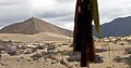 Near Samye monastery
 -
 Yarlung Tsangpo
 -
 Yarlung Tsangpo
 -
 Yarlung Tsangpo


References
- ^ "山南市第七次全国人口普查主要数据公报" (in Chinese). Statistics Bureau of Lhoka. 2021-06-24.
- ^ "Dratang". The Treasury of Lives. Retrieved 2018-09-15.
- ^ 扎囊县民主改革时期档案整理与研究. 西藏历史与现状综合研究项目 (in Chinese). 社会科学文献出版社. 2014. p. 3. ISBN 978-7-5097-5116-9. Retrieved 2025-03-04.
- ^ 佛界: 神秘的西藏寺院 (in Chinese). 青海人民出版社. 1997. p. 69. ISBN 978-7-225-01362-6. Retrieved 2025-03-04.
- ^ 西藏农牧史. 西藏历史与现状综合研究项目 (in Chinese). 社会科学文献出版社. 2014. p. 43. ISBN 978-7-5097-5972-1. Retrieved 2025-03-04.
- ^ 中国扶贫开发政策演变(2001-2015年). 中国减贫研究书系. 专题研究 (in Chinese). 社会科学文献出版社. 2016. p. 68. ISBN 978-7-5097-9733-4. Retrieved 2025-03-04.
- ^ 西藏重要高原特色农产品基地建设与扶持政策研究 (in Chinese). 社会科学文献出版社. 2013. p. 158. ISBN 978-7-5097-5201-2. Retrieved 2025-03-04.
- ^ 扎囊- 气象数据 -中国气象数据网 (in Chinese (China)). Weather China. Archived from the original on 2021-02-19. Retrieved 2012-06-17.

| International | |
|---|---|
| National | |
You must be logged in to post a comment.