


Saratoga, Mississippi
Saratoga, Mississippi | |
|---|---|
 Saratoga, Mississippi  Saratoga, Mississippi | |
| Coordinates: 31°47′49″N 89°40′39″W / 31.79694°N 89.67750°W | |
| Country | United States |
| State | Mississippi |
| County | Simpson |
| Elevation | 341 ft (104 m) |
| Time zone | UTC-6 (Central (CST)) |
| • Summer (DST) | UTC-5 (CDT) |
| Area codes | 601 & 769 |
| GNIS feature ID | 692209[1] |
Saratoga is an unincorporated community in Simpson County, in the U.S. state of Mississippi.[1]
History
Saratoga is located on the Canadian National Railway and once had a railroad depot.[2]
In 1906, Saratoga was home to two sawmills, a planing mill, a general store and a bottleworks.[3]
A post office called Saratoga was established in 1900, and remained in operation until 1920.[4] The community's name is a transfer from Saratoga, in Upstate New York.[5] A variant name is "Togey".[1]
References
- ^ a b c U.S. Geological Survey Geographic Names Information System: Saratoga
- ^ Howe, Tony. "Saratoga, Mississippi". Mississippi Rails. Retrieved October 10, 2025.
- ^ Rowland, Dunbar (1907). Mississippi: Comprising Sketches of Counties, Towns, Events, Institutions, and Persons, Arranged in Cyclopedic Form (PDF). Vol. 2. Southern Historical Publishing Association. p. 593.
- ^ "Post Offices". Jim Forte Postal History. Retrieved August 20, 2019.
- ^ Baca, Keith A. (2007). Native American Place Names in Mississippi. University Press of Mississippi. p. 90. ISBN 978-1-60473-483-6.
Municipalities and communities of Simpson County, Mississippi, United States | ||
|---|---|---|
| Cities | 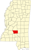 | |
| Town | ||
| Village | ||
| Unincorporated communities | ||
| Ghost town | ||