


Size of this preview: 456 × 599 pixels. Other resolutions: 183 × 240 pixels | 540 × 709 pixels.
Original file (540 × 709 pixels, file size: 125 KB, MIME type: image/jpeg)
Summary
| Description |
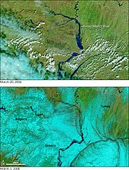
English: Satellite image of floods along the Evros (Meric) river in 2006.
Ελληνικά: Δορυφορικές εικόνες των πλημμύρων στο ποταμό Έβρο το 2006. |
| Date | |
| Source | http://earthobservatory.nasa.gov/IOTD/view.php?id=6397 |
| Author | NASA images courtesy the MODIS Rapid Response Team at NASA GSFC. |
Licensing
| This file is in the public domain in the United States because it was solely created by NASA. NASA copyright policy states that "NASA material is not protected by copyright unless noted". (See Template:PD-USGov, NASA copyright policy page or JPL Image Use Policy.) | ||
 |
Warnings:
|
File history
Click on a date/time to view the file as it appeared at that time.
| Date/Time | Thumbnail | Dimensions | User | Comment | |
|---|---|---|---|---|---|
| current | 23:32, 13 October 2010 | | 540 × 709 (125 KB) | Ggia | {{Information |Description={{en|1=Satellite image of floods along the Evros (Meric) river in 2006.}} {{el|1=Δορυφορικές εικόνες των πλημμύρων στο ποταμό Έβρο το 2006. }} |Source=http://earthobservatory.nasa.gov |
File usage
The following page uses this file:
Global file usage
The following other wikis use this file:
- Usage on da.wikipedia.org
- Usage on el.wikipedia.org
- Usage on hyw.wikipedia.org
- Usage on ja.wikipedia.org
- Usage on tr.wikipedia.org
You must be logged in to post a comment.