


No higher resolution available.
Tu-map.png (631 × 321 pixels, file size: 23 KB, MIME type: image/png)
From en.wikipedia
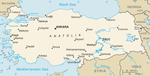
map of Turkey, converted directly from CIA World Factbook GIF
This image is in the public domain because it contains materials that originally came from the United States Central Intelligence Agency's World Factbook.
|
 |
derivative works
Derivative works of this file: Tu-map-ar.png
File history
Click on a date/time to view the file as it appeared at that time.
| Date/Time | Thumbnail | Dimensions | User | Comment | |
|---|---|---|---|---|---|
| current | 07:35, 19 February 2022 | | 631 × 321 (23 KB) | Lojwe | Cropped < 1 % horizontally, 1 % vertically using CropTool with precise mode. |
| 01:25, 13 September 2012 |  | 634 × 324 (41 KB) | Thricecube | Updated map | |
| 07:31, 27 September 2005 |  | 737 × 375 (192 KB) | Kgyt | From en.wikipedia map of Turkey, converted directly from CIA World Factbook GIF {{PD-USGov-CIA-WF}} | |
| 19:49, 6 January 2005 |  | 634 × 324 (19 KB) | Lukius~commonswiki | From en.wikipedia |
File usage
The following 6 pages use this file:
Global file usage
The following other wikis use this file:
- Usage on az.wikipedia.org
- Usage on be-tarask.wikipedia.org
- Usage on bh.wikipedia.org
- Usage on bn.wikipedia.org
- Usage on bxr.wikipedia.org
- Usage on ckb.wikipedia.org
- Usage on da.wikipedia.org
- Usage on dsb.wikipedia.org
- Usage on en.wikivoyage.org
- Usage on eo.wikipedia.org
- Usage on es.wikipedia.org
- Usage on gag.wikipedia.org
- Usage on gl.wikipedia.org
- Usage on hi.wikipedia.org
- Usage on hu.wikipedia.org
- Usage on id.wikipedia.org
- Usage on incubator.wikimedia.org
- Usage on io.wikipedia.org
- Usage on is.wikipedia.org
- Usage on it.wikipedia.org
- Usage on it.wikinews.org
- Usage on ja.wikipedia.org
- Usage on jv.wikipedia.org
- Usage on ko.wikipedia.org
- Usage on lfn.wikipedia.org
- Usage on mk.wikipedia.org
- Usage on mr.wikipedia.org
- Usage on ms.wikipedia.org
- Usage on nap.wikipedia.org
- Usage on nl.wikibooks.org
- Usage on nl.wiktionary.org
View more global usage of this file.
You must be logged in to post a comment.