


Size of this preview: 450 × 600 pixels. Other resolutions: 180 × 240 pixels | 480 × 640 pixels.
Original file (480 × 640 pixels, file size: 113 KB, MIME type: image/jpeg)
Summary
| Description |
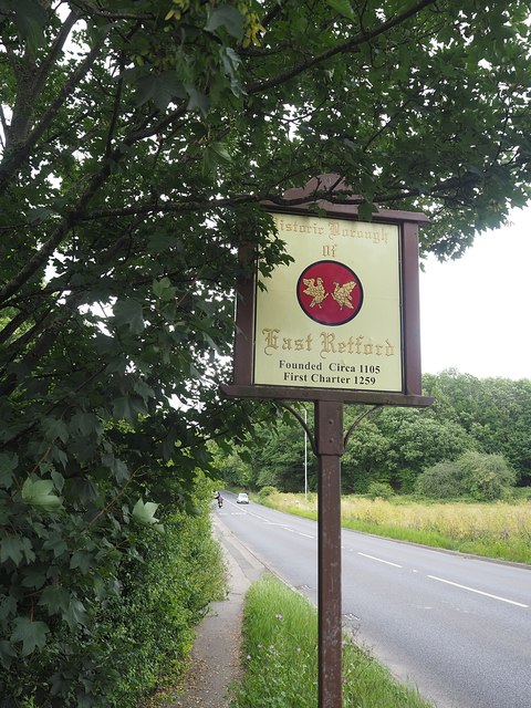
English: East Retford Borough boundary sign |
| Date | |
| Source | From geograph.org.uk |
| Author | Graham Hogg |
| Permission (Reusing this file) |
Creative Commons Attribution Share-alike license 2.0 |
| Attribution (required by the license) | Graham Hogg / East Retford Borough boundary sign / |
| Camera location | | View this and other nearby images on: OpenStreetMap |
|---|
_heading:67.00&language=en)
| Object location | | View this and other nearby images on: OpenStreetMap |
|---|
_heading:67.00&language=en)
Licensing

|
This image was taken from the Geograph project collection. See this photograph's page on the Geograph website for the photographer's contact details. The copyright on this image is owned by Graham Hogg and is licensed for reuse under the Creative Commons Attribution-ShareAlike 2.0 license.
|
This file is licensed under the Creative Commons Attribution-Share Alike 2.0 Generic license.
Attribution: Graham Hogg
- You are free:
- to share – to copy, distribute and transmit the work
- to remix – to adapt the work
- Under the following conditions:
- attribution – You must give appropriate credit, provide a link to the license, and indicate if changes were made. You may do so in any reasonable manner, but not in any way that suggests the licensor endorses you or your use.
- share alike – If you remix, transform, or build upon the material, you must distribute your contributions under the same or compatible license as the original.

|
This media file is uncategorized.
Please help improve this media file by adding it to one or more categories, so it may be associated with related media files (how?), and so that it can be more easily found.
Please notify the uploader with {{subst:Please link images|File:Retford boundary sign.jpg}} ~~~~ |
File history
Click on a date/time to view the file as it appeared at that time.
| Date/Time | Thumbnail | Dimensions | User | Comment | |
|---|---|---|---|---|---|
| current | 22:19, 4 April 2021 | | 480 × 640 (113 KB) | Bjh21 | Un-watermarked version from Geograph |
| 20:48, 21 February 2021 |  | 480 × 640 (114 KB) | SandrinaHatman | == {{int:filedesc}} == {{Information |Description={{en|1=East Retford Borough boundary sign}} |Source=From [https://www.geograph.org.uk/photo/6539625 geograph.org.uk] |Date=2020-07-13 |Author=[https://www.geograph.org.uk/profile/47667 Graham Hogg] |Permission=Creative Commons Attribution Share-alike license 2.0 |Other fields={{Credit line |Author=Graham Hogg |License=[https://creativecommons.org/licenses/by-sa/2.0/ CC BY-SA 2.0] |Other=''East Retford Borough boundary sign'' }} }} {{Locati... |
File usage
The following page uses this file:
You must be logged in to post a comment.