


No higher resolution available.
IE80Class.jpg (640 × 417 pixels, file size: 92 KB, MIME type: image/jpeg)
Summary
| Description |
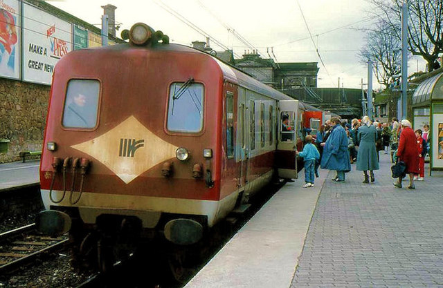
English: Work was underway on the up line between Dun Laoghaire and Bray. The current to the overhead lines had been switched off for the duration. A limited shuttle service, with chartered Northern Ireland Railways diesel railcars (normally used for the Bray-Greystones service), operated over the down line. |
| Date | |
| Source | From geograph.org.uk |
| Author | Aubrey Dale |
| Permission (Reusing this file) |
Creative Commons Attribution Share-alike license 2.0 |
| Camera location | | View this and other nearby images on: OpenStreetMap |
|---|
Licensing

|
This image was taken from the Geograph project collection. See this photograph's page on the Geograph website for the photographer's contact details. The copyright on this image is owned by Aubrey Dale and is licensed for reuse under the Creative Commons Attribution-ShareAlike 2.0 license.
|
This file is licensed under the Creative Commons Attribution-Share Alike 2.0 Generic license.
Attribution: Aubrey Dale
- You are free:
- to share – to copy, distribute and transmit the work
- to remix – to adapt the work
- Under the following conditions:
- attribution – You must give appropriate credit, provide a link to the license, and indicate if changes were made. You may do so in any reasonable manner, but not in any way that suggests the licensor endorses you or your use.
- share alike – If you remix, transform, or build upon the material, you must distribute your contributions under the same or compatible license as the original.
File history
Click on a date/time to view the file as it appeared at that time.
| Date/Time | Thumbnail | Dimensions | User | Comment | |
|---|---|---|---|---|---|
| current | 18:26, 21 March 2010 | | 640 × 417 (92 KB) | Grover Snodd | == {{int:filedesc}} == {{Information |Description={{en|1=Diesel railcars at Dun Laoghaire}} |Source=From [http://www.geograph.org.uk/photo/1628605 geograph.org.uk] |Date=1988-04-16 |Author=[http://www.geograph.org.uk/profile/5835 Aubrey Dale] |Permission= |
File usage
The following 4 pages use this file:
Global file usage
The following other wikis use this file:
- Usage on zh.wikipedia.org
You must be logged in to post a comment.