


Size of this preview: 405 × 599 pixels. Other resolutions: 162 × 240 pixels | 433 × 640 pixels.
Original file (433 × 640 pixels, file size: 115 KB, MIME type: image/jpeg)
This is a photo of listed building number 1365476. |
| Camera location | | View this and other nearby images on: OpenStreetMap |
|---|
| Object location | | View this and other nearby images on: OpenStreetMap |
|---|
_region:GB-ENG_&language=en)
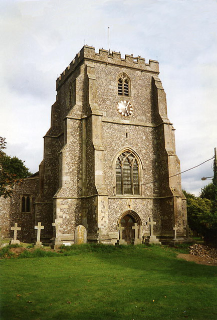
| Description | Church of the Holy Cross, Ramsbury, UK. "A rather solid, squat tower built with flint; inside the church are the remains of a Saxon cross. There was a bishopric here in the 10th century which was merged with the see of Sherborne in 1058, so the site the church stands on is probably an ancient and significant one" |
| Date | |
| Source | https://www.geograph.org.uk/photo/84902 |
| Author | Geograph user Martin Bodman |
| Permission (Reusing this file) |
Offered under Creative Commons Attribution-ShareAlike 2.0 |

|
This image was taken from the Geograph project collection. See this photograph's page on the Geograph website for the photographer's contact details. The copyright on this image is owned by Martin Bodman and is licensed for reuse under the Creative Commons Attribution-ShareAlike 2.0 license.
|
This file is licensed under the Creative Commons Attribution-Share Alike 2.0 Generic license.
Attribution: Martin Bodman
- You are free:
- to share – to copy, distribute and transmit the work
- to remix – to adapt the work
- Under the following conditions:
- attribution – You must give appropriate credit, provide a link to the license, and indicate if changes were made. You may do so in any reasonable manner, but not in any way that suggests the licensor endorses you or your use.
- share alike – If you remix, transform, or build upon the material, you must distribute your contributions under the same or compatible license as the original.
File history
Click on a date/time to view the file as it appeared at that time.
| Date/Time | Thumbnail | Dimensions | User | Comment | |
|---|---|---|---|---|---|
| current | 19:39, 7 October 2006 | | 433 × 640 (115 KB) | William Avery | {{Information |Description=Church of the Holy Cross, Ramsbury, UK. "A rather solid, squat tower built with with flint; inside the church are the remains of a Saxon cross. There was a bishopric here in the 10th century which was merged with |
File usage
The following 5 pages use this file:
Global file usage
The following other wikis use this file:
- Usage on azb.wikipedia.org
- Usage on ceb.wikipedia.org
- Usage on cy.wikipedia.org
- Usage on dag.wikipedia.org
- Usage on es.wikipedia.org
- Usage on eu.wikipedia.org
- Usage on fa.wikipedia.org
- Usage on fr.wikipedia.org
- Usage on lld.wikipedia.org
- Usage on pl.wikipedia.org
- Usage on ur.wikipedia.org
- Usage on vo.wikipedia.org
- Usage on www.wikidata.org
- Usage on zh-min-nan.wikipedia.org
You must be logged in to post a comment.