


Size of this PNG preview of this SVG file: 577 × 593 pixels. Other resolutions: 234 × 240 pixels | 467 × 480 pixels | 747 × 768 pixels | 996 × 1,024 pixels | 1,993 × 2,048 pixels.
Original file (SVG file, nominally 577 × 593 pixels, file size: 30 KB)
| U.S. presidential election maps (SVG) |
| See also: National Atlas maps (png) |
|
1788-1789 · 1792 · 1796 · 1800 · 1804 · 1808 · 1812 · 1816 · 1820 · 1824 · 1828 · 1832 · 1836 · 1840 · 1844 · 1848 · 1852 · 1856 · 1860 · 1864 · 1868 · 1872 · 1876 · 1880 · 1884 · 1888 · 1892 · 1896 · 1900 · 1904 · 1908 · 1912 · 1916 · 1920 · 1924 · 1928 · 1932 · 1936 · 1940 · 1944 · 1948 · 1952 · 1956 · 1960 · 1964 · 1968 · 1972 · 1976 · 1980 · 1984 · 1988 · 1992 · 1996 · 2000 · 2004 · 2008 · 2012 · 2016 · 2020 · 2024 |
Summary
| Description |
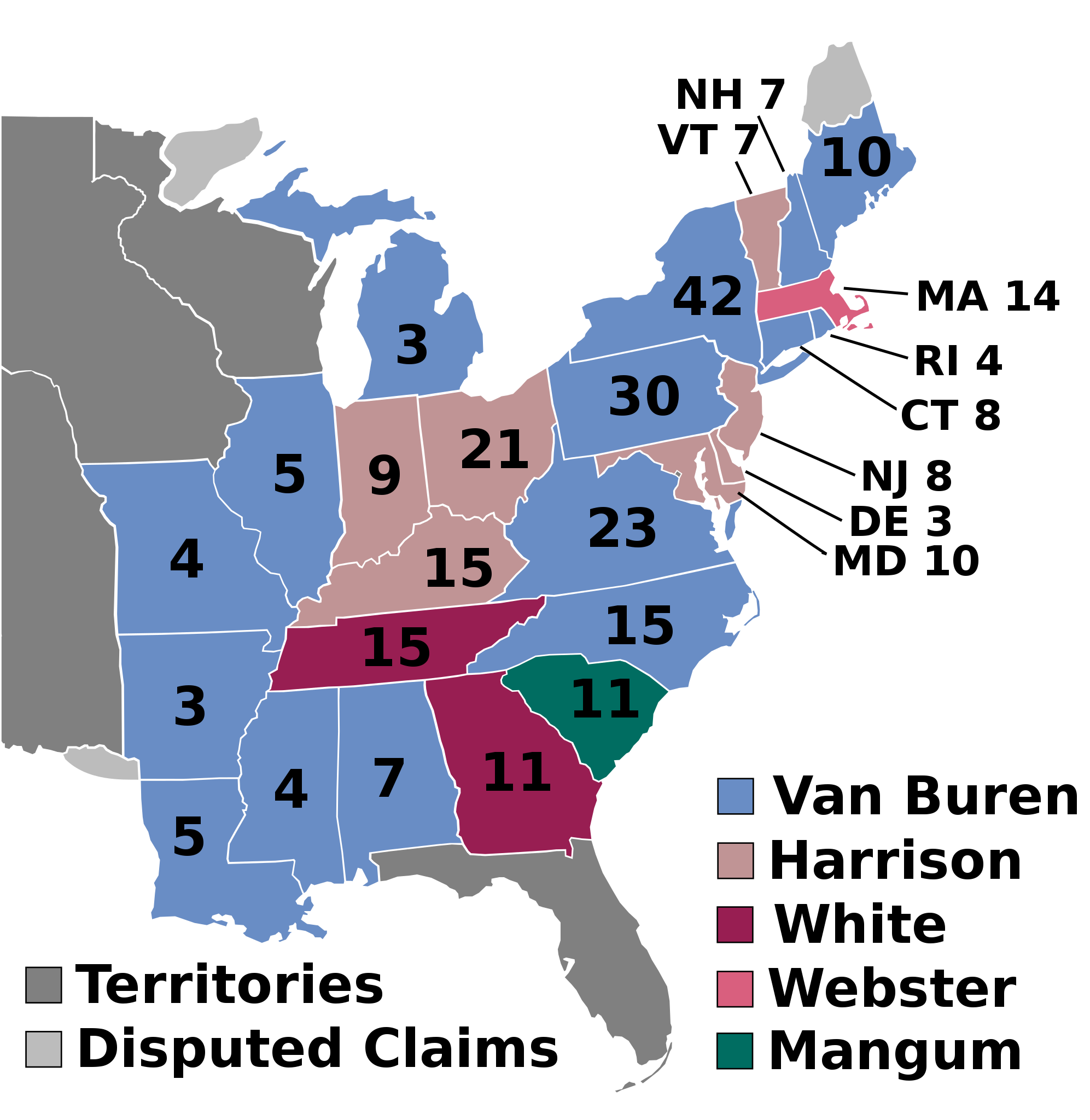
English: 1836 Electoral College |
| Date | Unknown date |
| Source | Own work |
| Author | AndyHogan14 |
| SVG development | W3C-validity not checked. |
Licensing
| I, the copyright holder of this work, release this work into the public domain. This applies worldwide. In some countries this may not be legally possible; if so: I grant anyone the right to use this work for any purpose, without any conditions, unless such conditions are required by law. |
File history
Click on a date/time to view the file as it appeared at that time.
| Date/Time | Thumbnail | Dimensions | User | Comment | |
|---|---|---|---|---|---|
| current | 03:17, 27 February 2025 | | 577 × 593 (30 KB) | Interesting 2752 | Revert from old version of the map to the newest version |
| 20:06, 26 February 2025 |  | 612 × 558 (81 KB) | Ecotto29200 | Reverted to version as of 03:08, 2 August 2016 (UTC) | |
| 10:49, 19 November 2024 |  | 577 × 593 (30 KB) | Arnapha | Clearer borders | |
| 16:43, 2 June 2024 |  | 577 × 593 (174 KB) | GatewayPolitics | Colors to reflect the county maps | |
| 22:36, 11 July 2018 |  | 577 × 593 (175 KB) | Wow | fix | |
| 10:00, 11 July 2018 |  | 577 × 593 (175 KB) | Wow | numbers | |
| 09:50, 11 July 2018 |  | 577 × 593 (175 KB) | Wow | disputed claim | |
| 21:36, 14 November 2016 |  | 612 × 558 (85 KB) | Wow | Territories | |
| 03:08, 2 August 2016 |  | 612 × 558 (81 KB) | Spartan7W | no need for entire west w/o states | |
| 20:34, 7 June 2016 |  | 1,034 × 572 (68 KB) | Rrostrom | replacement of existing file with spelling error fixed ("Magnum" --> "Mangum") {{PD-user|AndyHogan14}} |
File usage
The following 51 pages use this file:
- 1836 United States elections
- 1836 United States presidential election
- 1836 United States presidential election in Alabama
- 1836 United States presidential election in Arkansas
- 1836 United States presidential election in Connecticut
- 1836 United States presidential election in Delaware
- 1836 United States presidential election in Georgia
- 1836 United States presidential election in Illinois
- 1836 United States presidential election in Indiana
- 1836 United States presidential election in Kentucky
- 1836 United States presidential election in Louisiana
- 1836 United States presidential election in Maine
- 1836 United States presidential election in Maryland
- 1836 United States presidential election in Massachusetts
- 1836 United States presidential election in Michigan
- 1836 United States presidential election in Mississippi
- 1836 United States presidential election in Missouri
- 1836 United States presidential election in New Hampshire
- 1836 United States presidential election in New Jersey
- 1836 United States presidential election in New York
- 1836 United States presidential election in North Carolina
- 1836 United States presidential election in Ohio
- 1836 United States presidential election in Pennsylvania
- 1836 United States presidential election in Rhode Island
- 1836 United States presidential election in South Carolina
- 1836 United States presidential election in Tennessee
- 1836 United States presidential election in Vermont
- 1836 United States presidential election in Virginia
- 1836 in the United States
- Daniel Webster
- Electoral vote changes between United States presidential elections
- List of United States presidential election results by state
- Martin Van Buren
- Presidency of Andrew Jackson
- Presidency of Martin Van Buren
- United States presidential election
- User:1aWIKIAL1,/sandbox
- User:DukeOfDelTaco/U.S. Presidential Elections
- User:Falcaorib/United States presidential elections
- User:RapidsLurker15/United States presidential elections
- User:Ratsputin2.0/sandbox
- Wikipedia:Graphics Lab/Illustration workshop/Archive/Nov 2011
- Template:1836 United States presidential election imagemap
- Template:State results of the 1836 U.S. presidential election
- Draft:2040 United States presidential election
- Draft:2044 United States presidential election
- Draft:2048 United States presidential election
- Draft:2052 United States presidential election
- Draft:2056 United States presidential election
- Draft:2060 United States presidential election
- Draft:2064 United States presidential election
Global file usage
The following other wikis use this file:
- Usage on da.wikipedia.org
- Usage on de.wikipedia.org
- Usage on el.wikipedia.org
- Usage on es.wikipedia.org
- Usage on fa.wikipedia.org
- Usage on fi.wikipedia.org
- Usage on fr.wikipedia.org
- Usage on he.wikipedia.org
- Usage on it.wikipedia.org
- Usage on ja.wikipedia.org
- Usage on ko.wikipedia.org
- Usage on pl.wikipedia.org
- Usage on pt.wikipedia.org
- Usage on ru.wikipedia.org
- Usage on sr.wikipedia.org
- Usage on sv.wikipedia.org
- Usage on sw.wikipedia.org
- Usage on uk.wikipedia.org
- Usage on ur.wikipedia.org
- Usage on vi.wikipedia.org
- Usage on zh.wikipedia.org
You must be logged in to post a comment.