


Size of this preview: 800 × 580 pixels. Other resolutions: 320 × 232 pixels | 640 × 464 pixels | 1,024 × 742 pixels | 1,280 × 927 pixels | 1,524 × 1,104 pixels.
Original file (1,524 × 1,104 pixels, file size: 1.15 MB, MIME type: image/jpeg)
Summary
| Description |
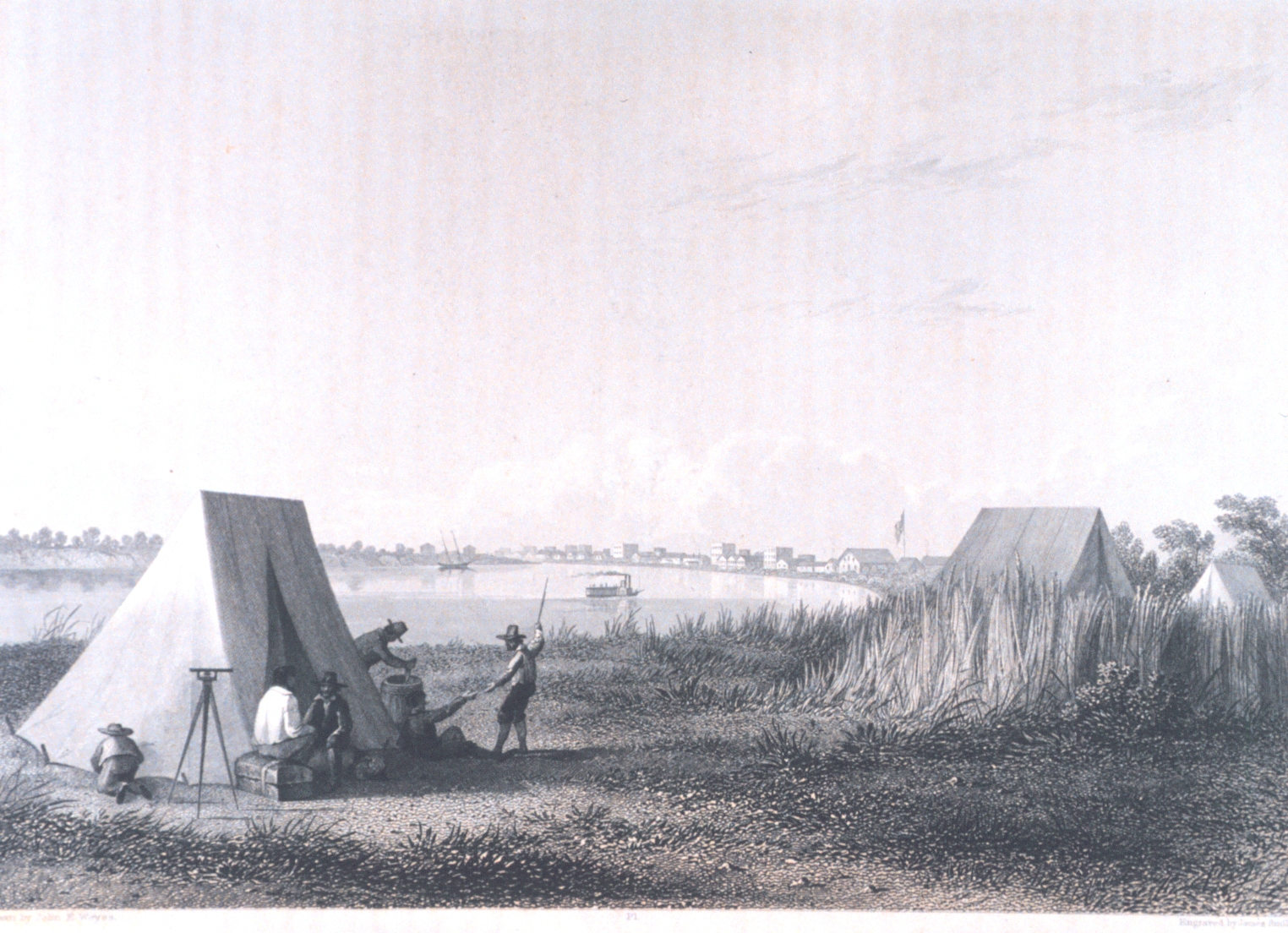
Brownsville, Texas. Polski: Brownsville w latach 50' XIX wieku
Svenska: Brownsville på 1850-talet
Dansk: Brownsville, Texas i 1850'erne
Norsk bokmål: Brownsville på 1850-tallet |
| Date | released 1857 |
| Source |
"United States and Mexican Boundary Survey. Report of William H. Emory ...." Washington. 1857. Volume I. P. 60. Library Call Number F786 .U45 1857.; NOAA photo library, Image ID: libr0141 |
| Author | William H. Emory, (Archival Photograph by Mr. Sean Linehan, NOS, NGS) |
| Permission (Reusing this file) |
Copyright expired as William H. Emory is clearly more than 70 years dead. |
Licensing
This image is in the public domain because it contains materials that originally came from the U.S. National Oceanic and Atmospheric Administration, taken or made as part of an employee's official duties.
|
This image was selected as picture of the day on Wikimedia Commons for 13 January 2005. It was captioned as follows: Other languages:
Deutsch: Die Stadt Brownsville in Süd-Texas (1850) Español: El poblado de Brownsville, en el sur de Texas (1850) Esperanto: La urbo Brownsville en suda Teksaso (1850) Italiano: La città di Brownsville nel sud del Texas (1850) Suomi: Brownsvillen kaupunki eteläisessä Texasissa vuonna 1850 |
nl:Afbeelding:Emory-Brownsville.jpg
File history
Click on a date/time to view the file as it appeared at that time.
| Date/Time | Thumbnail | Dimensions | User | Comment | |
|---|---|---|---|---|---|
| current | 21:40, 2 May 2005 | | 1,524 × 1,104 (1.15 MB) | Arnomane | higher resolution |
| 17:53, 6 October 2004 |  | 700 × 507 (62 KB) | Robbot | This image was copied from nl.wikipedia.org. The original description was: Brownsville, Texas. In: "United States and Mexican Boundary Survey. Report of William H. Emory ...." Washington. 1857. Volume I. Copied from: NOAA. {{PD}} [[nl:Afbeelding:Emo |
File usage
The following 3 pages use this file:
Global file usage
The following other wikis use this file:
- Usage on bg.wikipedia.org
- Usage on da.wikipedia.org
- Usage on de.wikipedia.org
- Usage on es.wikipedia.org
- Usage on fr.wikipedia.org
- Usage on ia.wikipedia.org
- Usage on ko.wikipedia.org
- Usage on no.wikipedia.org
- Usage on pl.wikipedia.org
- Usage on www.wikidata.org
You must be logged in to post a comment.