


Size of this PNG preview of this SVG file: 800 × 465 pixels. Other resolutions: 320 × 186 pixels | 640 × 372 pixels | 1,024 × 595 pixels | 1,280 × 744 pixels | 2,560 × 1,488 pixels | 1,020 × 593 pixels.
Original file (SVG file, nominally 1,020 × 593 pixels, file size: 29 KB)
| U.S. presidential election maps (SVG) |
| See also: National Atlas maps (png) |
|
1788-1789 · 1792 · 1796 · 1800 · 1804 · 1808 · 1812 · 1816 · 1820 · 1824 · 1828 · 1832 · 1836 · 1840 · 1844 · 1848 · 1852 · 1856 · 1860 · 1864 · 1868 · 1872 · 1876 · 1880 · 1884 · 1888 · 1892 · 1896 · 1900 · 1904 · 1908 · 1912 · 1916 · 1920 · 1924 · 1928 · 1932 · 1936 · 1940 · 1944 · 1948 · 1952 · 1956 · 1960 · 1964 · 1968 · 1972 · 1976 · 1980 · 1984 · 1988 · 1992 · 1996 · 2000 · 2004 · 2008 · 2012 · 2016 · 2020 · 2024 |
Summary
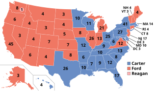
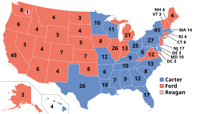
| Description | Electoral college results for 1976 U.S. presidential election (Ford-Carter) |
| Date | |
| Source | This image is based off en:Image:ElectoralCollege1992.svg from Wikipedia, which in turn is based off Image:Blank_US_Map.svg from the Commons. |
| Author | SteveSims |
| Other versions | See also Image:1976 Electoral College Map.png |
Licensing
| I, the copyright holder of this work, release this work into the public domain. This applies worldwide. In some countries this may not be legally possible; if so: I grant anyone the right to use this work for any purpose, without any conditions, unless such conditions are required by law. |
File history
Click on a date/time to view the file as it appeared at that time.
| Date/Time | Thumbnail | Dimensions | User | Comment | |
|---|---|---|---|---|---|
| current | 03:20, 27 February 2025 | | 1,020 × 593 (29 KB) | Interesting 2752 | Reverting mass reversion to old version of map |
| 20:45, 26 February 2025 |  | 1,020 × 593 (123 KB) | Ecotto29200 | Reverted to version as of 04:41, 15 September 2008 (UTC) | |
| 05:24, 19 January 2023 |  | 1,020 × 593 (29 KB) | Politicsfan4 | code | |
| 04:28, 23 December 2020 |  | 1,020 × 593 (29 KB) | Politicsfan4 | better color for Reagan, consistency with 2016 map for Kasich | |
| 13:08, 28 December 2018 |  | 1,020 × 593 (29 KB) | Newfraferz87 | Optimize | |
| 03:18, 17 September 2017 |  | 1,020 × 593 (35 KB) | Newfraferz87 | Cleanup | |
| 22:39, 2 December 2016 |  | 1,020 × 593 (46 KB) | Wow | DE | |
| 23:38, 13 November 2016 |  | 1,020 × 593 (46 KB) | Wow | DC | |
| 11:29, 18 November 2011 |  | 1,004 × 588 (93 KB) | Citypeek | removal line | |
| 04:41, 15 September 2008 |  | 1,020 × 593 (123 KB) | SteveSims~commonswiki | light red circle for Reagan's electoral vote |
File usage
The following 88 pages use this file:
- 1976 California Democratic presidential primary
- 1976 United States elections
- 1976 United States presidential election
- 1976 United States presidential election in Alabama
- 1976 United States presidential election in Alaska
- 1976 United States presidential election in Arizona
- 1976 United States presidential election in Arkansas
- 1976 United States presidential election in California
- 1976 United States presidential election in Colorado
- 1976 United States presidential election in Connecticut
- 1976 United States presidential election in Delaware
- 1976 United States presidential election in Florida
- 1976 United States presidential election in Georgia
- 1976 United States presidential election in Hawaii
- 1976 United States presidential election in Idaho
- 1976 United States presidential election in Illinois
- 1976 United States presidential election in Indiana
- 1976 United States presidential election in Iowa
- 1976 United States presidential election in Kansas
- 1976 United States presidential election in Kentucky
- 1976 United States presidential election in Louisiana
- 1976 United States presidential election in Maine
- 1976 United States presidential election in Maryland
- 1976 United States presidential election in Massachusetts
- 1976 United States presidential election in Michigan
- 1976 United States presidential election in Minnesota
- 1976 United States presidential election in Mississippi
- 1976 United States presidential election in Missouri
- 1976 United States presidential election in Montana
- 1976 United States presidential election in Nebraska
- 1976 United States presidential election in Nevada
- 1976 United States presidential election in New Hampshire
- 1976 United States presidential election in New Jersey
- 1976 United States presidential election in New Mexico
- 1976 United States presidential election in New York
- 1976 United States presidential election in North Carolina
- 1976 United States presidential election in North Dakota
- 1976 United States presidential election in Ohio
- 1976 United States presidential election in Oklahoma
- 1976 United States presidential election in Oregon
- 1976 United States presidential election in Pennsylvania
- 1976 United States presidential election in Rhode Island
- 1976 United States presidential election in South Carolina
- 1976 United States presidential election in South Dakota
- 1976 United States presidential election in Tennessee
- 1976 United States presidential election in Texas
- 1976 United States presidential election in Utah
- 1976 United States presidential election in Vermont
- 1976 United States presidential election in Virginia
- 1976 United States presidential election in Washington (state)
- 1976 United States presidential election in West Virginia
- 1976 United States presidential election in Wisconsin
- 1976 United States presidential election in Wyoming
- 1976 United States presidential election in the District of Columbia
- 1976 in the United States
- Electoral history of Bob Dole
- Electoral history of Jimmy Carter
- Electoral history of Ronald Reagan
- Electoral vote changes between United States presidential elections
- Gerald Ford
- Gerald Ford 1976 presidential campaign
- Jimmy Carter
- List of United States presidential election results by state
- Presidency of Gerald Ford
- Presidency of Jimmy Carter
- Solid South
- United States presidential election
- User:1aWIKIAL1,/sandbox
- User:DukeOfDelTaco/U.S. Presidential Elections
- User:Falcaorib/United States presidential elections
- User:GaemGeck/sandbox
- User:Hogne/us electioons
- User:Landon8964906/sandbox
- User:MushroomGorge/sandbox
- User:NewDealChief/sandbox
- User:PHRobertson/sandbox/sandbox
- User:Pasta 4431/sandbox
- User:RapidsLurker15/United States presidential elections
- User:Thatguy7447/sandbox
- Template:1976 United States presidential election imagemap
- Template:State results of the 1976 U.S. presidential election
- Draft:2040 United States presidential election
- Draft:2044 United States presidential election
- Draft:2048 United States presidential election
- Draft:2052 United States presidential election
- Draft:2056 United States presidential election
- Draft:2060 United States presidential election
- Draft:2064 United States presidential election
Global file usage
The following other wikis use this file:
- Usage on arz.wikipedia.org
- Usage on ast.wikipedia.org
- Usage on az.wikipedia.org
- Usage on ckb.wikipedia.org
- Usage on da.wikipedia.org
- Usage on de.wikipedia.org
- Usage on el.wikipedia.org
- Usage on en.wikibooks.org
- Usage on es.wikipedia.org
- Usage on fa.wikipedia.org
- Usage on fi.wikipedia.org
- Usage on fr.wikipedia.org
- Usage on he.wikipedia.org
- Usage on hu.wikipedia.org
- Usage on is.wikipedia.org
- Usage on it.wikipedia.org
- Usage on ja.wikipedia.org
- Usage on ka.wikipedia.org
- Usage on kk.wikipedia.org
- Usage on ko.wikipedia.org
- Usage on lt.wikipedia.org
- Usage on lv.wikipedia.org
- Usage on ml.wikipedia.org
- Usage on no.wikipedia.org
- Usage on pl.wikipedia.org
- Usage on pt.wikipedia.org
- Usage on ro.wikipedia.org
View more global usage of this file.
You must be logged in to post a comment.