


Size of this preview: 800 × 274 pixels. Other resolutions: 320 × 110 pixels | 640 × 219 pixels | 1,905 × 653 pixels.
Original file (1,905 × 653 pixels, file size: 58 KB, MIME type: image/png)
Summary
| Description |
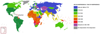
Español: Mapamundi que muestra en qué época se independizaron los países
English: World map that shows in which time the countries gained independence |
| Date | |
| Source | Own work |
| Author | Universalis |
Licensing
I, the copyright holder of this work, hereby publish it under the following license:
This file is licensed under the Creative Commons Attribution-Share Alike 4.0 International license.
- You are free:
- to share – to copy, distribute and transmit the work
- to remix – to adapt the work
- Under the following conditions:
- attribution – You must give appropriate credit, provide a link to the license, and indicate if changes were made. You may do so in any reasonable manner, but not in any way that suggests the licensor endorses you or your use.
- share alike – If you remix, transform, or build upon the material, you must distribute your contributions under the same or compatible license as the original.
File history
Click on a date/time to view the file as it appeared at that time.
| Date/Time | Thumbnail | Dimensions | User | Comment | |
|---|---|---|---|---|---|
| current | 19:50, 27 May 2022 | 1,905 × 653 (58 KB) | Universalis | Uploaded own work with UploadWizard |
File usage
The following 4 pages use this file:
Global file usage
The following other wikis use this file:
- Usage on id.wikipedia.org
- Usage on ja.wikipedia.org
- Usage on ko.wikipedia.org
- Usage on min.wikipedia.org
- Usage on sq.wikipedia.org
- Usage on zh.wikipedia.org
You must be logged in to post a comment.