


The Graphics Lab is a project to improve the graphical content of the Wikimedia projects. Requests for image improvements can be added to the workshop pages: Illustrations, Photographs and Maps. For questions or suggestions one can use the talk pages: Talk:Graphics Lab, Talk:Illustrations, Talk:Photographs and Talk:Maps.
This specific page is the requests page for the Map workshop. Anyone can make a request for a map to be created or improved for a Wikipedia article. The standard format for making a request is shown below, along with general advice, and should be followed.
You are encouraged to share information and request advice from others. Also see possible conventions toolbox, map tutorials and topographic map tutorials.
| Advice to requesters |
|---|
|
What do we do?
|


| Result | Code | Usage |
|---|---|---|
{{resolved}} ~~~~
|
Mark a thread as resolved and request archiving | |
{{subst:bump}}
|
Delay automatic archiving of a section for 30 days | |
{{I take|~~~~}}
|
When you'll be working on the request | |
{{Done}} ~~~~
|
When the request is done |
This page is automatically archived by ClueBot III. | |
Request: Silk Route Map

-
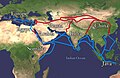 Extent of Silk Route/Silk Road. Red is land route and the blue is the sea/water route.

- Article(s)
- 61 pages use this file
- Request
- Please reduce the thickness of the lines (red and blue). Looks very much amateur. This image is in use in 61 articles. JamesMdp (talk) 13:11, 23 January 2025 (UTC)
- Discussion
- @JamesMdp Is there a reason this file could not be replaced with the many better ones we have on Wikimedia Commons, such as File:Silk Road in the I century AD - en.svg. Is there something specific about this media that others lack? – Isochrone (talk) 16:03, 15 February 2025 (UTC)
- The file is supposed to be a "simple" view of the silk road and spice routes (without too many marked locations and rivers, etc. - to give the reader a "level 1" understanding of the subject). The image is fine for the basic reader. But it looks very much amateur. Please reduce the thickness of the lines (red and blue) and keep all labels in same font size. Thanks! JamesMdp (talk) 04:19, 16 February 2025 (UTC)
Inca Empire's territorial extension under Pachacuti
-
 John Howland Rowe's map of Inca Expansion (Note: "Tupac Inca (1463–1471)" describes territories conquered by Tupac under Pachacuti's reign, while "Tupac Inca (1471–91)" took place under Tupac's reign, after Pachacuti's)
 -
 Map of Inca provinces, which corresponded roughly to pre-Inca chiefdoms (Note:the former Chimu empire, shown in yellow, was separated in many parts by the Incas).
 -

-
 Similar map to the one requested, but based on different source (Rowe)


- Article(s)
- Pachacuti, Inca Empire, History of the Incas
- Request
- Would it be possible to create a map of Inca territory at the end of Pachacuti's reign based on Martti Pärssinen's map of Inca expansion, which was reused by other researchers?
- While the traditional map is that of John Howland Rowe (made in 1945), Pärssinen's analysis is more recent (1992), and was reused by Terence N. D'Altroy in "The Incas" (Wiley-Blackwell), a work of reference, and by Carmen Bernand. In addition, Pärssinen's map corresponds better to the order of expansion of the Inca Empire told by María Rostworowski in her biography of Pachacuti (1953, Pachacútec Inca Yupanqui), the main reference for Pachacuti's reign. Rostworowski did not add a map to her work, sadly. The difference between Pärssinen and Rowe is mainly that with Pärssinen, emperor Pachacuti conquered beyond the Río Desaguadero up to lake Poopó (while Rowe makes the desguadero the Inca border under Pachacuti), a detail where Rostworowski agrees with Pärssinen in her biography of Pachacuti (in that she wrote that Pachacuti conquered those regions). This difference is not the same as two simple colonial chroniclers disagreeing on a matter, since it is a debate between modern academics. Pärssinen's interpretation deserves, in my opinion, it's representation on Wikipedia, to inform readers on other opinions than John Rowe's, especially since Rostworowski's biography of Pachacuti is the most important work on his reign. My request is to create a map of the empire at the end of Pachacuti's reign, without the expansion under other emperors shown (they are shown in the original map linked below). Maybe, if it is not too much, it would be possible to add some important ethnic groups outside of the Inca empire. The original map to base this map on is available here: It is page 139, and the territory necessary for the map I am requesting here is described in the legend under "The conquest of Pachacuti, together with Capac Yupanqui, Topa Inca, Amaro Topa, etc.". Thank you for reading. -- 80.187.71.65 (talk) 12:27, 29 January 2025 (UTC)
- Apparently my proposition is not very popular, I fear I might have done something wrong in formatting, the first image says "Wp:NFCC", could anyone help? Regards. 2A01:599:A0C:A709:FC88:EB46:2B7D:C833 (talk) 19:36, 16 February 2025 (UTC)
- I probably made some error in formatting, considering the lack of responses… 80.187.71.187 (talk) 00:40, 26 February 2025 (UTC)
- Discussion
State atheism
-
 Map including East Germany and South Yemen

- Article(s)
- State atheism
- Request
- This is a version of human-editable map of State atheism using present-day borders. I've added East Germany and South Yemen using BlankMap-World 1985. Nevertheless, there are small problems in rendering these two additional countries (e.g. position, scale, and South Yemen white border). Could you help me fix them? -- Carnby (talk) 08:45, 10 February 2025 (UTC)
- Discussion
Request: Map of the Hittites based on a reliable source
-
 An example image

- Article(s)
- Hittites, Turkey, etc
- Request
- This journal article (accessible through the Wikipedia Library) has a map of the Hittites ("Fig. 1. Map of the Hittite domain, with the Taurus marked"). The same map is also available in Researchgate [1]. The journal article has a CC BY-NC-ND 4.0 licence. Can someone adjust the above map based on the source or create a new image? Bogazicili (talk) 16:33, 21 February 2025 (UTC)
- Discussion
Ukraine gas transit: vectorise and simplify

- Article(s)
- Natural gas transmission system of Ukraine
- Request
- To make this map look better and easy to translate it would be great if you could
1) Crop off everything west of Kyiv
2) Remove all towns and cities except Kyiv, Odesa and Lviv
3) Remove Prypats River
4) Convert to svg
5) Add in small inconspicuous font: Source: tsoua.com/en/news/a-new-phase-of-the-vertical-corridor-initiative-to-launch-in-july-2024/
If it is easier for you to simply draw a new one based on the source please do so. Or if you have other suggestions I will be happy to hear them.
Do you think this request should be combined with the one below?
-- Chidgk1 (talk) 17:17, 24 February 2025 (UTC)
- Discussion
- Hi @Chidgk1, would you mind providing some sources for a map like this, as you have done below? – Isochrone (talk) 12:59, 2 March 2025 (UTC)
- @Isochrone As well as the official source mentioned in 5) above there is also a map on page 3 of https://s3.eu-west-1.amazonaws.com/icis.ada.website.live/wp-content/uploads/2024/05/03170057/ICIS_VerticalCorridor_April2024.pdf Is that what you are asking for? Chidgk1 (talk) 13:03, 3 March 2025 (UTC)
Balkans gas transit: shrink and correct

- Article(s)
- Balkan Stream
- Request
- I tried to use https://commons.wikimedia.org/wiki/Commons:SVG_Translate_tool to add English to this map but was unsuccessful - apparently the text is in pixels and it may be too big for the tool. I asked the original author for the source but no reply yet - the Bulgarian part may be the map on p74 (last page) of https://www.bulgartransgaz.bg/files/useruploads/files/amd/TYNDP%202020-2029%20EN.pdf
Please could you correct it so that I can translate it. Also please could you correct the coloring: from the map on page 14 of https://www.energy-community.org/dam/jcr:2d6dbbe2-97a7-4643-a187-b71c7e82f002/Improvement%20of%20the%20commercial%20attractiveness%20of%20the%20Trans-Balkan%20pipeline%20system%20-%20Analytical%20and%20Recommendations%20Report.pdf we know the Trans-Balkan pipeline (dark blue) goes all the way from Turkey to Ukraine.
Also it would be great if you could label Turkstream, Trans-Balkan pipeline and Balkan Stream next to the lines rather than as a legend.
Do you think this request should be combined with the one above?
-- Chidgk1 (talk) 17:46, 24 February 2025 (UTC)
- Unfortunately I have not been able to find a reliable source for the Serbian and Hungarian parts so perhaps it should only be drawn in Bulgaria for now Chidgk1 (talk) 13:14, 3 March 2025 (UTC)
- Discussion
Requesting for help with Togo Location Map for Prefectures
-
 example in Maritime region of Togo of what is required (or, if possible, an .svg map locator), but my map editing skill is not good at all for the task

- Article(s)
- Prefectures of Togo
- Request
- Requesting a map please for the prefectures of Togo (and, possible, maps per each of 5 regions divided into prefectures) with a purpose to be used as map locator in articles about Togo prefectures. In 2016, a change in prefectures happened and their numbers increased. The old maps became obsolete in 2 regions (Maritime and Savanes regions; Kara region is fine for example) and many maps weren't up to the task. A reference for the new prefecture borders can be seen here (scalable and dynamic map) or at site of census institution INSEED, they were stable enough (census in 2022 and local elections in 2019). Category of locators in wikicommons: Category:Locator maps of prefectures of Togo, Category:Maps of prefectures of Togo. I do not request to make canton maps, just proper region-prefecture maps to replace illustrations like these: File:Savanes prefectures.png Thank you for listening and hope that someone would be interested to help. -- Duppertip (talk) 21:19, 26 February 2025 (UTC)
- Discussion
- @Duppertip I misunderstood your request and made maps of the regions File:Togo Plateaux Region locator map (2016).svg etc. (all in c:Category:SVG locator maps of Regions in Togo (location map scheme). I'll have to look into the prefectures but I'm a bit tight for time recently. Sorry about that, at least you have some region maps with slightly better boundaries. – Isochrone (talk) 20:47, 1 March 2025 (UTC)
- I am sorry for the misunderstanding, I should have worded it better myself. Thank you for the region locator maps, they are a great update. Duppertip (talk) 21:07, 1 March 2025 (UTC)
Request for maps of Cumberland and Westmorland and Furness unitary authority areas
- Article(s)
- Would be used in hundreds of articles which currently link to the old districts, villages, hamlets, civil parishes etc in Cumbria, England.
- Request
In 2023 Cumbria, England was reorganised into two unitary authorities, Cumberland and Westmorland and Furness. The six districts were merged into these two new areas.
A number of articles use District maps for the former areas, which now are defunct.
To replace File:Location map United Kingdom Allerdale.svg, File:Location map Borough of Copeland.svg and File:Location map United Kingdom City of Carlisle.svg a map for the new Cumberland district is required.
To replace File:Location map United Kingdom Eden.svg, File:Location map United Kingdom South Lakeland.svg and File:Location map United Kingdom Borough of Barrow-in-Furness.svg a map for the new Westmorland and Furness district is required.
The inset maps on the current maps use File:Cumbria UK district map 2010 (blank).svg, I would suggest using File:Cumbria UK district map 2023 (blank).svg instead.
Many thanks in advance. Thirdman (talk) 00:06, 7 March 2025 (UTC)
- Discussion
Request

-
 Holocaust map
 -
Description of second image (if needed)Description of second image (if needed)
-
Description of third image (if needed; don't request too many at once, though)Description of third image (if needed; don't request too many at once, though)
- Article(s)
- Legality of Holocaust denial
- Request
- Details of your request go here... -- Sweden should be pink, as it recently passed a law outlawing Holocaust denial/questioning, but it won't take effect until 2027. — Preceding unsigned comment added by Admiral Farmer (talk • contribs)
- Discussion
- @Admiral Farmer
 Done – Isochrone (talk) 19:59, 20 March 2025 (UTC)
Request: New Location maps of Angola are needed. Province and municipal division was changed in August 2024.
-
 Outdated Location Map of Angola. New additional border lines are needed: a) Cuando Cubango Province was split into two provinces. b) New Icolo e Bengo Province was separated from earlier much larger Luanda Province. c) Moxico Leste Province (i.e. East Moxico) was separated from Moxico Province.
 -
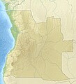 Relief locator with outdated administrative borders. Same corrections are needed as in previous map.
 -
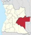 Example of outdated location map of a province. Eastern part of this Moxico Province is now Moxico Leste. In practice, all 21 provinces need new location maps.


- Article(s)
- Very many geography related articles of Angola. For example, all maps of the article Provinces of Angola needs to be updated with new administrative borders. All articles of current provinces of Angola need a new location map. Cities and other locations in Angola typically use Template:Location map, and the background maps of Angola used needs to be updated. Perhaps this one replaces the existing administrative and topographic maps of Angola used in the country template, with newer ones?
- Request
- The Law on the political-administrative division of Angola of 22 August 2024 changed the provincial and local division of the country.[1] As a result, Angola now has 21 provinces instead of 18, and the number of municipalities has almost doubled from 164 to 326.[1][2] You can read about this e.g. in Provinces of Angola, and in some other wikipedias like fi:Angolan maakunnat (and about current municipalities: fi:Angolan kunnat), which have updated their content already.
- The Angolan law 14/24 describes the boundaries of each administrative region, province by province and municipality by municipality. I found that only few news media published a map showing the main features of the new regional division, here is one which could help: [3] Unfortunately, some of the official publications, like the presidential decree 268/24, included a map with distorted proportions (Angola has been flattened in a north-south direction).[4]
- As a result, at the very least, the general administrative and topographical map of Angola should be renewed (c:Category:Location maps of Angola). As a next step, these should be updated in the relevant map template used in pushpin maps for Angola (Angola#Africa). The articles of municipalities (município) or their possible subdivisions (comuna), including cities, towns and other populated places, typically use these pushpin maps. Then, the maps showing the location of each province (c:Category:SVG locator maps of provinces in Angola (location map scheme)), should be updated, to reflect the new administrative division. It has already entered into force in principle, although the change will be implemented gradually over the period 2025-2027. If possible, consider creating 1-2 maps also in the c:Category:SVG labeled maps of administrative divisions of Angola (location map scheme)? At some point, also the Angola map covering the 326 municipalities could be generated, but I think this is not the most urgent issue.
BR, -- Paju~enwiki (talk) 05:10, 21 March 2025 (UTC)
References
- ^ a b "Lei n.º 14/24 - Lei da Divisão Político-Administrativa" [Law on the Political-Administrative Division of Angola (Law 14 of 2024)]. Portal da Legislação Angolana, angolex.com (in Portuguese). Luanda. 2024-08-22. Retrieved 2025-03-21.
- ^ "Division of the country into 21 provinces projects "population-balance"". Ver Angola, verangola.net. 2024-09-13. Retrieved 2025-03-21.
- ^ "Governo apresenta novo mapa com 21 províncias – Moxico continua sendo a maior do país" [Government presents new map with 21 provinces – Moxico continues to be the largest in the country]. diarioindependente.info (in Portuguese). 2024-08-15. Retrieved 2025-03-21.
- ^ "Decreto Presidencial n.º 268/24 de 29 de novembro" [Presidential Decree n.º 268/24 of November 29] (PDF). Diaro da Republica, files.lex.ao (in Portuguese). Luanda. 2024-11-29. Retrieved 2025-03-21.
- Discussion
Hi. I was just wondering if there were an easy way to get current administrative borders.. But e.g. website https://www.topogis-ao.com/arquivos-sig-e-cad seems to have shapefiles of the old DPA division of Angola, the new is not yet there... This website suggests, that their data originated from: (Portuguese: Ministério da Administração do Território). Perhaps someone who speaks Portuguese could contact the ministry and ask for an update? It would be also in their interest that Wikipedia updates the maps of Angola.
On the same occasion, it is definitely worth asking what the ministry considers to be the area of each province in square kilometres (and as a check, ask for the total area of the state). The argument could be that numerous official websites (such as https://governo.gov.ao/angola/provincias, and the provincial websites linked to it) currently have incorrect information about the area of many provinces even before the new political-administrative division.
However, I think the correct data could be requested directly from the national geodetic institute. In Angola the national geodetic (mapping research) institute is (Portuguese: Instituto Geográfico e Cadastral de Angola, IGCA, https://www.igca.gov.ao/; earlier also Portuguese: Instituto Geodesía e Cartografia de Angola, per https://www.igca.gov.ao/historia). It works under the Ministry of Planning, Urbanism, and Construction (Portuguese: Ministério das Obras Públicas, Urbanismo e Habitação, MINOPUH, https://minopuh.gov.ao/). I currently cannot access e.g. ESRI ArcGIS license which I could use for free commercial purposes, so I request that somebody else could do this... --Paju~enwiki (talk) 06:29, 21 March 2025 (UTC)
- As no response came here, this request was sent to Commons User:NordNordWest. --Paju~enwiki (talk) 02:25, 27 March 2025 (UTC)
Maps of "His Majesty's dominions" and the "British possessions"
-
Map of His Majesty's dominionsMap of His Majesty's dominions
-
Map of the British possessionsMap of the British possessions
- Article(s)
- British possession
- Request
Please create maps of the countries encompassed in the legal definition of "His Majesty's dominions" and "British possessions". The former definition (not to be confused with the much more restrictive historical definition of a "Dominion") is everywhere where the British monarch is head of state: the Commonwealth realms, the Crown Dependencies, the British Overseas Territories, and all the dependent territories of countries like Australia and New Zealand (including their respective Antarctic claims). The latter definition is almost the same but does not include the UK (Great Britain and Northern Ireland) itself. Neither definition includes Barbados, so the map should be dated after 2022, when that country abolished its monarch and became a republic. Both maps should include the boundaries of Canadian provinces and Australian states.
I tried to do this myself but I found that I wasn't able to because the maps from which I tried to work (File:BlankMap-World.svg and File:Blank Map World Secondary Political Divisions.svg) seemed to be missing some territories; the former seems to be missing the British Indian Ocean Territory and the latter seems to be missing Bermuda. One of them (I forgot which) is also missing the Australian dependency of Christmas Island and possibly others. The wisest fool in Christendom (talk) 22:28, 24 March 2025 (UTC)
- Discussion
Map
- Article(s)
- British National Party
- British National Party election results
- History of the British National Party
- Far-right politics in the United Kingdom
- Request
- I am just wondering can somebody make a map of the 2010 UK election constituencies results like this https://en.wikipedia.org/wiki/File:2010_UK_Election_Respect_results.svg, for the British National Party. The Darker the color (Blue), the Higher the % the party got. Here are the results for the constituencies.
| Constituency | Candidate | Votes | % |
|---|---|---|---|
| Aberavon | Kevin Edwards | 1,276 | 4.1 |
| Aberdeen North | Roy Jones | 635 | 1.7 |
| Aberdeen South | Susan Ross | 529 | 1.2 |
| Aberdeenshire West & Kincardine | Gary Raikes | 513 | 1.1 |
| Alyn and Deeside | John Walker | 1,368 | 3.4 |
| Amber Valley | Michael Clarke | 3,195 | 7.0 |
| Ashfield | Edward Holmes | 2,781 | 5.8 |
| Ashton-under-Lyne | David Lomas | 2,929 | 7.6 |
| Banff and Buchan | Richard Payne | 1,010 | 2.6 |
| Barking | Nick Griffin | 6,620 | 14.6 |
| Barnsley Central | Ian Sutton | 3,307 | 8.9 |
| Barnsley East | Colin Porter | 3,301 | 8.6 |
| Barrow and Furness | Mike Ashburner | 840 | 1.9 |
| Basildon and Billericay | Irene Bateman | 1,934 | 4.6 |
| Basildon South and Thurrock East | Chris Roberts | 2,518 | 5.6 |
| Batley and Spen | David Exley | 3,685 | 7.1 |
| Beckenham | Roger Tonks | 1,001 | 2.1 |
| Bedford | William Dewick | 757 | 1.7 |
| Bedfordshire North East | Ian Seeby | 1,265 | 2.3 |
| Bedfordshire South West | Mark Tolman | 1,703 | 3.4 |
| Bermondsey and Old Southwark | Stephen Tyler | 1,370 | 3.1 |
| Berwick-upon-Tweed | Peter Mailer | 1,213 | 3.2 |
| Bethnal Green and Bow | Jeffrey Marshall | 1,405 | 2.8 |
| Beverley and Holderness | Neil Whitelam | 2,080 | 3.9 |
| Bexhill and Battle | Neil Jackson | 1,950 | 3.6 |
| Bexleyheath and Crayford | Stephen James | 2,042 | 4.7 |
| Birmingham Edgbaston | Trevor Lloyd | 1,196 | 2.9 |
| Birmingham Erdington | Kevin McHugh | 1,815 | 5.1 |
| Birmingham Hodge Hill | Richard Lumby | 2,333 | 5.5 |
| Birmingham Northfield | Les Orton | 2,290 | 5.5 |
| Birmingham Selly Oak | Lynette Orton | 1,820 | 3.9 |
| Birmingham Yardley | Tanya Lumby | 2,153 | 5.3 |
| Bishop Auckland | Adam Walker | 2,036 | 4.9 |
| Blackburn | Robin Evans | 2,158 | 4.7 |
| Blackley and Broughton | Derek Adams | 2,469 | 7.2 |
| Blackpool North & Cleveleys | James Clayton | 1,556 | 3.8 |
| Blackpool South | Roy Goodwin | 1,482 | 4.2 |
| Blaenau Gwent | Anthony King | 1,211 | 3.7 |
| Blaydon | Keith McFarlane | 2,277 | 5.1 |
| Blyth Valley | Steve Fairburn | 1,699 | 4.4 |
| Bognor Regis and Littlehampton | Andrew Moffat | 1,890 | 4.0 |
| Bolsover | Martin Radford | 2,640 | 6.0 |
| Bolton South East | Shelia Spink | 2,012 | 5.1 |
| Bootle | Charles Stewart | 942 | 2.3 |
| Boston and Skegness | David Owens | 2,278 | 5.3 |
| Bosworth | John Ryde | 2,458 | 4.5 |
| Bracknell | Mark Burke | 1,253 | 2.4 |
| Bradford East | Neville Poynton | 1,854 | 4.6 |
| Bradford South | Sharon Sutton | 2,651 | 7.0 |
| Bradford West | Jenny Sampson | 1,370 | 3.4 |
| Braintree | Paul Hooks | 1,080 | 2.2 |
| Brentford and Isleworth | Paul Winnet | 704 | 1.3 |
| Brentwood and Ongar | Paul Morris | 1,447 | 2.9 |
| Bridgend | Brian Urch | 1,020 | 2.7 |
| Bridgwater and West Somerset | Donna Treanor | 1,282 | 2.4 |
| Brigg and Goole | Steve Ward | 1,498 | 3.4 |
| Bristol East | Brian Jenkins | 1,960 | 4.4 |
| Bristol South | Colin Chidsey | 1,739 | 3.6 |
| Broadland | Edith Crowther | 871 | 1.7 |
| Bromley and Chislehurst | Rowena Savage | 1,070 | 2.4 |
| Bromsgrove | Elizabeth Wainwright | 1,923 | 3.7 |
| Broxbourne | Steve McCole | 2,159 | 4.7 |
| Broxtowe | Michael Shore | 1,422 | 2.7 |
| Buckingham | Lynne Mozar | 980 | 2.0 |
| Burnley | Sharon Wilkinson | 3,747 | 9.0 |
| Burton | Alan Hewitt | 2,409 | 4.8 |
| Bury North | John Maude | 1,825 | 4.1 |
| Bury South | Jean Purdy | 1,743 | 3.6 |
| Caerphilly | Laurence Reid | 1,635 | 4.2 |
| Calder Valley | John Gregory | 1,823 | 3.5 |
| Cambridgeshire North East | Susan Clapp | 1,747 | 3.3 |
| Cannock Chase | Terence Majorowicz | 2,168 | 4.8 |
| Carlisle | Paul Stafford | 1,086 | 2.6 |
| Carshalton and Wallington | Charlotte Lewis | 1,100 | 2.4 |
| Castle Point | Phil Howell | 2,205 | 4.9 |
| Charnwood | Cathy Duffy | 3,116 | 5.8 |
| Chatham and Aylesford | Colin McCarthy-Stewart | 1,365 | 3.1 |
| Chelmsford | Mike Bateman | 899 | 1.6 |
| Cheslea and Fulham | Brian MacDonald | 388 | 1.0 |
| Chingford and Woodford Green | Julian Leppert | 1,288 | 3.0 |
| Chippenham | Michael Simpkins | 641 | 1.2 |
| Clacton | Jim Taylor | 1,975 | 4.6 |
| Clwyd South | Sarah Hynes | 1,100 | 3.2 |
| Colchester | Sidney Chaney | 705 | 1.5 |
| Colne Valley | Barry Fowler | 1,893 | 3.4 |
| Copeland | Clive Jefferson | 1,474 | 3.4 |
| Corby | Roy Davies | 2,525 | 4.7 |
| Coventry North East | Tom Gower | 1,863 | 3.4 |
| Coventry North West | Edward Sheppard | 1,666 | 3.6 |
| Crawley | Richard Trower | 1,672 | 3.5 |
| Crewe and Nantwich | Phil Williams | 1,043 | 2.0 |
| Croydon Central | Cliff Le May | 1,448 | 2.9 |
| Dagenham and Rainham | Michael Barnbrook | 4,952 | 11.2 |
| Darlington | Amanda Foster | 1,262 | 2.9 |
| Delyn | Jennifer Matthys | 844 | 2.3 |
| Derby North | Peter Cheeseman | 2,000 | 4.4 |
| Derbyshire Mid | Lewis Allsebrook | 1,698 | 3.6 |
| Derbyshire South | Peter Jarvis | 2,193 | 4.3 |
| Devon North | Gary Marshall | 614 | 1.2 |
| Devon West and Torridge | Nick Baker | 766 | 1.4 |
| Dewsbury | Roger Roberts | 3,265 | 6.0 |
| Don Valley | Erwin Toseland | 2,112 | 4.9 |
| Doncaster Central | John Bettney | 1,762 | 4.2 |
| Doncaster North | Pamela Chambers | 2,818 | 6.8 |
| Dover | Dennis Whiting | 1,104 | 2.2 |
| Dudley North | Ken Griffiths | 1,899 | 4.9 |
| Durham, City of | Ralph Musgrave | 1,153 | 2.5 |
| Durham North | Peter Molloy | 1,686 | 4.1 |
| Durham North West | Michael Stewart | 1,852 | 4.2 |
| Ealing North | Dave Furness | 1,045 | 2.2 |
| Easington | Cheryl Dunn | 2,317 | 6.6 |
| Eastbourne | Colin Poulter | 939 | 1.8 |
| Elmet and Rothwell | Sam Clayton | 1,802 | 3.2 |
| Eltham | Roberta Woods | 1,745 | 4.2 |
| Enfield North | Tony Avery | 1,228 | 2.8 |
| Epping Forest | Patricia Richardson | 1,982 | 4.3 |
| Erewash | Mark Bailey | 2,337 | 4.9 |
| Erith and Thamesmead | Kevin Saunders | 2,184 | 5.1 |
| Exeter | Robert Farmer | 673 | 1.3 |
| Feltham and Heston | John Donnelly | 1,714 | 3.5 |
| Filton and Bradley Stoke | David Scott | 1,328 | 2.7 |
| Folkestone and Hythe | Harry Williams | 1,662 | 3.1 |
| Gainsborough | Malcolm Porter | 1,512 | 3.1 |
| Gateshead | Kevin Scott | 1,787 | 4.7 |
| Gedling | Stephen Adcock | 1,598 | 3.3 |
| Gillingham and Rainham | Brian Ravenscroft | 1,149 | 2.5 |
| Glasgow Central | Ian Holt | 616 | 2.0 |
| Glasgow East | Joseph Finnie | 677 | 2.1 |
| Glasgow North | Thomas Main | 296 | 1.0 |
| Glasgow North East | Walter Hamilton | 798 | 2.7 |
| Glasgow North West | Scott McLean | 699 | 2.0 |
| Glasgow South | Mike Coyle | 637 | 1.6 |
| Glasgow South West | David Orr Jnr | 841 | 2.6 |
| Gordon | Elise Jones | 699 | 1.4 |
| Gosport | Barry Bennett | 1,004 | 2.1 |
| Gower | Adrian Jones | 963 | 2.3 |
| Grantham and Stamford | Christopher Robinson | 2,485 | 4.7 |
| Great Grimsby | Steve Fyfe | 1,517 | 4.6 |
| Great Yarmouth | Bosco Tann | 1,421 | 3.3 |
| Greenwich and Woolwich | Lawrence Rustem | 1,151 | 2.8 |
| Halifax | Tom Bates | 2,760 | 6.3 |
| Haltemprice and Howden | James Cornell | 1,583 | 3.2 |
| Halton | Andrew Taylor | 1,563 | 3.8 |
| Hammersmith | Lawrence Searle | 432 | 0.9 |
| Hampstead and Kilburn | Victoria Moore | 328 | 0.6 |
| Harborough | Geoff Dickens | 1,715 | 3.1 |
| Harlow | Eddy Butler | 1,739 | 4.0 |
| Harrogate and Knaresborough | Steven Gill | 1,094 | 2.1 |
| Hartlepool | Ronnie Bage | 2,002 | 5.2 |
| Harwich and North Essex | Stephen Robey | 1,065 | 2.2 |
| Hastings and Rye | Nicholas Prince | 1,310 | 2.6 |
| Hayes and Harlington | Chris Forster | 1,520 | 3.6 |
| Hemel Hempstead | Janet Price | 1,615 | 3.3 |
| Hemsworth | Ian Kitchen | 3,059 | 7.0 |
| Henley | John Bews | 1,020 | 1.9 |
| Hereford & Herefordshire South | John Oliver | 986 | 2.0 |
| Hertford and Stortford | Roy Harris | 1,297 | 2.3 |
| Hertfordshire South West | Deirdre Gates | 1,302 | 2.3 |
| Hertsmere | Daniel Seabrook | 1,397 | 3.0 |
| Hexham | Quentin Hawkins | 1,205 | 2.8 |
| Heywood and Middleton | Peter Greenwood | 3,239 | 7.0 |
| Holborn and St Pancras | Robert Carlyle | 779 | 1.4 |
| Hornchurch and Upminster | William Whelpley | 3,421 | 6.4 |
| Houghton and Sunderland South | Karen Allen | 1,961 | 5.4 |
| Huddersfield | Rachel Firth | 1,563 | 3.9 |
| Hyndburn | David Shapcott | 2,137 | 5.0 |
| Ilford North | Danny Warville | 1,545 | 3.3 |
| Ipswich | Dennis Boater | 1,270 | 2.7 |
| Isle of Wight | Geof Clynch | 1,457 | 2.1 |
| Islwyn | John Voisey | 1,320 | 3.8 |
| Jarrow | Andy Swaddle | 2,709 | 7.0 |
| Keighley | Andrew Brons | 1,962 | 4.1 |
| Kettering | Clive Skinner | 1,366 | 2.9 |
| Kingston upon Hull North | John Mainprize | 1,443 | 4.3 |
| Kingston upon Hull West and Hessle | Edward Scott | 1,416 | 4.5 |
| Kingswood | Michael Carey | 1,311 | 2.7 |
| Knowsley | Steven Greenhalgh | 1,895 | 4.2 |
| Lancaster and Fleetwood | Debra Kent | 938 | 2.2 |
| Leeds Central | Kevin Meeson | 3,066 | 8.2 |
| Leeds East | Trevor Brown | 2,947 | 7.8 |
| Leeds North East | Tom Redmond | 758 | 1.6 |
| Leeds North West | Geoffrey Bulmer | 766 | 1.8 |
| Leeds West | Joanna Beverley | 2,377 | 6.1 |
| Leicester East | Colin Gilmore | 1,700 | 3.5 |
| Leicester South | Adrian Waudby | 1,418 | 3.0 |
| Leicester West | Gary Reynolds | 2,158 | 6.0 |
| Leicestershire North West | Ian Meller | 3,396 | 6.5 |
| Leicestershire South | Paul Preston | 2,721 | 5.0 |
| Leigh | Gary Chadwick | 2,724 | 5.8 |
| Lewes | David Lloyd | 594 | 1.2 |
| Leyton and Wanstead | Jim Clift | 561 | 1.4 |
| Lincoln | Robert West | 1,367 | 3.0 |
| Liverpool Riverside | Peter Stafford | 706 | 1.8 |
| Liverpool Walton | Peter Stafford | 1,104 | 3.2 |
| Liverpool Wavertree | Steven McEllenborough | 150 | 0.4 |
| Livingston | David Orr | 960 | 2.0 |
| Loughborough | Kevan Stafford | 2,040 | 3.9 |
| Louth and Horncastle | Julia Green | 2,199 | 4.4 |
| Ludlow | Christina Evans | 1,016 | 2.1 |
| Luton North | Shelley Rose | 1,316 | 3.1 |
| Luton South | Tony Blakey | 1,299 | 3.1 |
| Maidenhead | Tim Rait | 825 | 1.5 |
| Makerfield | Ken Haslam | 3,229 | 7.4 |
| Maldon | Len Blaine | 1,454 | 3.1 |
| Manchester Central | Tony Trebilcock | 1,636 | 4.1 |
| Mansfield | Rachel Hill | 2,108 | 4.4 |
| Meriden | Frank O'Brien | 2,511 | 4.8 |
| Merthyr Tydfil and Rhymney | Richard Barnes | 1,173 | 3.7 |
| Middlesbrough | Michael Ferguson | 1,954 | 5.8 |
| Middlesbrough South and Cleveland East | Shaun Gatley | 1,576 | 3.4 |
| Milton Keynes North | Richard Hamilton | 1,154 | 2.1 |
| Milton Keynes South | Matthew Tait | 1,502 | 2.7 |
| Mitcham and Morden | Tony Martin | 1,386 | 3.2 |
| Morley and Outwood | Chris Beverley | 3,535 | 7.2 |
| Neath | Michael Green | 1,342 | 3.6 |
| Newcastle upon Tyne Central | Ken Booth | 2,302 | 6.7 |
| Newcastle upon Tyne East | Alan Spence | 1,342 | 3.5 |
| Newcastle upon Tyne North | Terry Gibson | 1,890 | 4.3 |
| Newport East | Keith Jones | 1,168 | 3.4 |
| Newport West | Timothy Windsor | 1,183 | 3.0 |
| Norfolk Mid | Christine Kelly | 1,261 | 2.5 |
| Norfolk North West | David Fleming | 1,839 | 3.8 |
| Norfolk South | Helen Mitchell | 1,086 | 2.0 |
| Norfolk South West | Dennis Pearce | 1,774 | 3.6 |
| Normanton, Pontefract and Castleford | Graham Thewlis-Hardy | 3,864 | 8.4 |
| Northampton North | Ray Beasley | 1,316 | 3.3 |
| Norwich North | Thomas Richardson | 747 | 1.8 |
| Norwich South | Len Heather | 697 | 1.5 |
| Nottingham North | Bob Brindley | 1,944 | 5.7 |
| Nottingham South | Tony Woodward | 1,140 | 2.8 |
| Nuneaton | Martyn Findley | 2,797 | 6.3 |
| Ogmore | Kay Thomas | 1,242 | 3.6 |
| Old Bexley and Sidcup | John Brooks | 2,132 | 4.7 |
| Oldham East and Saddleworth | Alwyn Scott | 2,546 | 5.7 |
| Oldham West and Royton | Dave Joines | 3,049 | 7.1 |
| Orpington | Tess Cullnane | 1,241 | 2.5 |
| Pendle | James Jackman | 2,894 | 6.4 |
| Penistone and Stocksbridge | Paul James | 2,207 | 4.7 |
| Penrith and The Border | Chris Davidson | 1,093 | 2.4 |
| Plymouth Moor View | Roy Cook | 1,438 | 3.5 |
| Poole | David Holmes | 1,188 | 2.5 |
| Portsmouth South | Geoff Crompton | 873 | 2.1 |
| Pudsey | Ian Gibson | 1,549 | 3.2 |
| Putney | Peter Darby | 459 | 1.1 |
| Rayleigh and Wickford | Tony Evennett | 2,160 | 4.1 |
| Redcar | Kevin Broughton | 1,475 | 3.5 |
| Redditch | Andy Ingram | 1,394 | 3.2 |
| Reigate | Keith Brown | 1,345 | 2.7 |
| Rochford and Southend East | Geoff Strobridge | 1,856 | 4.5 |
| Romford | Robert Bailey | 2,438 | 5.2 |
| Rother Valley | Will Blair | 3,616 | 7.7 |
| Rotherham | Marlene Guest | 3,906 | 10.4 |
| Rugby | Mark Badrick | 1,375 | 2.9 |
| Rutland and Melton | Keith Addison | 1,757 | 3.2 |
| Saffron Walden | Christine Mitchell | 1,050 | 1.9 |
| St Austell and Newquay | James Fitton | 1,022 | 2.2 |
| St Helens South and Whiston | James Winstanley | 2,040 | 4.4 |
| Salisbury | Sean Witheridge | 765 | 1.6 |
| Salford and Eccles | Tina Wingfield | 2,632 | 6.3 |
| Scarborough and Whitby | Trisha Scott | 1,445 | 2.9 |
| Scunthorpe | Douglas Ward | 1,447 | 3.9 |
| Sedgefield | Mark Walker | 2,075 | 5.2 |
| Selby and Ainsty | Duncan Lorriman | 1,377 | 2.7 |
| Sevenoaks | Paul Golding | 1,384 | 2.8 |
| Sheffield Brightside and Hillsborough | John Sheldon | 3,026 | 7.8 |
| Sheffield Central | Tracey Smith | 903 | 2.2 |
| Sheffield Heeley | John Beatson | 2,260 | 5.5 |
| Sheffield South East | Christopher Hartigan | 2,345 | 5.7 |
| Sherwood | James North | 1,754 | 3.6 |
| Shrewsbury and Atcham | James Whittall | 1,168 | 2.2 |
| Shropshire North | Phil Reddall | 1,667 | 3.2 |
| Sittingbourne and Sheppey | Lawrence Tames | 1,305 | 2.7 |
| Skipton and Ripon | Bernard Allen | 1,403 | 2.6 |
| Sleaford and North Hykeham | Mike Clayton | 1,977 | 3.3 |
| Solihull | Andrew Terry | 1,624 | 2.9 |
| South Holland and The Deepings | Roy Harban | 1,796 | 3.6 |
| South Ribble | Rosalind Gauci | 1,054 | 2.0 |
| South Shields | Donna Watson | 2,382 | 6.5 |
| Southend West | Tony Gladwin | 1,333 | 3.1 |
| Stafford | Roland Hynd | 1,103 | 2.2 |
| Staffordshire South | David Bradnock | 1,928 | 3.8 |
| Stalybridge and Hyde | Anthony Jones | 2,259 | 5.5 |
| Stevenage | Andrew Green | 1,007 | 2.3 |
| Stockport | Duncan Warner | 1,201 | 3.1 |
| Stockton North | James MacPherson | 1,724 | 4.4 |
| Stockton South | Neil Sinclair | 1,553 | 3.1 |
| Stoke-on-Trent Central | Simon Darby | 2,502 | 7.7 |
| Stoke-on-Trent North | Melanie Baddeley | 3,196 | 8.0 |
| Stoke-on-Trent South | Michael Coleman | 3,762 | 9.4 |
| Stourbridge | Robert Weale | 1,696 | 3.6 |
| Stratford-on-Avon | George Jones | 1,097 | 2.2 |
| Suffolk West | Ramon Johns | 1,428 | 3.0 |
| Sunderland Central | John McCaffrey | 1,913 | 4.5 |
| Surrey South West | Helen Hamilton | 644 | 1.1 |
| Sussex Mid | Stuart Minihane | 583 | 1.0 |
| Sutton and Cheam | John Clarke | 1,014 | 2.1 |
| Sutton Coldfield | Robert Grierson | 1,749 | 3.5 |
| Swansea East | Clive Bennett | 1,715 | 5.2 |
| Swansea West | Alan Bateman | 910 | 2.6 |
| Swindon North | Reginald Bates | 1,542 | 3.1 |
| Telford | Phil Spencer | 1,513 | 3.7 |
| Thurrock | Emma Colgate | 3,618 | 7.9 |
| Torbay | Ann Conway | 709 | 1.4 |
| Torfaen | Jennifer Noble | 1,657 | 4.4 |
| Totnes | Mike Turner | 624 | 1.3 |
| Tunbridge Wells | Andrew Mcbride | 704 | 1.4 |
| Twickenham | Chris Hurst | 654 | 1.1 |
| Tynemouth | Dorothy Brooke | 1,404 | 2.7 |
| Tyneside North | John Burrows | 1,860 | 4.0 |
| Uxbridge and South Ruislip | Dianne Neal | 1,396 | 3.1 |
| Vale of Clwyd | Ian Si'Ree | 827 | 2.3 |
| Wakefield | Ian Senior | 2,581 | 5.8 |
| Walsall North | Christopher Woodall | 2,930 | 8.1 |
| Wansbeck | Stephen Finlay | 1,418 | 3.7 |
| Warwickshire North | Jason Holmes | 2,106 | 4.5 |
| Washington and Sunderland West | Ian McDonald | 1,913 | 5.1 |
| Watford | Andrew Emerson | 1,217 | 2.2 |
| Weaver Vale | Colin Marsh | 1,063 | 2.4 |
| Wellingborough | Rob Walker | 1,596 | 3.1 |
| Wells | Richard Boyce | 1,004 | 1.8 |
| Wentworth and Dearne | George Baldwin | 3,189 | 7.6 |
| West Bromwich East | Terry Lewin | 2,205 | 5.8 |
| West Bromwich West | Russ Green | 3,394 | 9.4 |
| Westminster North | Stephen Curry | 334 | 0.8 |
| Weston-Super-Mare | Peryn Parsons | 1,098 | 2.1 |
| Wigan | Charles Mather | 2,506 | 5.7 |
| Windsor | Peter Phillips | 950 | 1.9 |
| Wolverhampton North East | Simon Patten | 2,296 | 6.6 |
| Worcester | Spencer Lee Kirby | 1,219 | 2.5 |
| Workington | Martin Wingfield | 1,496 | 3.8 |
| Wrekin, The | Susan Harwood | 1,505 | 3.3 |
| Wrexham | Melvin Roberts | 1,134 | 3.4 |
| Wyre Forest | Gordon Howells | 1,120 | 2.2 |
| Wythenshawe and Sale East | Bernard Todd | 1,572 | 3.9 |
| Yeovil | Robert Baehr | 1,162 | 2.0 |
| York Central | Jeff Kelly | 1,171 | 2.5 |
| York Outer | Cathy Smurthwaite | 956 | 1.8 |
| Yorkshire East | Gary Pudsey | 1,865 | 3.6 |
| Total | 563,743 | 1.9 |
You can maybe use https://commons.wikimedia.org/wiki/File:2010_UK_blank_Election_Map.svg ?? Thanks.Muaza Husni (talk) 10:24, 27 March 2025 (UTC)
- Discussion
You must be logged in to post a comment.