


Thuận Thành [tʰwə̰ʔn˨˩:tʰa̤jŋ˨˩] is a town of Bắc Ninh province in the Red River Delta of Vietnam.
Geography
Currenty, Thuận Thành town includes 18 commune-level sub-divisions.
- 10 wards : Hồ, An Bình, Gia Đông, Hà Mãn, Ninh Xá, Song Hồ, Thanh Khương, Trạm Lộ, Trí Quả, Xuân Lâm.
- 8 communes : Đại Đồng Thành, Đình Tổ, Hoài Thượng, Mão Điền, Nghĩa Đạo, Ngũ Thái, Nguyệt Đức, Song Liễu.
Topography
The town covers an area of 117.83 km².
Demography
As of 2022 the town had a population of 199,577.[1]
Culture

- Đông Hồ painting is a genre of Vietnamese woodcut paintings originating from Đông Hồ village (làng Đông Hồ).
- Luy Lâu[note 2] was the ancient capital of Annam after it became a Han Dynasty Chinese province called Jiaozhou, or Jiaozhi under the Chinese Commander-in-chief Sĩ Tiếp.
- Diên Ứng Pagoda was built between AD 187 and 226. The pagoda is in the area of the remains of the ancient citadel and Buddhist center of Luy Lâu.
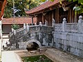
- Ninh Phúc Pagoda is one of the most famous pagodas in Vietnam. Inside, there are various valuable ancient objects and statues, which are considered to be Annamese masterpieces of 17th century wood carving.[2]
- Thuận Thành No 1 High School is one of the top-ranked high schools in Bắc Ninh Province and which was in Vietnam's Top 100 High Schools for many years.
Notable persons
Landscapes
-
-
 Bảo Nghiêm tower in Ninh Phúc Pagoda
 -
 The Rats Taking a Bride (Lão thử thú thân) of Đông Hồ painting


See also
Notes and references
Notes
References
- ^ P. Thủy. "Xem xét, quyết định thành lập một số đơn vị hành chính cấp huyện, cấp xã của 10 tỉnh". Báo điện tử Đại biểu Nhân dân (in Vietnamese).
- ^ "The most famous pagodas in Viet Nam - Ninh Phúc Pagoda - Local Guide". Archived from the original on 2013-06-28. Retrieved 2013-05-17.
Further reading
Bibliography
- Quorum omnium exemplum, in portu regni Tunquini ad Batsham, sub latitudine Boreali 20 gr. 50 min. (Philosophiae Naturalis Principia Mathematica, Liber Tertius. De Mundi Systemate, Propositio XXIV. Theorema XIX, 1687).
- "Ce singulier phénomène a été observé à Batsha, port du royaume de Tunquin, et dans quelques autres lieux. Il est vraisemblable que des observations faites dans les divers ports de la terre, offriroient toutes les variétés intermédiaires entre les marées de Batsha et celles de nos ports." (Exposition du système du monde, Livre quatrième, Chapitre X. "Du flux et du reflux de la mer", 1796).
- George Coedes. The Making of South East Asia, 2nd ed. University of California Press, 1983.
- Trần Ngọc Thêm. Cơ sở văn hóa Việt Nam (The Foundation of Vietnamese Culture), 504 pages. Publishing by Nhà xuất bản Đại học Tổng hợp TPHCM. Saigon, Vietnam, 1995.
- Trần Quốc Vượng, Tô Ngọc Thanh, Nguyễn Chí Bền, Lâm Mỹ Dung, Trần Thúy Anh. Cơ sở văn hóa Việt Nam (The Basis of Vietnamese Culture), 292 pages. Re-publishing by Nhà xuất bản Giáo Dục Việt Nam & Quảng Nam Printing Co-Ltd. Hanoi, Vietnam, 2006.
- Li Tana (2011). "Jiaozhi (Giao Chỉ) in the Han period Tongking Gulf". In Cooke, Nola ; Li Tana ; Anderson, James A. (eds.). The Tongking Gulf Through History. University of Pennsylvania Press. pp. 39–44. ISBN 9780812205022.
- Li Tana, "Towards an environmental history of the eastern Red River Delta, Vietnam, c.900–1400", Journal of Southeast Asian Studies, 2014.
- Samuel Baron, Christoforo Borri, Olga Dror, Keith W. Taylor (2018). Views of Seventeenth-Century Vietnam : Christoforo Borri on Cochinchina and Samuel Baron on Tonkin. Cornell University Press. ISBN 978-1-501-72090-1.
External links
21°03′00″N 106°04′59″E / 21.050°N 106.083°E
Capital: Bắc Ninh | ||
| Bắc Ninh |  | |
| Từ Sơn | ||
| Quế Võ | ||
| Thuận Thành | ||
| Gia Bình District | ||
| Lương Tài District | ||
| Tiên Du District | ||
| Yên Phong District | ||
Districts of the Red River Delta | ||
|---|---|---|
| Hanoi city |
|  |
| Haiphong city | ||
| Bắc Ninh province | ||
| Hà Nam province | ||
| Hải Dương province |
| |
| Hưng Yên province | ||
| Nam Định province | ||
| Ninh Bình province | ||
| Thái Bình province | ||
| Vĩnh Phúc province |
| |
※ denotes provincial seat. | ||
You must be logged in to post a comment.