


Size of this preview: 800 × 578 pixels. Other resolutions: 320 × 231 pixels | 640 × 463 pixels | 1,024 × 740 pixels | 1,280 × 925 pixels | 1,574 × 1,138 pixels.
Original file (1,574 × 1,138 pixels, file size: 1.29 MB, MIME type: image/png)
Summary
| Description |
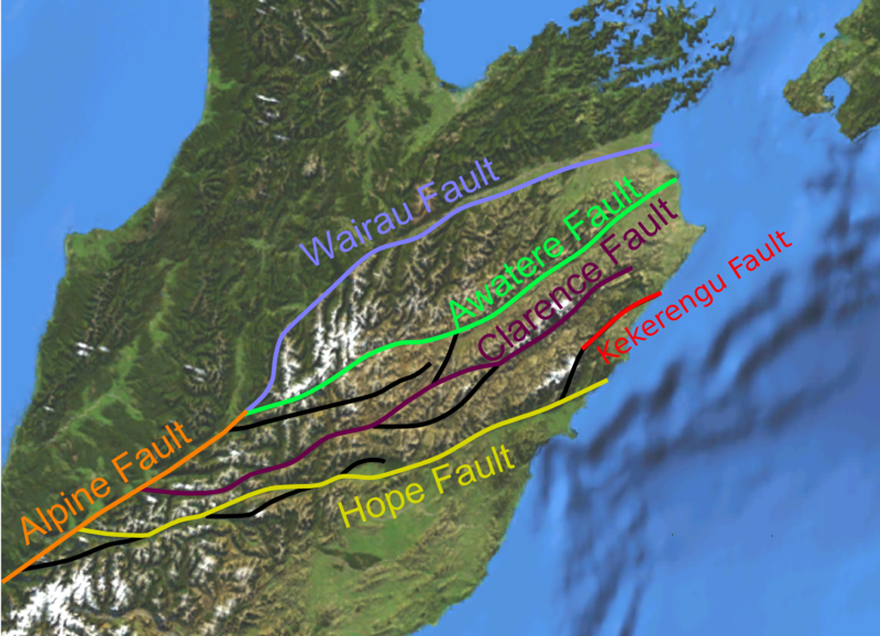
English: Map of the Marlborough Fault System, the set of dextral strike-slip faults that accommodates the switch from the Alpine Fault to the Kermadec Trench along the plate boundary through New Zealand. Base is a screenshot from NASAWorldWind, from the free Blue Marble image courtesy of NASA Earth Observatory. Faults taken from New Zealand Active Faults Database |
| Date | |
| Source | Own work |
| Author | Mikenorton |
Licensing
I, the copyright holder of this work, hereby publish it under the following licenses:
This file is licensed under the Creative Commons Attribution-Share Alike 3.0 Unported license.
- You are free:
- to share – to copy, distribute and transmit the work
- to remix – to adapt the work
- Under the following conditions:
- attribution – You must give appropriate credit, provide a link to the license, and indicate if changes were made. You may do so in any reasonable manner, but not in any way that suggests the licensor endorses you or your use.
- share alike – If you remix, transform, or build upon the material, you must distribute your contributions under the same or compatible license as the original.

|
Permission is granted to copy, distribute and/or modify this document under the terms of the GNU Free Documentation License, Version 1.2 or any later version published by the Free Software Foundation; with no Invariant Sections, no Front-Cover Texts, and no Back-Cover Texts. A copy of the license is included in the section entitled GNU Free Documentation License. |
You may select the license of your choice.
File history
Click on a date/time to view the file as it appeared at that time.
| Date/Time | Thumbnail | Dimensions | User | Comment | |
|---|---|---|---|---|---|
| current | 09:52, 14 November 2016 | | 1,574 × 1,138 (1.29 MB) | Insertcleverphrasehere | Added Kekerengu Fault |
| 21:15, 2 July 2010 |  | 1,574 × 1,138 (1.27 MB) | Mikenorton | Corrected the Clarence Fault - previously the Elliott Fault was coloured as part of the Clarence Fault | |
| 14:26, 27 June 2010 |  | 1,574 × 1,138 (1.27 MB) | Mikenorton | {{Information |Description={{en|1=Map of the Marlborough Fault System, the set of dextral strike-slip faults that accommodates the switch from the Alpine Fault to the Kermadec Trench along the plate boundary through New Zealand. Base is a screenshot from |
File usage
The following 10 pages use this file:
Global file usage
The following other wikis use this file:
- Usage on az.wikipedia.org
- Usage on de.wikipedia.org
- Usage on es.wikipedia.org
- Usage on fr.wikipedia.org
- Usage on hu.wikipedia.org
- Usage on pl.wikipedia.org
- Usage on pt.wikipedia.org
- Usage on ru.wikipedia.org
- Usage on www.wikidata.org
- Usage on zh.wikipedia.org
You must be logged in to post a comment.